
Method for measuring second-grade river-crossing leveling height difference by using intelligent total station

A total station and height difference technology, which is used in measurement devices, height/level measurement, instruments, etc., can solve the problems of cumbersome measurement operations, difficult to guarantee accuracy, and long detours, so as to achieve a simple measurement operation process and improve accuracy. , the effect of offsetting the atmospheric refraction difference

Inactive Publication Date: 2012-01-18
THE FIRST ENG CO LTD OF CTCE GRP
View PDF0 Cites 18 Cited by
  • Summary
  • Abstract
  • Description
  • Claims
  • Application Information

AI Technical Summary

Problems solved by technology

At present, my country generally uses three methods for cross-river leveling surveys: one is the detour of the level instrument, but the detour is too far, the error is accumulated, the accuracy is difficult to guarantee and the workload is heavy; the other is the traditional cross-river leveling survey, such as optical surveying. The micro-device method, the inclined spiral method, the theodolite inclination method, etc., need to make a special target plate for observation, the measurement operation is cumbersome, and the requirements are strict, the human error is large, and there are high requirements for the observer and the ruler; Distance triangle elevation method, this method is affected by the weather and environment, especially the atmospheric refractive difference in the river environment, and human error is also introduced in the process of optical centering and measuring the height of the instrument and the height of the reflective prism

Method used


Image

  • Method for measuring second-grade river-crossing leveling height difference by using intelligent total station
  • Method for measuring second-grade river-crossing leveling height difference by using intelligent total station
  • Method for measuring second-grade river-crossing leveling height difference by using intelligent total station

Examples


Embodiment Construction

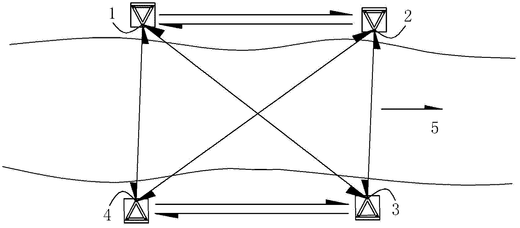
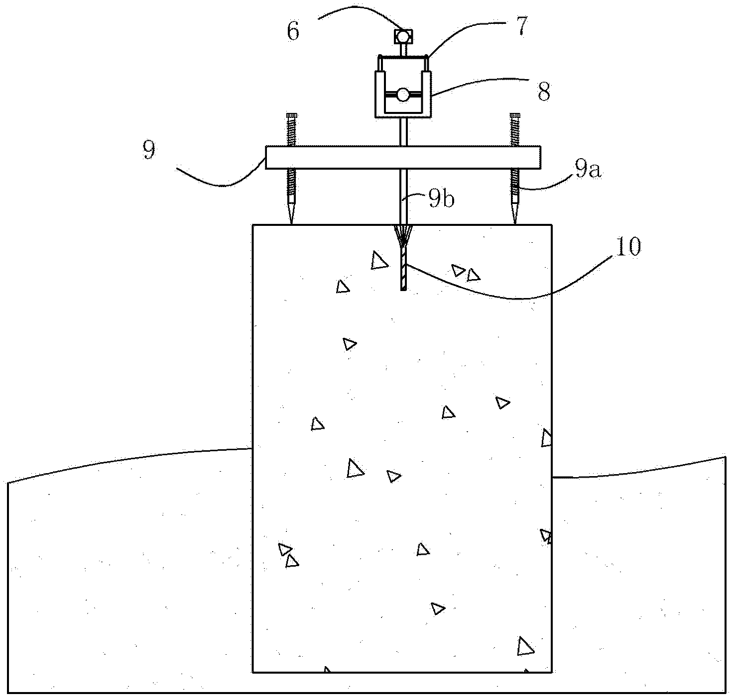
[0026] see figure 1 , figure 2 and image 3 , the method for utilizing the intelligent total station in the present embodiment to measure the second-class cross-river level difference is to proceed as follows:

[0027] a. Set the cross-river benchmarks

[0028] On the river 5, each benchmarking point is set with the two banks of the crossed river section as the cross-river benchmarking point area, and each benchmarking point includes: the first benchmarking point 1 and the second benchmarking point located on one bank of the river and 1-5m away from the bank 2. The distance between the first benchmarking point 1 and the second benchmarking point 2 is 80-120m; and the third benchmarking point 3 and Fourth Benchmark 4.

[0029] The setting of each benchmarking point: Observation pier 11 is respectively arranged at the position of each benchmarking point, and a benchmarking point base 10 with cone socket is buried on the top surface of observation pier 11, and the centering ...


PUM


Abstract

The present invention discloses a method for measuring second-grade river-crossing leveling height difference by using an intelligent total station. The method is characterized in that, various river-crossing leveling points are firstly arranged; the height difference among the river-crossing leveling points is measured; an intelligent total station and a reflecting prism are adopted among the river-crossing leveling points positioned on different banks during the measurement process to carry out the synchronous and opposite observation of both banks of the river. According to the present invention, the equipment height is fixed, the alignment is forced to be performed, the intelligent total station and the reflecting prism are arranged integratedly; because the optical alignment and the measurement of the equipment height are not required, the error of the optical alignment and the error of the measurement of the equipment height are avoided; the synchronously-performed river-crossing leveling height measurement counteracts the atmospheric refraction error so as to substantially improve work efficiency and measurement accuracy.

Description

technical field [0001] The invention relates to a leveling survey method, which is mainly used for second-class level cross-river surveying. Background technique [0002] At present, bridges crossing rivers, rivers and even seas in various projects in my country have generally appeared, and the difficulty of cross-river leveling has followed. The accuracy of leveling is crucial to the quality of on-site elevation construction. At present, my country generally uses three methods for cross-river leveling surveys: one is the detour of the level instrument, but the detour is too far, the error is accumulated, the accuracy is difficult to guarantee and the workload is heavy; the other is the traditional cross-river leveling survey, such as optical surveying. The micro-device method, the inclined spiral method, the theodolite inclination method, etc., need to make a special target plate for observation, the measurement operation is cumbersome, and the requirements are strict, the h...

Claims


Application Information

Patent Timeline
IPC IPC(8): G01C13/00G01C5/02
Inventor 梁超张杰胜张宏斌阮仁义董上锋刘晓东刘帅帅徐海林李文成李小政周健宝
Owner THE FIRST ENG CO LTD OF CTCE GRP
Learn More