Utility tunnel layout method based on three-dimensional virtual city

A technology of three-dimensional virtual and common ditch, applied in image data processing, special data processing applications, instruments, etc., can solve problems such as inability to intuitively display the mutual positions of pipeline distribution pipe sections, difficult dynamic management of common ditch, pipeline accidents, etc.

Inactive Publication Date: 2012-05-23
上海日浦信息技术有限公司
View PDF0 Cites 7 Cited by
  • Summary
  • Abstract
  • Description
  • Claims
  • Application Information

AI Technical Summary

Problems solved by technology

[0004] The traditional underground professional pipeline network adopts manual methods, the management efficiency is low, it is difficult to dynamically manage the common trench, and it is easy to cause pipeline ac

Method used


Image

  • Utility tunnel layout method based on three-dimensional virtual city
  • Utility tunnel layout method based on three-dimensional virtual city

Examples


Embodiment Construction

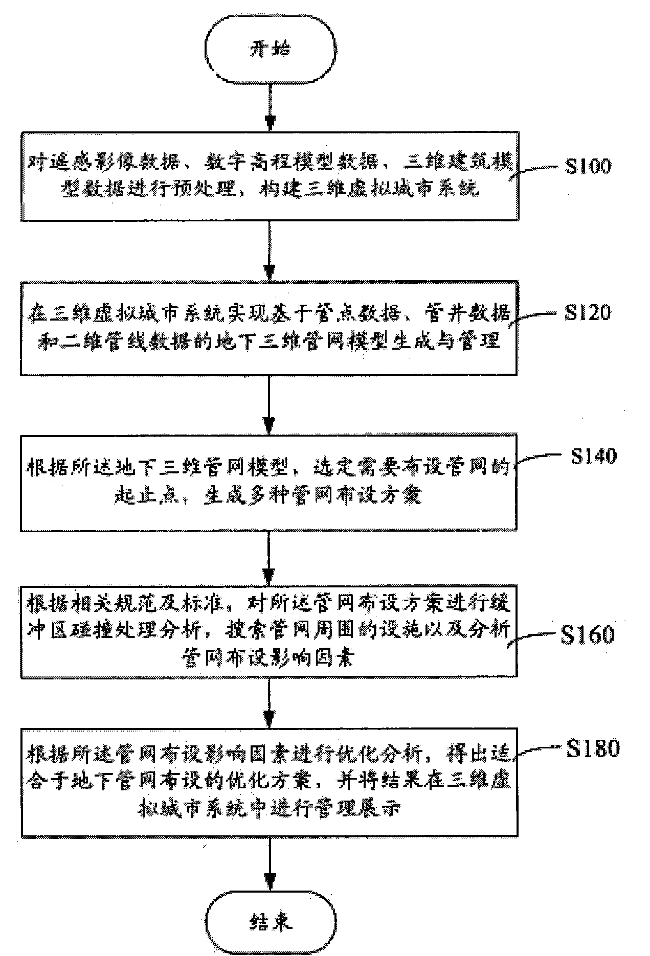
[0016] figure 1 A flow chart of a common ditch laying method based on a three-dimensional virtual city is shown. The specific process is as follows:

[0017] Step S100, preprocessing remote sensing image data, digital elevation model data (Digital ElevationModel, "DEM"), and 3D building model data to construct a 3D virtual city system.

[0018] First, remote sensing image data, digital elevation model data, and 3D building model data should be preprocessed. The processing process includes data fusion processing of remote sensing image data and DEM data, and importing the fused data into the 3D virtual city system; then outputting 3D architectural model data in batches in the form of model files, and performing corresponding model conversion through software , so far the preprocessing is completed. Then import the 3D architectural models into the 3D virtual city system in batches, and modify the corresponding parameters to make the 3D architectural models and remote sensing ...


PUM


Abstract

The invention relates to a utility tunnel layout method based on a three-dimensional virtual city, which comprises the steps of preprocessing remote sensing image data, digital elevation model data and three-dimensional building model data and establishing a three-dimensional virtual city system; in the three-dimensional virtual city system, realizing the generation and management of an underground three-dimensional pipe network model based on pipe point data, pipe well data and two-dimensional pipeline data; according to the underground three-dimensional pipe network model, selecting the starting point and the end point of a needed pipe network and generating various pipe network layout scheme; according to relevant specifications and standards, conducting collision processing to the pipe network layout scheme, searching for pipe network surrounding facilities and analyzing pipe network layout influence factors; and conducting optimization analysis according to the pipe network layout influence factors, obtaining an optimized scheme suitable for the underground pipe network layout and administratively demonstrating a result in the three-dimensional virtual city system. By building the three-dimensional virtual city, building a dynamic model and generating and optimizing various pipe network layout schemes, the goal that the pipe network layout has a basis is realized and a support is provided for planning the underground sources and pipelines of cities.

Description

technical field [0001] The invention relates to a common ditch layout method, in particular to a common ditch layout method based on a three-dimensional virtual city. Background technique [0002] Urban common ditch is responsible for the tasks of information transmission, energy transmission, water supply and drainage, etc., and is the foundation of urban development, so it is known as the lifeline of the city. However, with the rapid development of the city, the material flow and energy flow in the city are gradually increasing, which makes the spatial distribution of urban underground pipelines more and more narrow. To explore the optimization method of underground three-dimensional pipeline network layout will provide a basis for urban underground resource management, pipeline planning and urban planning. Construction provides auxiliary decision-making, which is of great significance. [0003] Therefore, how to achieve better management of the layout of underground spac...

Claims


Application Information

Patent Timeline
IPC IPC(8): G06F17/50G06T17/05
Inventor 严峰
Owner 上海日浦信息技术有限公司
Why Eureka
Try Eureka