Airborne navigation nacelle

A technology for pods and unmanned aerial vehicles, which is used in integrated navigators, aircraft parts, transportation and packaging, etc., can solve problems such as reliability constraints, and achieve the effects of improving reliability, increasing integration, and simplifying working modes.

Active Publication Date: 2013-10-16
HEBEI HANGUANG HEAVY IND
View PDF4 Cites 0 Cited by
  • Summary
  • Abstract
  • Description
  • Claims
  • Application Information

AI Technical Summary

Problems solved by technology

From the perspective of positioning accuracy, although the accuracy of the extended platform navigation coordinate positioning method is higher than other types, the GPS navigation information that needs to be used is provided by the United States, so its reliability is restricted in extraordinary times

Method used


Image

  • Airborne navigation nacelle
  • Airborne navigation nacelle
  • Airborne navigation nacelle

Examples


Embodiment Construction

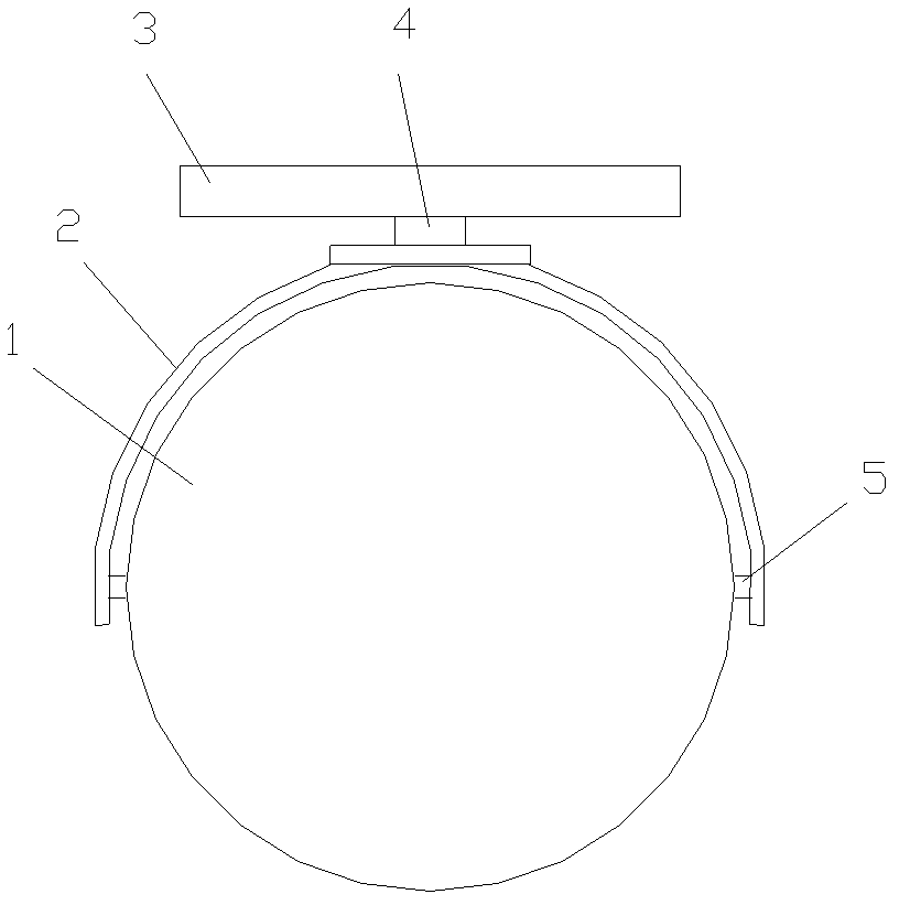
[0013] Such as figure 1 As shown, the present invention includes an inner ring platform 1, an outer ring frame 2 and a base 3, the inner ring platform 1 is hinged with the outer ring frame 2 through a rotating shaft 5, the outer ring frame 2 is hinged with the base 3 through a hinge shaft 4, and the base 3. Fixed on the bottom of the aircraft, the inner ring platform 1 has a visible light television imaging system and a laser rangefinder; the inner ring platform 1 is a stable benchmark for inertial devices, including a two-degree-of-freedom gyroscope, an accelerometer, an imaging device, a laser Range finder and dual channel resolver angle sensor. The outer ring frame rotates 360 degrees in azimuth and includes a dual-channel resolver angle sensor. The base is configured with a micromechanical gyroscope along the longitudinal axis of the UAV to measure the three-axis attitude of the carrier and compensate for navigation-related errors. An airspeed meter is arranged along the...


PUM


Abstract

The invention relates to an airborne navigation nacelle which is used for providing enemy destination parameters to a main control room and comprises an inner ring platform, an outer ring frame and a base, wherein, the inner ring platform is hinged with the outer ring frame through a rotating shaft; the outer ring frame is hinged with the base through a hinge shaft; the base is fixed at the bottom of an airplane; a visible light television imaging system and a laser rangefinder are arranged inside the inner ring platform; the inner ring platform comprises a two-degree-of-freedom gyroscope, accelerometers, an imaging device, the laser rangefinder and a double-channel rotary transforming angle transducer; in addition, the outer ring frame comprises the double-channel rotary transforming angle transducer; a micromachining gyroscope is arranged on the base in the ordinate axis direction of an unmanned plane, measures the three-axis attitude of a carrier, and offsets the correlative navigation errors. Air speedometers are arranged in the ordinate axis direction and the pitch axis direction of the unmanned plane; an altimeter is arranged at the bottom of the base so as to measure the height of the unmanned plane; and the accelerometers are arranged at the two ends of the base so as to achieve levelling when in initial alignment. The airborne navigation nacelle can integrally detect, search and track a target, and has the advantages of high system reliability and low cost.

Description

technical field [0001] The invention relates to an airborne navigation pod, which is used for providing parameters of enemy targets to a main control room. Background technique [0002] In modern high-tech warfare, with the development of missile technology, the combat radius of ship missiles has increased, and the sea battlefield has become wider. Over-the-horizon attack operations have become the main combat style of surface ship anti-ship warfare. The so-called over-the-horizon attack refers to a missile attack on a target beyond the over-the-horizon of the shipboard radar by using a special long-range target indication system to provide target indication. The premise of realizing the over-the-horizon missile attack on the sea is that the anti-ship missile weapon platform must first locate the target over-the-horizon. The methods to realize over-the-horizon positioning mainly include relay station positioning, extended platform navigation coordinate positioning method an...

Claims


Application Information

Patent Timeline
Patent Type & Authority Patents(China)
IPC IPC(8): B64D47/00B64D47/08G01C21/24
Inventor 乔海岩可伟戴春江
Owner HEBEI HANGUANG HEAVY IND
Why Eureka
Try Eureka