
Elevation control method and system based on global position system (GPS) and laser technology

A technology of elevation control and laser system, applied in the direction of earth mover/shovel, construction, etc., to achieve the effect of ensuring work reliability, improving work quality, and fast dynamic control

Active Publication Date: 2014-11-12
CHINESE ACAD OF AGRI MECHANIZATION SCI +1
View PDF7 Cites 0 Cited by
  • Summary
  • Abstract
  • Description
  • Claims
  • Application Information

AI Technical Summary

Problems solved by technology

The horizontal measurement accuracy of the low-precision GPS receiving module can meet the requirements, but the error is large when measuring the elevation coordinates; the cost of the high-precision GPS receiving module is very high, so most of them choose reasonable price, high precision, support RTK (Real Time Kinematic, real-time dynamic measurement) technology dual-frequency GPS-OEM board (RTK GPS-OEM board) to complete the collection of measuring point information

Method used


Image

  • Elevation control method and system based on global position system (GPS) and laser technology
  • Elevation control method and system based on global position system (GPS) and laser technology
  • Elevation control method and system based on global position system (GPS) and laser technology

Examples


Embodiment Construction

[0051] Specific embodiments of the present invention are given below, and the present invention is further described in conjunction with the accompanying drawings.

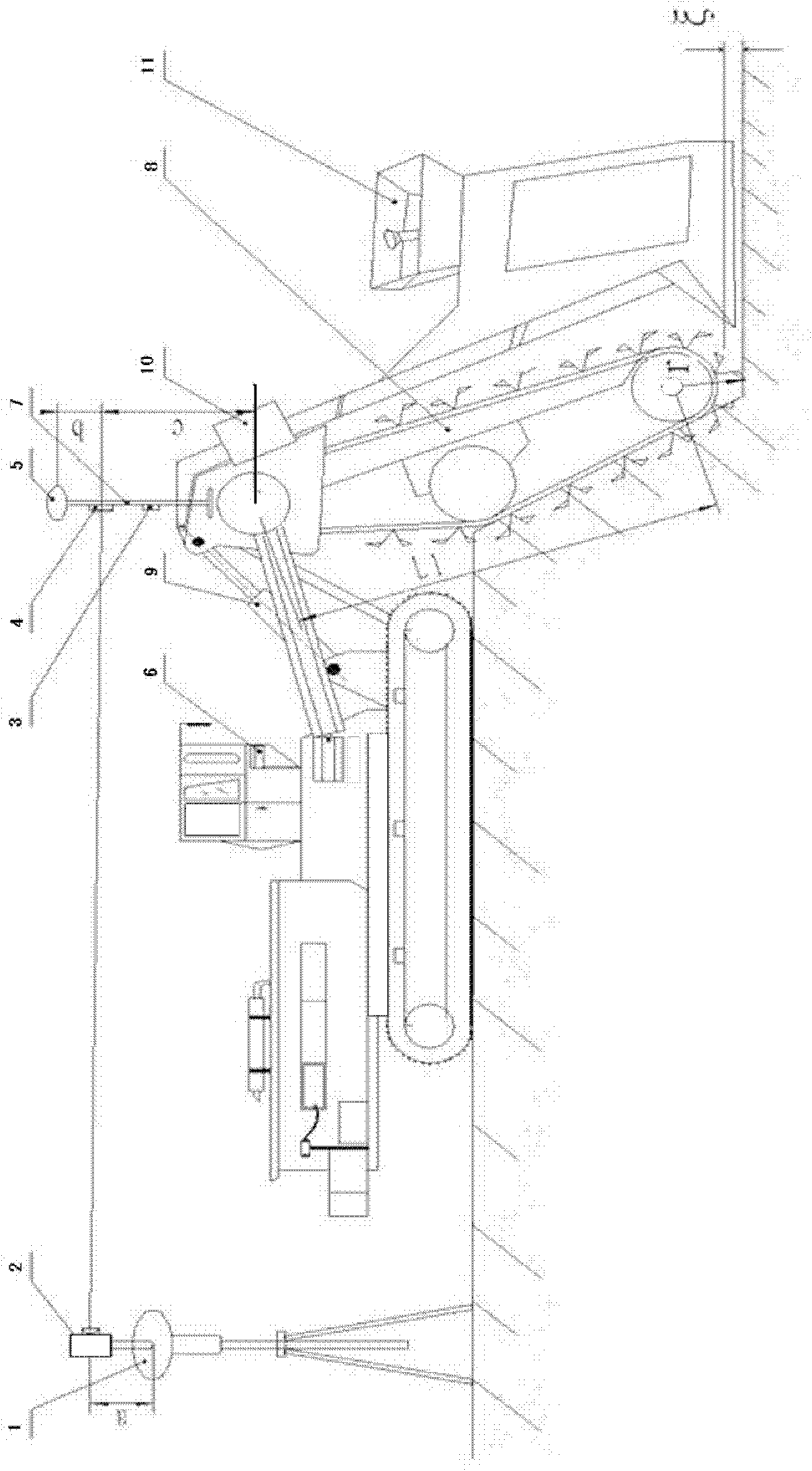
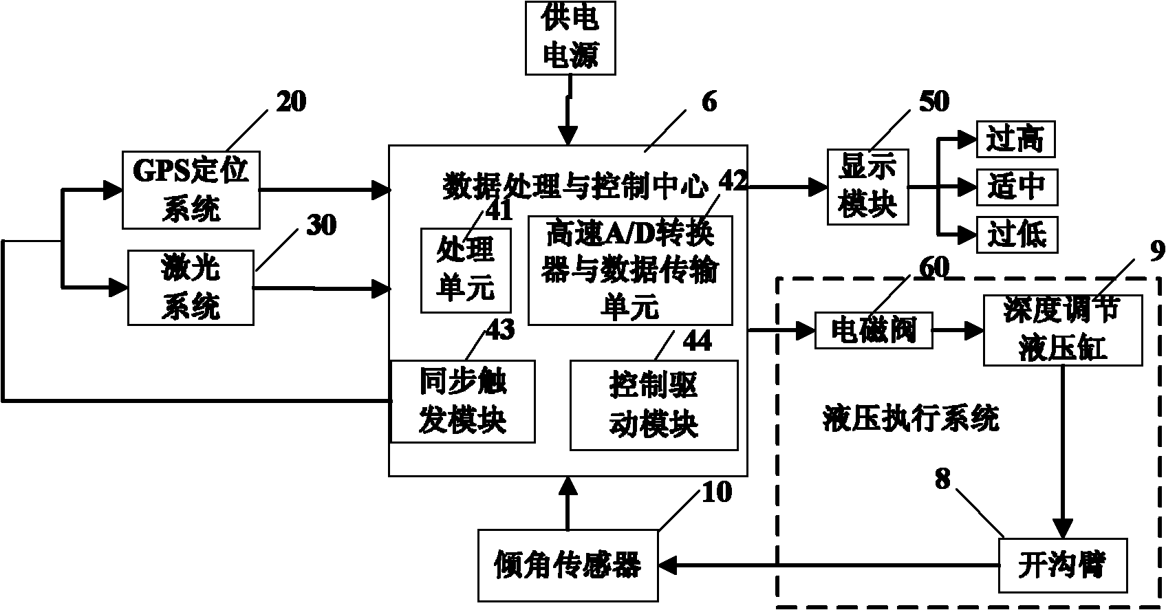
[0052] as attached figure 1 As shown, in one embodiment of the present invention, the elevation control system based on GPS and laser technology mainly includes GPS base station 1, laser transmitter 2, GPS receiving module 3, laser receiver 4, GPS antenna 5, data processing and control Center 6, measuring rod 7, ditching arm 8, depth adjustment hydraulic cylinder 9, inclination sensor 10, pipe box 11, etc. Wherein, the GPS receiving module 3 , the laser receiver 4 , and the inclination sensor 10 are respectively connected with the data processing and control center 6 . The GPS antenna 5 is installed on the top of the measuring pole 7, the laser receiver 4 is fixed on the measuring pole 7 top (keeps a set distance with the GPS antenna 5), ​​and the laser transmitter 2 is fixed on a tripod.

[0053] The GPS recei...


PUM


Abstract

The invention discloses an elevation control method based on a global position system (GPS) and a laser technology, which is used for ditching and pipe-laying machine performing ditching and pipe-laying operations and is characterized by comprising the following steps: step 100, arranging a GPS base station and determining position coordinates of a laser emitter and three-dimensional coordinates of a laser receiver fixed on a ditching arm; step 200, judging whether a GPS signal and a laser signal are valid or not and performing corresponding data storage and positioning information processing; step 300, calculating three-dimensional coordinates of the bottom end of the ditching arm in a space coordinate system and driving the ditching arm to move; and step 400, comparing a current ditching arm elevation signal with a preset ditching arm elevation signal to confirm elevation control information and achieving control of deep adjustment of a hydraulic cylinder.

Description

technical field [0001] The present invention is aimed at the technical field of automatic control of agricultural machinery and equipment, and relates to a method and system for elevation control, in particular to a method and system for field operations of ditching and pipe-laying machines using GPS (Global Position System, Global Positioning System) technology combined with laser technology. A method and system for real-time control of ditch depth and slope. Background technique [0002] Before the 1990s, the elevation (ditching depth and slope) of the trenching pipelayer has been measured manually and controlled by mechanical devices, which is not only labor-intensive, but also low in efficiency, and it is difficult to avoid some human errors. affect the construction quality. Since the 1990s, with the development and progress of agricultural machinery automation, the elevation control of trenching and pipelayers is generally completed by laser guidance devices. The bas...

Claims


Application Information

Patent Timeline
Patent Type & Authority Patents(China)
IPC IPC(8): E02F5/10
Inventor 赵化平张小超段京云胡小安伟利国王丽丽
Owner CHINESE ACAD OF AGRI MECHANIZATION SCI
Learn More