Building area extraction method based on LiDAR data

A technology for area extraction and buildings, applied to radio wave measurement systems, instruments, etc., to achieve reliable data support, good extraction results, and avoid information loss

Inactive Publication Date: 2012-06-27
NANJING UNIV
View PDF3 Cites 45 Cited by
  • Summary
  • Abstract
  • Description
  • Claims
  • Application Information

AI Technical Summary

Problems solved by technology

[0013] In view of the existing segmentation methods, the present invention mostly converts LiDAR data into depth images, thereby using the original image segmentation algorithm for processing instead of directly processing 3D point cloud data, and the original mathematical morphology method Deficiency, the present invention provides a kind of building region ext

Method used


Image

  • Building area extraction method based on LiDAR data
  • Building area extraction method based on LiDAR data
  • Building area extraction method based on LiDAR data

Examples


Embodiment 1

[0050] The method proposed by the present invention adopts Visual Studio 2008 development platform C# language programming to realize, and the LiDAR data to be processed is point-shaped data, selects and adopts open-source geographic data format conversion class library OGR to finish reading and writing and other processing to point cloud data here operate.

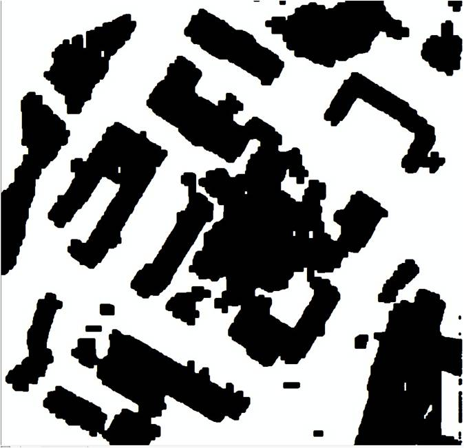
[0051] Refer to the four technical steps of the technical plan and figure 1 The reverse iterative mathematical morphology filtering method is shown in the technical flow chart to complete the extraction of building points. The specific processing steps are as follows:

[0052] Step 1: Pre-processing of LiDAR data

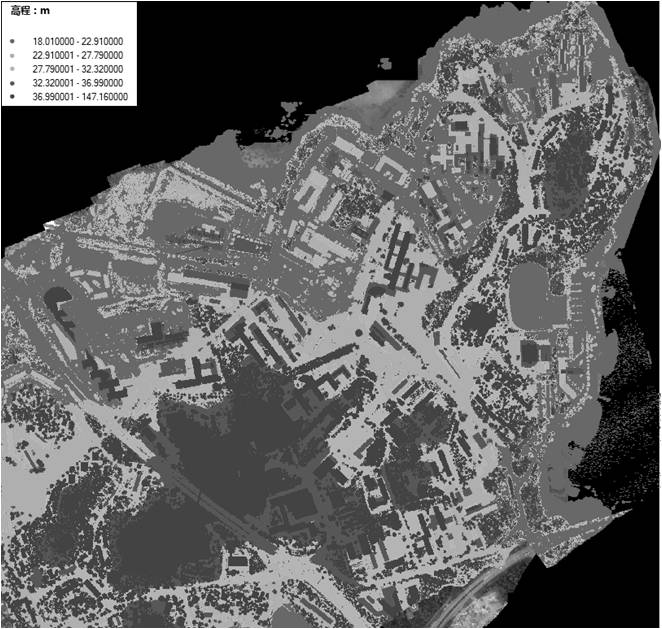
[0053] The present invention uses large-scale LiDAR data to carry out reverse iterative segmentation experiments. The experimental area is about 2000m×2000m, and the original LiDAR data is as follows: figure 2 As shown (colored by elevation), the average point spacing is about 1m, the elevation accuracy is a...


PUM


Abstract

The invention discloses a building area extraction method based on LiDAR data, which belongs to the field of extraction of building through the LiDAR data and includes early-age processing of the LiDAR data, resampling of original LiDAR data, reverse iteration mathematical morphological filtering and separation of building and dense trees. The building area extraction method directly processes three-dimensional (3D) point cloud data instead of converting the point cloud into depth images, avoids information loss and added calculation quantity in the conversion process, simultaneously utilizesdifferent windows to conduct mathematical morphological filtering operation through reverse gradual iteration, basically removes effects of terrain fluctuation on the building in the mathematical morphological filtering and obtains high extraction accuracy. The building area extraction method can quickly and accurately extract LiDAR points belonging to the building area from a large range of LiDAR points and is capable of providing reliable data support for urban three-dimensional modeling.

Description

technical field [0001] The present invention relates to a method of extracting buildings from LiDAR data. In particular, a method for extracting building points from LiDAR point data using a reverse iterative mathematical morphology method. Background technique [0002] Airborne Lidar (Airborne Light Detection And Ranging, abbreviated as LiDAR; also known as Airborne Laser Scanner, abbreviated as: ALS) is a new type of measurement technology that has developed rapidly in the past decade and is widely used It has shown great prospects in the application of ground data detection and model restoration and reconstruction, and has gradually become an important method for obtaining 3D urban data models. [0003] As the quality of LiDAR data continues to improve, become easier to obtain, and continue to drop in price, the demand for automatic detection and reconstruction of 3D ground objects from LiDAR data will also increase. The most popular model. Real-time and accurate updat...

Claims


Application Information

Patent Timeline
IPC IPC(8): G01S7/48
Inventor 程亮李满春刘永学陈焱明赵威张雯童礼华李真蔡文婷杨康冯逍
Owner NANJING UNIV
Why Eureka
Try Eureka