Browser-based marine navigation system

A technology for ship navigation and browser, applied in navigation, surveying and mapping, navigation, instruments and other directions, can solve the problems of difficult to connect the external navigation equipment of the ship, users cannot further browse the chart, and affect the safe navigation of the ship, so as to improve transportation and safety. The effect of logistics efficiency, promotion of supervision capacity, and safety of navigation

Inactive Publication Date: 2012-08-15
DALIAN MARITIME UNIVERSITY
View PDF4 Cites 15 Cited by
  • Summary
  • Abstract
  • Description
  • Claims
  • Application Information

AI Technical Summary

Problems solved by technology

[0009] However, the above-mentioned Web-based electronic chart application mode has several shortcomings that are difficult to solve for ship navigation applications
[0010] 1) Due to the security restrictions of the web browser, this mode is difficult to connect to the external navigation equipment of the ship, and obtain the real-time dynamics of the ship's navigation status and the surrounding navigation traffic environment
[0011] 2) The front end of the user obtains the nautical chart in the form of a picture, that is, a raster chart rather than a vector chart, which does not contain the spatial and attribute information of each element in the specific nautical chart, so these picture data cannot be used for the navigation process Spatial analysis and calculation such as mark collision alarm and yaw alarm required in the system, providing alarm and navigation services for ships
[0012] 3) When the user roams and zooms in on the chart, he must continuously make requests to the server, and then the server sends the generated pictures to the front-end display. The network data transmission volume is relatively large, and the display must also be delayed.
Moreover, once the ship is temporarily disconnected (this is a high probability event for the current inland mobile communication network conditions), the user will not be able to browse the chart further, which will inevitably affect the safe navigation of the ship
[0013] Because of the above-mentioned limitations, the web-based nautical chart application mode has not been successfully applied in ship navigation, but is mostly used in the dynamic monitoring of ships by shipping companies or regulatory authorities.

Method used


Image

  • Browser-based marine navigation system
  • Browser-based marine navigation system
  • Browser-based marine navigation system

Examples


Embodiment Construction

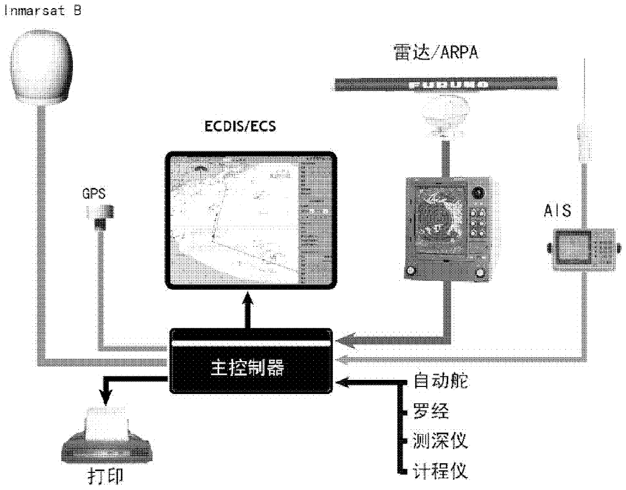
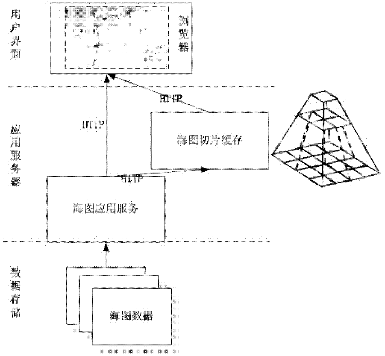
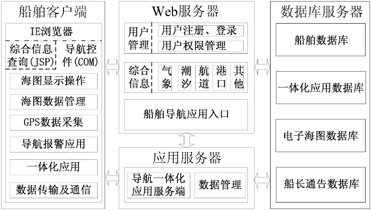
[0039] The present invention will be further described below in conjunction with the accompanying drawings. image 3 Shown is a schematic diagram of the system software structure and information flow of the present invention, Figure 4 It is an organizational structure diagram of the navigation control of the present invention, and its surroundings are interfaces and connection points of the navigation control. Figure 5 It shows a screenshot of the navigation page, the chart area in the middle of the interface is drawn and controlled by the navigation control, while the top toolbar, the bottom status bar, the left chart information bar and the right navigation information bar are all implemented by JSP interface. The navigation control and JSP communicate and interact through the interface of the control and the connection point. Image 6 It shows an example of the application of navigation control and JSP interaction in the nautical chart information query function.

[00...


PUM


Abstract

The invention discloses a browser-based marine navigation system. The system is composed of three layers of network structures including a marine client, a Web server, an application server and a database server. The Web server is respectively in bidirectional connection with the marine client, the application server and the database server, and the application server is respectively in bidirectional connection with the marine client and the database server. The system adopts a mode of operating based on an IE (Internet Explorer), can avoid trouble and high cost in installation and maintenance of ECDIS (Electronic Chart Display And Information System) / ECS (Electronic Chart System) on a large number of ships in inland rivers, and the comprehensive navigation server can be obtained just with low mobile network communication cost, thus, the navigation safety of the ships is improved greatly. According to the invention, the three layers of network structures for integrated navigation service are provided, intercommunication between the browser-based marine navigation system and a shore-based system is established, and the function that the ship can obtain all-around integrated information service from one terminal is realized.

Description

technical field [0001] The invention relates to a ship navigation technology, in particular to a browser-based ship navigation system. Background technique [0002] The navigation safety of ships has always been the most concerned topic in the shipping industry. With the rapid development of cutting-edge technologies in multiple disciplines such as computers, communications, networks, and information fusion, the birth, promotion and application of electronic chart-based ship navigation systems provide a strong guarantee for safe navigation of ships. In recent years, the International Maritime Organization has further proposed the concept of E-Navigation, which aims to coordinate the collection, integration, exchange, display and analysis of maritime information on ships and shores by electronic means, so as to enhance the navigation of ships from dock to dock and Related services to achieve the goals of maritime safety, security and protection of the marine environment. Co...

Claims


Application Information

Patent Timeline
Patent Type & Authority Applications(China)
IPC IPC(8): G01C21/00G06F9/44
Inventor 潘明阳胡景峰李超郝江凌王德强赵丽宁李邵喜赵德鹏李源惠童晨涛
Owner DALIAN MARITIME UNIVERSITY
Why Eureka
Try Eureka