Synthetic aperture radar (SAR) tomography three-dimensional imaging method

A three-dimensional imaging and high-level technology, applied in the direction of radio wave reflection/re-radiation, using re-radiation, measuring devices, etc., can solve problems such as poor computing efficiency and unguaranteed robustness, and achieve good reconstruction accuracy and high reconstruction Robustness, the effect of ensuring optimality

Inactive Publication Date: 2012-09-12
UNIV OF ELECTRONICS SCI & TECH OF CHINA
View PDF1 Cites 36 Cited by
  • Summary
  • Abstract
  • Description
  • Claims
  • Application Information

AI Technical Summary

Problems solved by technology

The BP algorithm has good stability, but its operation efficiency is poor; on the other hand, although the greedy algorithm has high operation efficiency, its robustness cannot be guaranteed.

Method used


Image

  • Synthetic aperture radar (SAR) tomography three-dimensional imaging method
  • Synthetic aperture radar (SAR) tomography three-dimensional imaging method
  • Synthetic aperture radar (SAR) tomography three-dimensional imaging method

Examples


Embodiment Construction

[0023] The present invention will be further described below in conjunction with the accompanying drawings and specific embodiments.

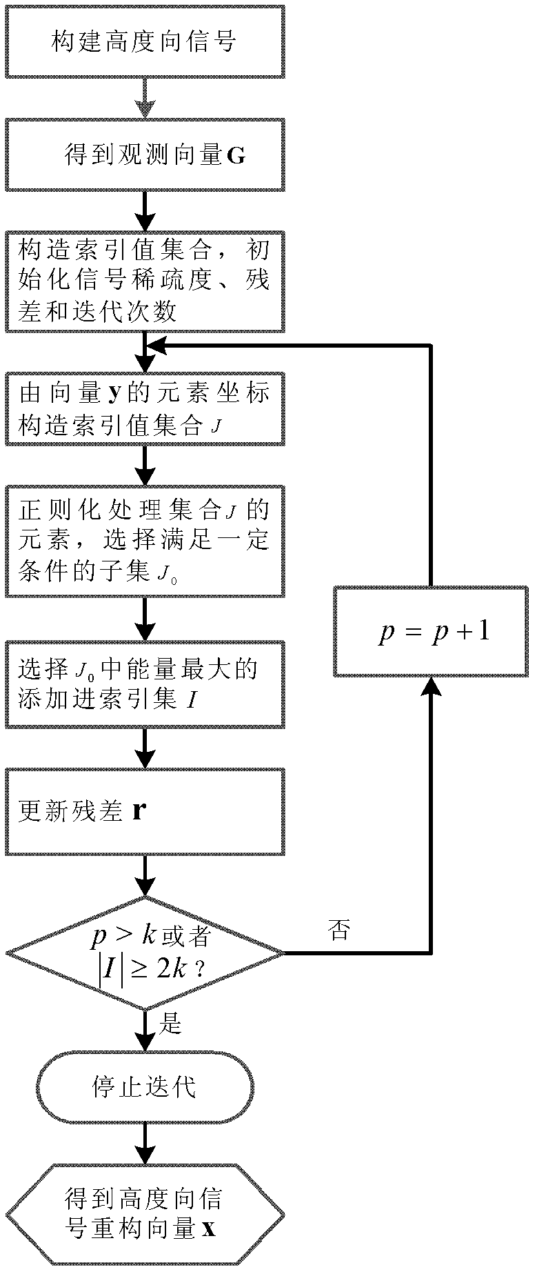
[0024] The SAR tomographic three-dimensional imaging method of the present invention, such as figure 1 As shown, it specifically includes the following steps:

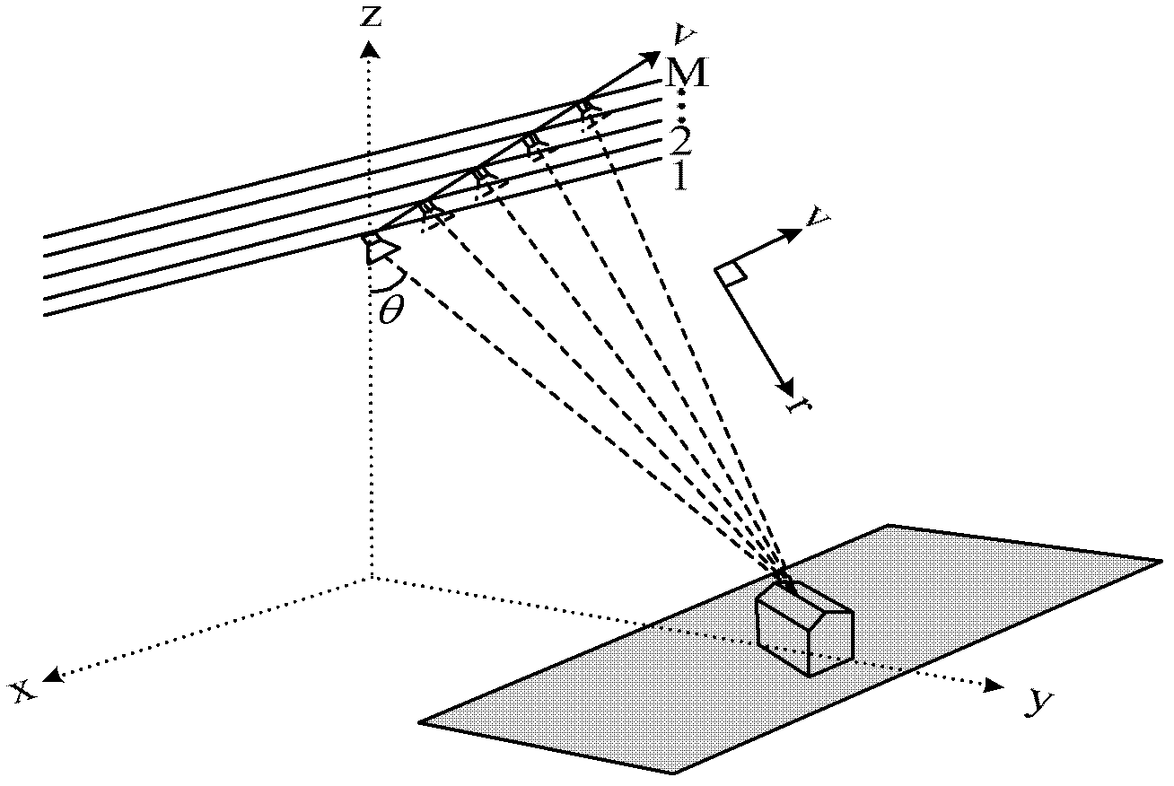
[0025] Step 1. The SAR platform collects echo data m times from the same measured area at different times and different track positions. Then use the existing classical two-dimensional SAR imaging method that preserves the phase information to obtain the two-dimensional complex image of each flight. Azimuth-distance pixel points in the two-dimensional complex image (x 0 , r 0 ) The gray value obtained in the mth flight of ) is as follows:

[0026] g ( x 0 , r 0 , s m ) = ...


PUM


Abstract

The invention discloses a synthetic aperture radar (SAR) tomography three-dimensional imaging method. According to the method, regularized orthogonal matching pursuit (ROMP) is combined with an SAR tomography three-dimensional imaging system, and height direction sparse signals are accurately reconstructed to realize height dimension focusing. When a measurement matrix strictly meets a restricted isometry property, any sparse signals can be accurately reconstructed by the method. By the imaging method, a sparse signal with the sparsity of k is subjected to iteration for k times to obtain a support set I of which the atomic number, namely absolute I is more than or equal to 2k, so that a height direction sparse signal is accurately reconstructed, the operation amount is small, and the operation efficiency is high; and moreover, observation vectors are sorted during iteration each time, the optimality of iteration is ensured and the reconstructing robustness is high.

Description

technical field [0001] The invention belongs to the technical field of electronic signal processing, relates to the technical fields of space remote sensing and space-to-earth observation information processing, and in particular to an airborne synthetic aperture radar (Synthetic Aperture Radar, SAR) tomographic three-dimensional imaging technology. Background technique [0002] SAR is an important milestone in the development of radar technology in the 20th century. It uses the correlation of radar echo signals to accumulate the Doppler frequency shift of echo signals during radar movement, and synthesizes an equivalent radar aperture in the direction of radar movement. Realize high-resolution imaging in azimuth. Because SAR adopts the active working mode, it performs imaging processing on the reflected echoes of electromagnetic waves emitted by itself, and is not limited by the external environment such as light and temperature. field has been widely used. [0003] Tradi...

Claims


Application Information

Patent Timeline
Patent Type & Authority Applications(China)
IPC IPC(8): G01S13/90
Inventor 闵锐曹宗杰黄伟窦宏林皮亦鸣范录宏
Owner UNIV OF ELECTRONICS SCI & TECH OF CHINA
Why Eureka
Try Eureka