On-line linkage update service method of multi-scale geographic data

A geographical data and multi-scale technology, applied in the field of network geographic information system and service, can solve the problems of unchanging data waste, difficulty of incremental dynamic update, data source and result data cannot be shared and disseminated in time, to overcome data wasteful effect

Inactive Publication Date: 2012-09-26
WUHAN UNIV
View PDF1 Cites 17 Cited by
  • Summary
  • Abstract
  • Description
  • Claims
  • Application Information

AI Technical Summary

Problems solved by technology

These existing methods mainly have problems such as inconsistency of geospatial database data status, isolated update of single fixed-scale data, difficulty in incremental dynamic update, and these data update methods will also cause data source and result data to not be shared and disseminated in time, affecting man

Method used


Image

  • On-line linkage update service method of multi-scale geographic data
  • On-line linkage update service method of multi-scale geographic data
  • On-line linkage update service method of multi-scale geographic data

Examples


Embodiment Construction

[0025] The present invention will be described in further detail below in conjunction with the accompanying drawings and embodiments.

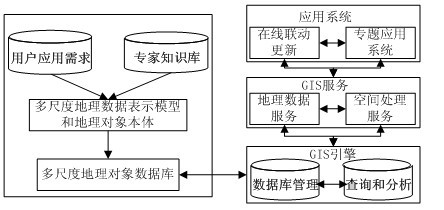
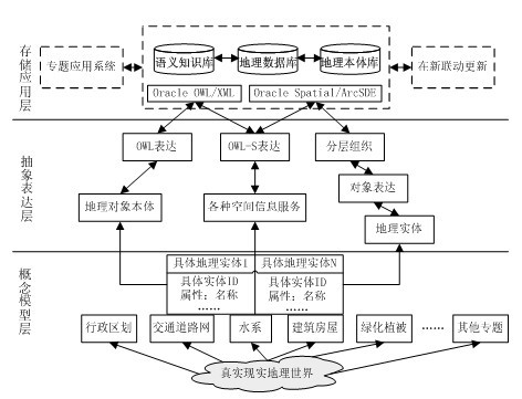
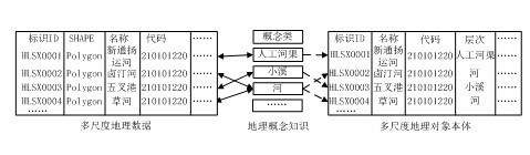
[0026] The embodiment of the present invention establishes a multi-scale geographic data expression model that integrates ontology semantic information, establishes a multi-scale geographic object database based on the model, and centrally organizes and manages the largest scale and multiple key scale data, as a digital city geographic space framework construction The basic geographic information database, combined with the expert knowledge base and user application requirements to establish a multi-scale geographic object database based on geographic ontology, see figure 1 . Based on this multi-scale geographic object database, traditional GIS engines are used to provide spatial database management, query and analysis functions, and GIS services such as geographic data services and spatial processing services for source data conversion are ob...


PUM


Abstract

The invention provides an on-line linkage update service method of multi-scale geographic data in an internet mode. A multi-scale geographic data linkage back-trace expansion updating mechanism is achieved, and geographic ontology is applied to establish a multi-scale geographic data presentation model and construct a multi-scale geographic special database. A characteristic variable quantity of different-phase multi-source data is discovered by applying change detection algorithm, an incremental change data package and ground state geographic data are subjected to element-level on-line update to form uptodate state geographic data, and the incremental change data package is expanded and updated to other-scale geographic data by multi-scale data integration and service composition of spatial information services. By the on-line linkage update service method of the multi-scale geographic data, integration and sharing of the multi-source heterogeneous multi-scale geographic database are guaranteed while on-line update, linkage update and dynamic update of service-oriented distributed geographic information processing are achieved.

Description

technical field [0001] The invention belongs to the technical field of network geographic information systems and services, and in particular relates to a new online linkage update service method supporting multi-scale geographic object databases. Background technique [0002] Online linkage update service is a key technology in the integration, sharing and update application of multi-scale geographic data. It conforms to the development trend of network GIS (Geographical Information System, geographic information system) and spatial information services. The integration framework and shared application mode of geographic data directly affect the operation and maintenance of multi-scale geographic data and its spatial information system. In the distributed network environment, combined with the open geographic information interoperability framework, the multi-scale geographic data linkage retrospective expansion update mechanism is realized, and the geographic ontology is us...

Claims


Application Information

Patent Timeline
IPC IPC(8): G06F17/30
Inventor 邵振峰王艳军李德仁
Owner WUHAN UNIV
Why Eureka
Try Eureka