Vegetation index construction method applied to city

A technology of vegetation index and construction method, applied in special data processing applications, electrical digital data processing, instruments, etc., can solve the problem of not considering the impact of building land and water bodies, and achieve the elimination of atmospheric or soil background influences and building land use. and water body influence, inhibit the effect of building land and water body information

Inactive Publication Date: 2012-10-03
SHANGHAI UNIV
View PDF1 Cites 44 Cited by
  • Summary
  • Abstract
  • Description
  • Claims
  • Application Information

AI Technical Summary

Problems solved by technology

However, the extraction of vegetation indexes in cities is mainly affected by building land and water bodies, and the current vegetation indexes do not take into account the influence of these two factors.
[0006] To sum up, the existing vegetation indexes are aimed at eliminating the influence of the atmosphere, some are aimed at eliminating the influence of the soil background, and some are aimed at terrain correction, but no matter which one is based on the original band DN value or reflectance of the remote sensing image. Enhanced, the impact on building land and water bodies is not considered

Method used


Image

  • Vegetation index construction method applied to city

Examples


Embodiment Construction

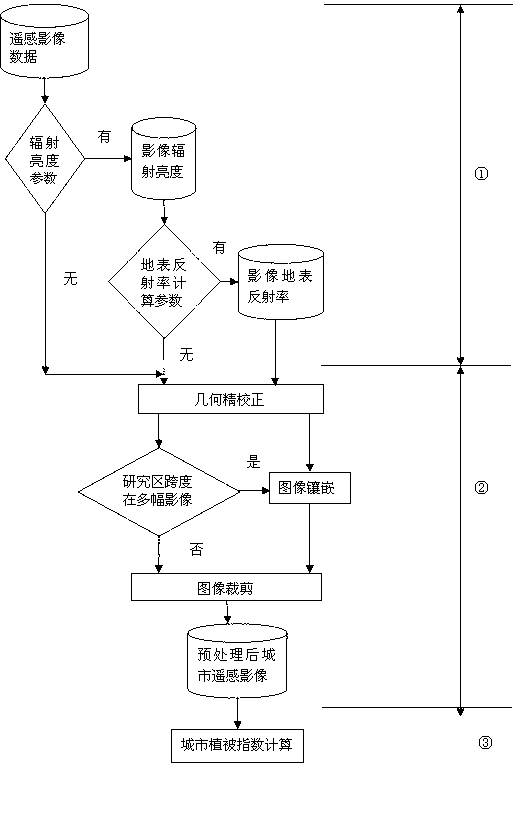
[0042] A kind of vegetation index construction method that is applied to city of the present invention, this method comprises the following steps:

[0043] (1) Radiometric correction of remote sensing images, such as figure 1 In ①, different degrees of radiation correction are performed according to the conditions of the acquired urban optical remote sensing images. If there are radiance calculation parameters, such as the Gain and Bias parameters of each band of the sensor, the remote sensing data can be calculated from the DN value of the remote sensing image data. The radiance value of the image; if there are further calculation parameters about the surface reflectance, the surface emissivity of the remote sensing image can be further calculated, and the radiation correction can improve the final retrieval accuracy of the terrain correction vegetation index. Therefore, the first step is based on the remote sensing image According to the specific situation, the result of su...


PUM


Abstract

The invention discloses a vegetation index construction method applied to a city. The method comprises the following steps of: (1) performing radiation correction at different degrees according to acquired city optical remote sensing image data, and thus acquiring city remote sensing image data which is subjected to the radiation correction; (2) performing geometrical fine correction, embedding and cutting preprocessing on the city optical remote sensing image data which is subjected to the radiation correction, and thus acquiring a preprocessed city remote sensing image; and (3) calculating the vegetation index IVI of the preprocessed city remote sensing image. By the method, the influence of city building land and water bodies can be well restrained, vegetation information can be enhanced, and the method is suitable for remote sensing image data acquired by a sensor without ground scaling parameters. A city vegetation index constructed by the method can accurately, quickly and precisely reflect the vegetation information of the city.

Description

technical field [0001] The invention relates to a method for constructing a vegetation index applied to cities. Background technique [0002] Urban land use types are very complex. Vegetated land is the most important member of the urban ecological environment system, and changes in its area and distribution will have a significant impact on the urban ecological environment. Therefore, it is of great significance to accurately obtain and understand the vegetation information and its spatial distribution characteristics in the city, and quantitatively study its impact on the urban ecological environment. . Due to the high density and complex landforms of urban vegetation in optical remote sensing images, the accuracy of remote sensing quantitative inversion of urban vegetation information is seriously affected. [0003] The current inversion of optical remote sensing vegetation information mainly adopts the method of vegetation index. The most commonly used vegetation inde...

Claims


Application Information

Patent Timeline
Patent Type & Authority Applications(China)
IPC IPC(8): G06F19/00
Inventor 谢亚楠刘文渊张洪万智龙木红柳
Owner SHANGHAI UNIV
Why Eureka
Try Eureka