Sea ice parameter extraction method on basis of satellite image

A technology for parameter extraction and satellite imagery, applied in instruments, character and pattern recognition, computer parts, etc., can solve problems such as low efficiency and error, and achieve the effect of ensuring accuracy, design specifications, and friendly interface

Active Publication Date: 2012-10-03
DALIAN UNIV OF TECH
View PDF2 Cites 28 Cited by
  • Summary
  • Abstract
  • Description
  • Claims
  • Application Information

AI Technical Summary

Problems solved by technology

[0003] Although satellite technology can be used to collect a large number of high-resolution satellite sea ice images, in post-processing, artificial methods are usually used to judge ice conditions
This method is extremely inefficient and has certain errors, and it is impossible to obtain accurate data of ice conditions through satellite images

Method used


Image

  • Sea ice parameter extraction method on basis of satellite image
  • Sea ice parameter extraction method on basis of satellite image
  • Sea ice parameter extraction method on basis of satellite image

Examples


Embodiment Construction

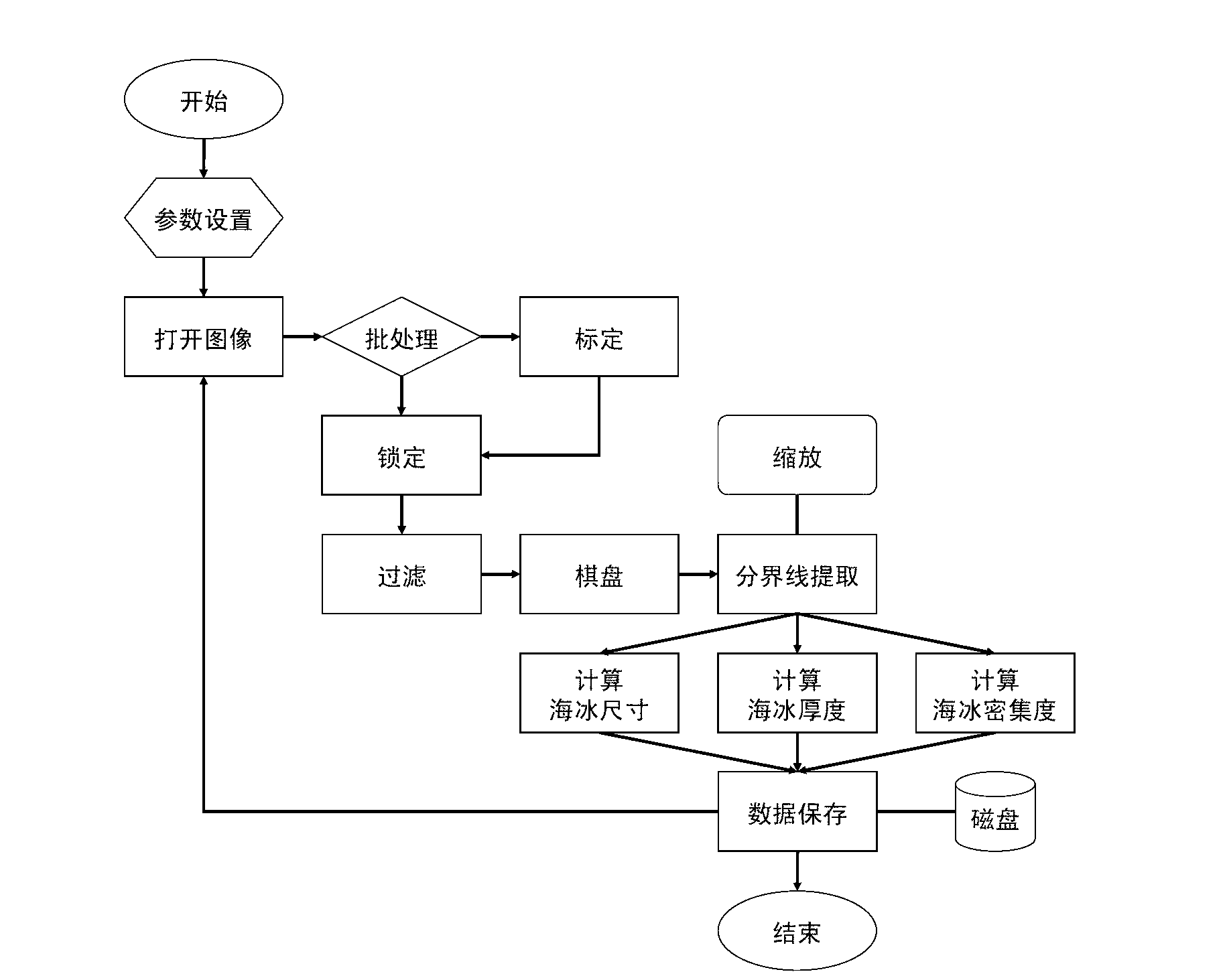
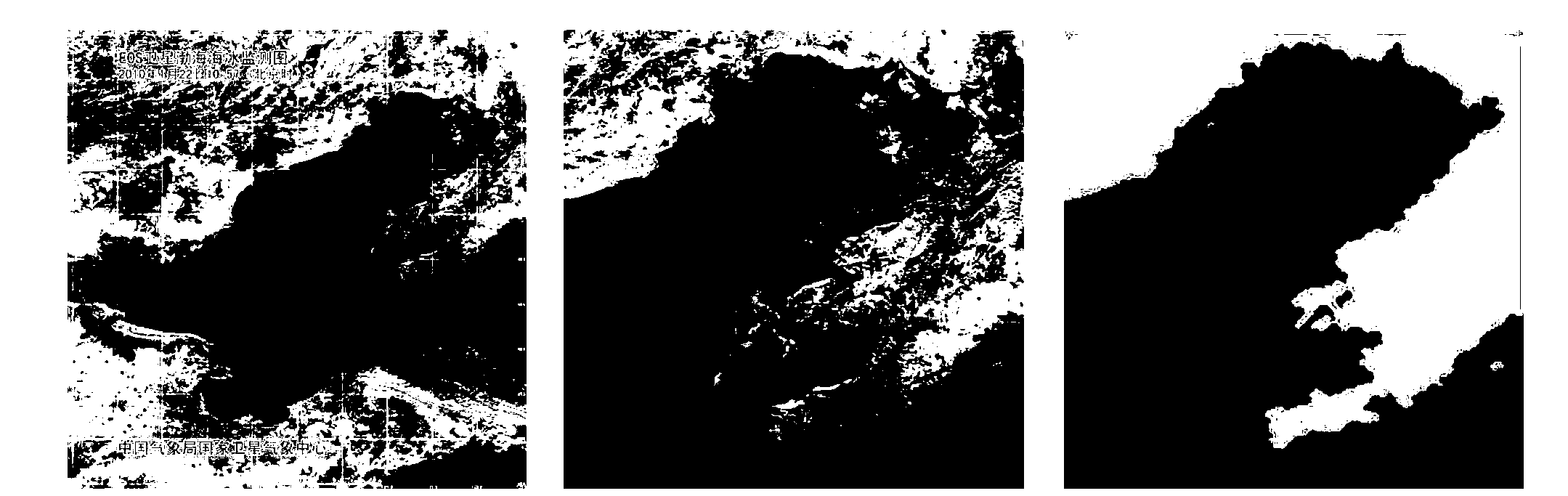
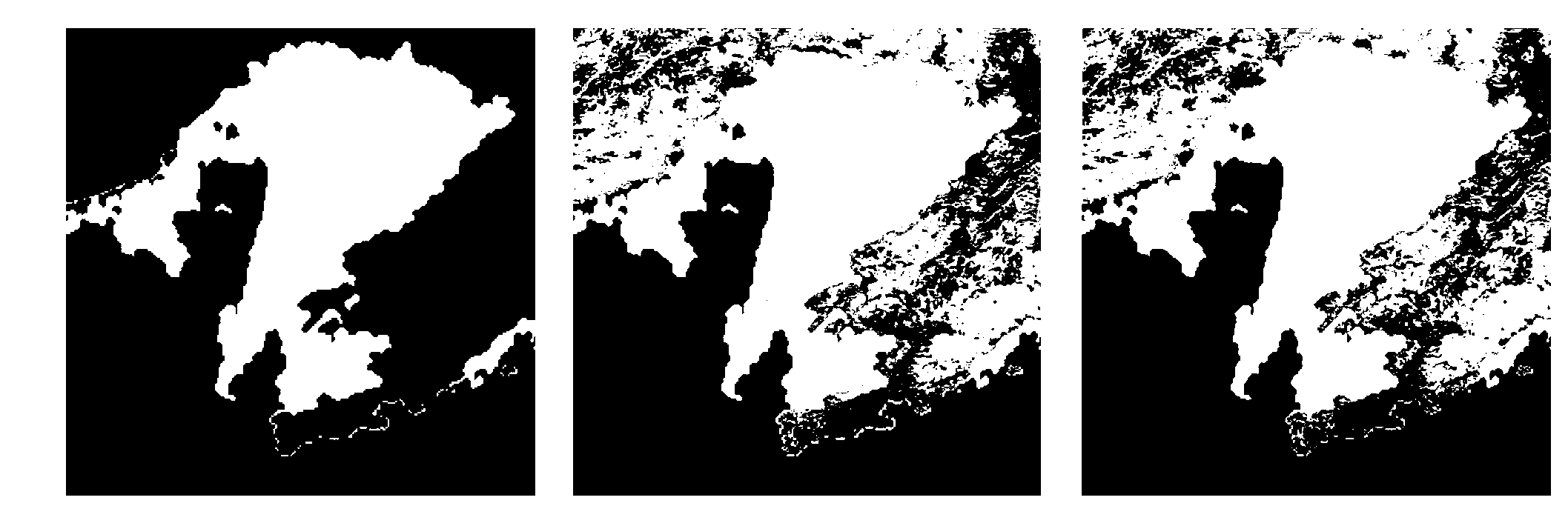
[0024] Attached with instructions figure 2 The satellite sea ice image shown as an example, set the land color feature to (R: 60-255, G: 0-255, B: 0-255), and set the sea water color feature to (R: 35-50 , G: 35-51, B: 40-80), the other color pixels are set as sea ice color characteristics. When calculating the area of ​​the area, assuming that the earth is a true sphere, first calculate the horizontal distance between two diagonal points by longitude, then calculate the horizontal distance by the center angle of the latitude line, and finally calculate the spherical area by integrating it.

[0025] After the user opens the image, click on the rectangle formed by the two points at the upper left corner and the lower right corner of the area of ​​interest as the area of ​​interest and generate a new image. During image denoising, if it is determined that a certain point in the image is a longitude line, the average value of the pixel colors (RGB color space) of the left and right...


PUM


Abstract

The invention relates to implementation of a sea ice parameter extraction method on the basis of a satellite image and a system and belongs to the technical field of computer application. The sea ice parameter extraction method on the basis of the satellite image is characterized in that an algorithm of eliminating warp and weft noise by the satellite image is implemented; image element types are accurately identified and classified; and a land and sea ice boundary and a sea ice and seawater boundary are extracted by a boundary tracing algorithm. On the basis, three parameters, i.e. the sea ice intensity, the sea ice thickness and the sea ice size, in the satellite image are calculated; and a user opens the image at a computer terminal and carries out the operations of preprocessing the image, identifying key elements (sea ice, land, seawater), describing the boundaries, extracting the sea ice parameters and storing a data result. The extraction method is reasonable, efficient and accurate and strong in scientificity; and the system is regular in design, high in reliability and user-friendly.

Description

Technical field [0001] The invention belongs to the field of computer application technology, and relates to an image processing method for sea ice satellite images, and particularly relates to a method for eliminating satellite image latitude and longitude noise, identifying key elements, and extracting boundary lines by computer means. By integrating relevant data structures and algorithms, sea ice density, thickness and size parameters can be extracted accurately and efficiently from sea ice satellite images. Background technique [0002] Ice condition monitoring and forecasting technology plays an extremely important role in safe production operations in cold regions. Satellite detection technology has been widely used in sea water monitoring in cold regions due to its wide detection range and high efficiency. For example, the EOS satellite used by the National Satellite Meteorological Center of my country can realize continuous real-time monitoring of the whole ice period i...

Claims


Application Information

Patent Timeline
Patent Type & Authority Applications(China)
IPC IPC(8): G06K9/46
Inventor 王宇新季顺迎郭禾刘宗勋
Owner DALIAN UNIV OF TECH
Why Eureka
Try Eureka