GIS (Geographic Information System)-based vehicle-mounted recorder for monitoring vehicle

A vehicle-mounted recorder and vehicle monitoring technology, which is applied in the registration/indication of vehicle operation, instruments, registration/instruction, etc., can solve the problem that the vehicle-mounted recorder device has not been publicized, and achieves complete functions, advanced technology, and improved statistical efficiency. Effect

Inactive Publication Date: 2012-10-03
新疆亚泰信息技术有限公司
View PDF5 Cites 11 Cited by
  • Summary
  • Abstract
  • Description
  • Claims
  • Application Information

AI Technical Summary

Problems solved by technology

[0007] It can be seen from this that the system or method for implementing vehicle management using GIS technology, especially, the key part of this technology, that is, the vehicle recorder device with satellite positioning and remote monitoring functions has not yet been made public.

Method used


Image

  • GIS (Geographic Information System)-based vehicle-mounted recorder for monitoring vehicle
  • GIS (Geographic Information System)-based vehicle-mounted recorder for monitoring vehicle

Examples


Embodiment Construction

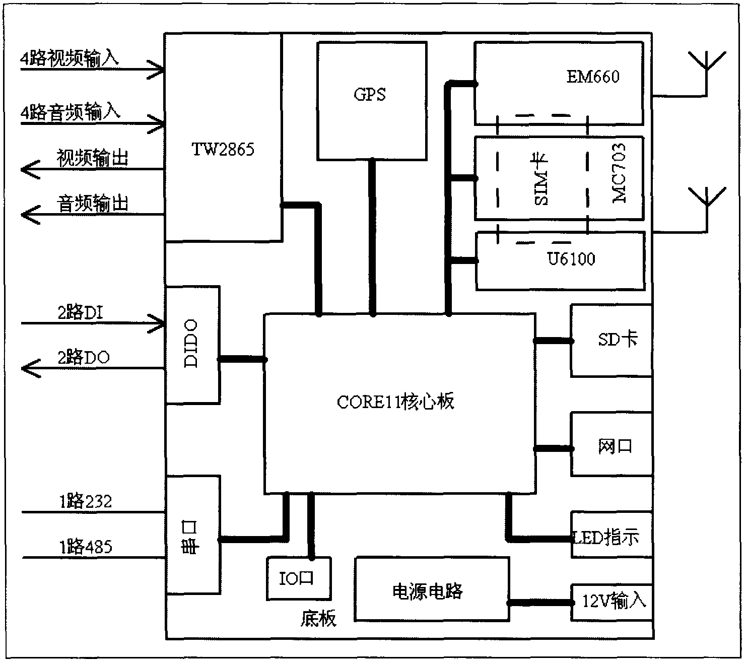
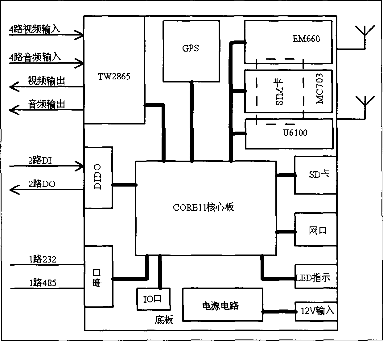
[0013] The invention consists of a core board, a GPS module, a power supply circuit, a vehicle-mounted encoder, and a 3G network card. The power supply circuit has a 12V input, and the core board is connected to the GPS module, the power supply circuit, the vehicle-mounted coder, and the 3G network card.

[0014] The core board is connected to the LED indicator, SD card, network port, serial port, IO port, and DIDO port. Among them, the serial port includes 1 channel 232 and 1 channel 485, and the DIDO port includes 2 channels of DO and 2 channels of DI.

[0015] The 3G network card is Telecom 3G network card EM660, network type: CDMA 2000 1xEV-DO(3g), maximum transmission speed: 3100Kbps, interface type: mini PCI-E, operating system: Windows 2000 / Windows XP / Windows Vista / Windows 7 / Linux 2.6.18or later versions, power consumption: <3.3W, 3G network card is connected with Huawei CDMA 1x EVDO3G module MC703.

[0016] The core board adopts ARM+DSP dual-core processor.

[0017] ...


PUM


Abstract

The invention relates to a GIS (Geographic Information System)-based vehicle-mounted recorder for monitoring a vehicle, which consists of a core plate, a GPS (Global Positioning System) module, a power supply circuit, a vehicle-mounted coder and a 3G (the 3rd Generation) network card. The power supply circuit is input by 12V, and the core plate is respectively connected with the GPS module, the power supply circuit, the vehicle-mounted coder and the 3G network card. Scientific means are provided for analysis and decision of online real-time monitoring and management of the vehicle by combining real-time vehicle tracks and work state data information obtained by a monitoring network consisting of a central processing unit and a vehicle-mounted wireless communication detector by means of strong spatial inquiring analyzing and pattern visualizing function of the GIS. The invention not only can position the vehicle precisely, playbacks and displays the information by the map and coverage loading function of the GIS, but also can inquire and display full-time dynamic data of the vehicle, and analyzes the path by means of the spatial inquiring analyzing and thematic map preparing function of the GIS, thereby improving the statistical efficiency of data of environmental sanitary vehicles in various forms.

Description

technical field [0001] The invention relates to the processing method of international patent classification G06F electrical digital data or G08G traffic control system, especially the GIS-based vehicle monitoring vehicle recorder. Background technique [0002] In the known technology, the number of urban vehicles increases rapidly, and more and more acts such as illegal driving, throwing along the way, and illegal dumping have also occurred thereupon, which has damaged environmental sanitation and endangered the interests of the public. However, there has been no effective way to solve this problem. [0003] As an important tool, technology and discipline for acquiring, storing, analyzing and managing geospatial data, geographic information system has received extensive attention and rapid development in recent years. [0004] GIS stands for Geographic Information System, which is based on geospatial database, with the support of computer software and hardware, and uses th...

Claims


Application Information

Patent Timeline
IPC IPC(8): G07C5/08
Inventor 智勇
Owner 新疆亚泰信息技术有限公司
Why Eureka
Try Eureka