Real-time mountain landslide monitoring method based on computer vision

A technology of computer vision and landslides, applied in the direction of measuring devices, instruments, optical devices, etc., can solve the problems of measurement influence, satellite signals are easily blocked, and the laying of sensing optical fibers is difficult, so as to achieve the real effect

Inactive Publication Date: 2012-10-10
NANCHANG HANGKONG UNIVERSITY
View PDF5 Cites 47 Cited by
  • Summary
  • Abstract
  • Description
  • Claims
  • Application Information

AI Technical Summary

Problems solved by technology

This method has the advantages of anti-electromagnetic interference, long-distance detection, and high sensitivity. The disadvantage is that it is difficult to lay the sensing optical fiber, and the landslide monitoring is based on the deformation of the cable. If the cable is not deformed and damaged, it is difficult to monitor the landslide. displacement
The GPS method is based on coordinates, distances and angles, and uses the difference between the new value and

Method used


Image

  • Real-time mountain landslide monitoring method based on computer vision

Examples


specific Embodiment approach

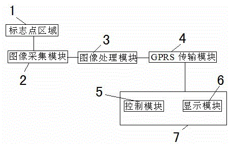
[0031] Specific implementation steps two: The construction method of the binocular stereo vision system in the real-time monitoring method of landslides based on computer vision has the following aspects:

[0032] (1) Fix the two cameras and keep them parallel to the front as much as possible;

[0033] (2) Calibrate the left and right cameras respectively, and obtain the camera internal parameter matrix and distortion vector;

[0034] (3) Stereo calibration, obtain the rotation matrix and translation vector between the left and right cameras.

[0035] Specific implementation steps three: The rough positioning method of the marker points of the landslide real-time monitoring method based on computer vision is as follows:

[0036] (1) read in the collected RGB image and convert it into HSI color space;

[0037] (2) Segment the color of the marker point, and binarize the image;

[0038] (3) Extract the target contour in the binary image, and use the shape criterion to remove...


PUM


Abstract

Disclosed is a real-time mountain landslide monitoring method based on computer vision. Firstly, image information of a laid marking point area is acquired by an image acquisition module; secondly, an image is analyzed in an image processing module, and image analysis induces image preprocessing, identification of marking points and mountain landslide displacement judgment; displacement information is returned to a monitoring center by a GPRS (general packet radio service) transmission module if landslide is judged, the monitoring center gives an alarm, the acquisition frequency of the image acquisition module is accelerated, and acquired scene pictures are returned to the monitoring center by the GPRS (general packet radio service) transmission module and are displayed on a display module of the monitoring center; and the image acquisition module continues to wait for acquiring information if the mountain landslide displacement is judged safe. The real-time mountain landslide monitoring method can be used for monitoring mountain landslide in real time, is used for catching valuable information before a mountain loses stability, and is simple, convenient and fast in layout.

Description

technical field [0001] The real-time monitoring method of landslides based on computer vision belongs to the category of computer vision, photogrammetry and embedded research. The main technical fields involve stereo vision measurement, identification of landmarks and wireless transmission. Background technique [0002] Landslides are one of the most common geological disasters in mountainous areas and along railways and highways. They seriously threaten people's lives and property, destroy engineering facilities, affect normal production and life, and cause huge economic losses and casualties. The traditional landslide monitoring is mainly to obtain the safety status of the landslide by summarizing the manual timing reading data after arranging fixed sensors or instruments on site. The landslide may have already been destroyed after data collection, so it is impossible to predict the landslide situation in a timely and accurate manner. The biggest disadvantage is that it is...

Claims


Application Information

Patent Timeline
IPC IPC(8): G01B11/02
Inventor 曾接贤田波刘肖忠
Owner NANCHANG HANGKONG UNIVERSITY
Why Eureka
Try Eureka