Integrated satellite system for measuring global gravity field

A satellite system and gravity field technology, applied in the field of satellite systems, can solve the problems of poor time-varying measurement ability, large error, and low precision, and achieve the effects of strong time-varying ability, high precision, and good measurement effect

Active Publication Date: 2012-10-17
AEROSPACE DONGFANGHONG SATELLITE
View PDF1 Cites 17 Cited by
  • Summary
  • Abstract
  • Description
  • Claims
  • Application Information

AI Technical Summary

Problems solved by technology

The main manifestations are: although the GRACE satellite has time-varying measurement capabilities, the highest order of the earth's gravity field model is only 120, and the accuracy is relatively low; although the highest order of the earth's gravity field model retrieved by the GOCE satellite can reach 200 orders, But it is mainly for static measurement, the time-varying measurement ability is poor, and the error is large in the middle and low frequency parts
[0006] At present, there is no satellite system that has high-precision measurement capabilities in long-wave, medium-long-wave, and medium-short wave, and can perform time-varying and static measurements.

Method used


Image

  • Integrated satellite system for measuring global gravity field
  • Integrated satellite system for measuring global gravity field

Examples


Embodiment Construction

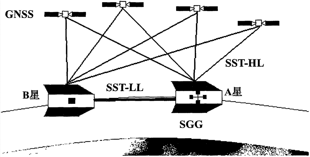
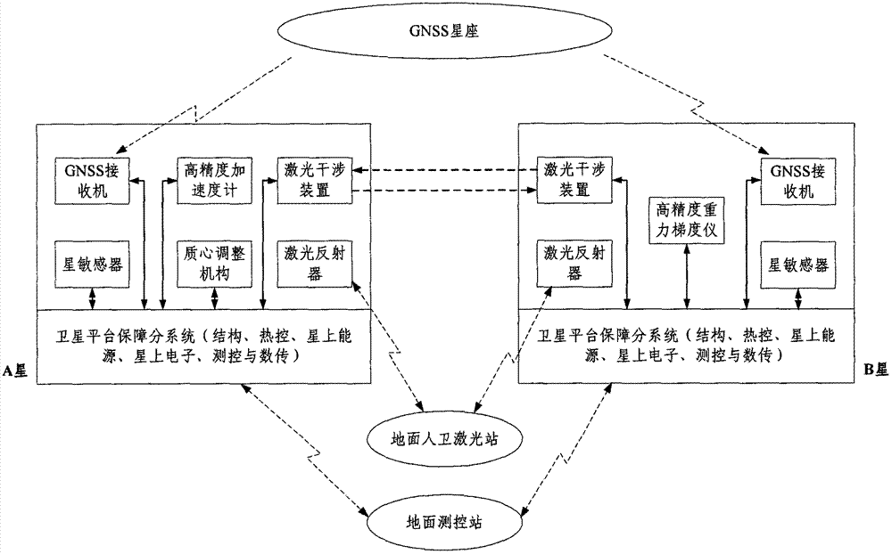
[0013] What the present invention proposes is a kind of novel integrated gravity field measurement satellite system, such as figure 1 As shown, the comprehensive measurement mode of "high-low satellite tracking (SST-HL) + low-low satellite tracking (SST-LL) + satellite gravity gradient (SGG)" is adopted.

[0014] (1) Satellite orbit and main payload

[0015] The satellite system consists of two satellites (referred to as A star and B star) forming a formation, flying in the same near-circular orbit in the way of back-to-back flight. The orbit height should generally be below 300km, and the distance between two stars should generally be below 100km, which can be adjusted according to specific goals.

[0016] Dual-frequency GNSS receivers (Global Navigation Satellite System) are installed on the two satellites, and one or more of the GPS navigation satellite system, GLONASS navigation satellite system, Galileo navigation satellite, and Beidou navigation satellite system constit...


PUM


Abstract

The invention relates to an integrated satellite system for measuring a global gravity field. The system comprises two satellites which fly on the same nearly polar and nearly circular orbit in a following mode, wherein each of the two satellites is loaded with a double-frequency global navigation satellite system (GNSS) receiver besides a satellite platform guarantee subsystem; a high-low satellite tracking satellite link consists of the two satellites and a high orbit navigation satellite system and is used for determining a satellite orbit at high accuracy and acquiring long wave band information of an earth gravity field, which is contained in satellite orbit information; meanwhile, the two satellites are loaded with high-accuracy laser interference distance measurement devices, and a low-low satellite tracking satellite link is formed through laser interference and used for acquiring medium-long wave band information of the earth gravity field, which is contained in a laser interference signal; and in addition, one satellite is loaded with a high-accuracy gravity gradiometer for satellite gravity gradient measurement, and a measurement output signal contains the medium-long wave band information of the earth gravity field, so that the global time-variant and static gravity field measurement of long waves, medium-long waves and medium-short waves is finished.

Description

technical field [0001] The invention relates to a satellite system for measuring the high-precision global gravitational field of the earth, in particular to a satellite system capable of performing high-precision global time-varying and static gravitational field measurement in long-wave, medium-long-wave, and medium-short wave simultaneously. Background technique [0002] The Earth's gravity field reflects the spatial distribution, movement, and changes of Earth's materials. Determining the fine structure and changes of the Earth's gravity field can provide important basic geoscience information for further understanding the Earth and solving urgent problems facing human beings such as resources, environment, and disasters. [0003] Compared with ground, ocean, and aviation earth gravity field measurements, satellite gravity field measurements have the characteristics of high precision, high efficiency, and global coverage. Typical representatives are CHAMP satellites, GRAC...

Claims


Application Information

Patent Timeline
Patent Type & Authority Applications(China)
IPC IPC(8): G01V7/00
Inventor 丁延卫张晓敏马林
Owner AEROSPACE DONGFANGHONG SATELLITE
Why Eureka
Try Eureka