Spatial data partitioning method in cloud environment

A technology of spatial data and cloud environment, applied in the field of computer networks, can solve the problems of not satisfying the principle of data volume balance, not proposing construction, and low efficiency, and achieve the effects of improving indexing efficiency, good real-time performance of algorithms, and low computational complexity

Inactive Publication Date: 2013-01-30
NANJING UNIV OF POSTS & TELECOMM
View PDF0 Cites 9 Cited by
  • Summary
  • Abstract
  • Description
  • Claims
  • Application Information

AI Technical Summary

Problems solved by technology

This method does not satisfy the principle of data volume balance, k The mean clustering algorithm can only ensure that spatially adjacent objects are in the same family, but it cannot guarantee that the size of each family is relatively balanced
[0007] Liu Runtao et al proposed to use k Means Clustering Algorithm Establishment R The

Method used


Image

  • Spatial data partitioning method in cloud environment

Examples


Embodiment Construction

[0019] The technical scheme of the present invention is described in detail below in conjunction with accompanying drawing:

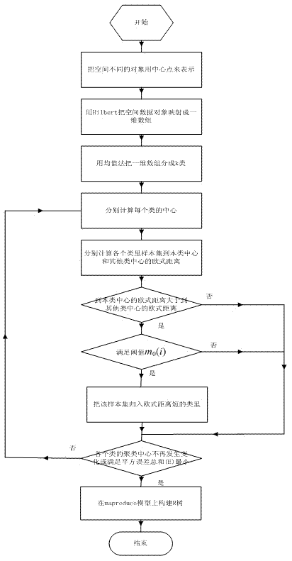
[0020] When establishing the R-tree index structure of geospatial data in the cloud environment, the division of spatial data objects should make R The tree satisfies the data volume balance criterion and the space relationship balance criterion of spatial data object division. As introduced in the background technology, the existing partition method of the mean method does not satisfy the principle of spatial relationship balance, that is, the partition cannot guarantee that the spatially adjacent objects are in the R On the same branch of the tree, so that the index efficiency is reduced; and k Although the mean clustering algorithm satisfies the principle of spatial relationship balance, it cannot satisfy the criterion of data volume balance. In order to solve this problem, the idea of ​​the present invention is to use the Hilbert curve encoding me...


PUM


Abstract

The invention discloses a spatial data partitioning method in a cloud environment, belonging to the technical field of computer networks. The method comprises the steps of firstly, uniformly partitioning a spatial data object by using a Hilbert curve coding method, and secondly partitioning adjacent spatial data objects into one type as far as possible by using an improved k-mean value clustering algorithm based on the first step. According to the spatial data partitioning method, the advantages of a conventional mean value method and a k-mean value clustering algorithm are synthesized, the standard in spatial data partitioning is met well, geographic spatial data can be uniformly distributed to map-reduce to be processed so as to establish an R-tree, so that the geographic spatial data index efficiency is improved. And moreover according to the method, the calculation complexity is low and the real-time capability of the algorithm is good.

Description

technical field [0001] The invention relates to a spatial data division method in a cloud environment, belonging to the technical field of computer networks. Background technique [0002] Cloud computing is a distributed system that can distribute computing tasks to multiple machines for processing, and can provide computing power, storage space and information services to various application systems. Now google Companies and Open Source Cloud Computing Platforms hadoop etc. are used map-reduce Parallel Computing Model. This model provides a general and efficient technical framework for the processing of massive data, so it has been more and more widely used in geospatial data query processing, data mining and other fields. [0003] Today, improving the efficiency of geospatial data indexing is a hot issue, and how to find an effective method to build an indexing mechanism on the cloud platform is of great significance. R The tree is a height-balanced tree, using the ...

Claims


Application Information

Patent Timeline
IPC IPC(8): G06F17/30
Inventor 刘林峰孙靖吴家皋邹志强
Owner NANJING UNIV OF POSTS & TELECOMM
Why Eureka
Try Eureka