Semi-automatic classification method for timing sequence remote sensing images based on continuous wavelet transforms

A wavelet transform, remote sensing image technology, applied in instruments, character and pattern recognition, computer parts and other directions, can solve the problems of affecting classification accuracy and efficiency, unable to extract completely and effectively, limited information dimension, etc., to achieve good robustness With the effect of adaptability, rich information dimension, and high degree of automation

Inactive Publication Date: 2013-03-20
FUZHOU UNIV
View PDF2 Cites 9 Cited by
  • Summary
  • Abstract
  • Description
  • Claims
  • Application Information

AI Technical Summary

Problems solved by technology

The disadvantage of the first type of method is that it is very dependent on the experience of the user and the quality of the single-phase image data itself, and due to the limited dimension of information, the phenomenon of the same object with different spectra and different objects with the same spectrum is very common, and has become an in-depth application. The biggest bottleneck; the advantages of the second type of method are obvious, but because the method is not proposed for a long time, it is in the development stage, and more in-depth research work is needed
However, each different type of ground object has its characteristics in multiple dimensions such as different scale dimensions and time dimensions. The above methods cannot extract these features completely and effectively, which affects the accuracy and efficiency of classification.

Method used


Image

  • Semi-automatic classification method for timing sequence remote sensing images based on continuous wavelet transforms
  • Semi-automatic classification method for timing sequence remote sensing images based on continuous wavelet transforms

Examples


Embodiment Construction

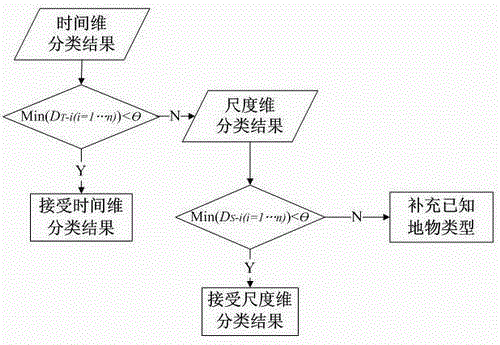
[0016] The present invention is based on continuous wavelet transform time-series remote sensing image semi-automatic classification method, comprises the following steps:

[0017] Step 1: Based on a series of remote sensing image datasets with time-series changes within a certain time step interval, establish the original maps of the time-series changes in the year for several known ground objects, such as the original maps of the time-series changes in the year for several crops based on the MODIS EVI index. As the prior knowledge and basis for semi-automatic classification of remote sensing images;

[0018] Step 2: Based on the Morlet wavelet and the Mexican hat wavelet respectively, perform continuous wavelet transform on the original map of the time-series variation of the known ground objects within a year, and obtain the wavelet coefficient spectrum based on the Morlet wavelet transform and the wavelet coefficient spectrum based on the Mexican hat wavelet transform; the ...


PUM


Abstract

The invention relates to a semi-automatic classification method for timing sequence remote sensing images based on continuous wavelet transforms. The semi-automatic classification method first builds a plurality of within-a-year sequential variation initial maps of known surface features, conducts continuous wavelet transforms on the within-a-year sequential variation initial maps, and then obtains wavelet coefficient maps and on this basis builds wavelet variance maps based on time dimension and wavelet variance maps based on scale dimension. Meanwhile, wavelet variance maps based on time dimension and wavelet variance maps based on scale dimension of all the research units in the whole research area are built, and then the optimum time domains and the optimum scale domains for images classification are respectively confirmed according to an inter-class otherness maximization principle of the wavelet variance maps of known surface features, and finally semi-automatic classification of remote sensing images is achieved through building a comprehensive evaluation system. The semi-automatic classification method can effectively draw the characteristics of timing sequence remote sensing images in time dimension and scale dimension and has the advantages of being less in reliable on prior knowledge, good in robustness, high in classification accuracy, high in the degree of automation and the like.

Description

technical field [0001] The invention relates to the technical field of remote sensing image information processing, in particular to a semi-automatic classification method for time-series remote sensing images based on continuous wavelet transform. Background technique [0002] At present, satellite remote sensing systems such as MODIS can provide daily remote sensing image data covering the whole world, providing a detailed data basis for monitoring the characteristics of land cover changes. How to reasonably use the timing information of remote sensing images for automatic and semi-automatic classification is a very important task. Remote sensing image classification methods can be roughly divided into two categories: the first category is the traditional algorithm based on the idea of ​​spatial clustering, many commonly used algorithms belong to this type, such as maximum likelihood discriminant method, neural network classification method, fuzzy classification method me...

Claims


Application Information

Patent Timeline
Patent Type & Authority Applications(China)
IPC IPC(8): G06K9/62
Inventor 邱炳文钟鸣
Owner FUZHOU UNIV
Why Eureka
Try Eureka