Method for calculating sea ice thickness based on hyperspectral remote sensing reflectance

A technology of remote sensing reflectance and hyperspectral remote sensing, applied in the field of sea ice thickness calculation, can solve the problems of low time and space resolution, affecting the calculation and monitoring of sea ice thickness, and achieve the effect of simple method

Inactive Publication Date: 2013-04-03
THE FIRST INST OF OCEANOGRAPHY SOA +1
View PDF1 Cites 11 Cited by
  • Summary
  • Abstract
  • Description
  • Claims
  • Application Information

AI Technical Summary

Problems solved by technology

However, the above research involves the calculation of sea ice thickness from the wide-band remote sensing data of spaceborne ocean optical remote sensors, and its temporal and spatial resolution is low, which affects the calculation and monitoring of sea ice thickness

Method used


Image

  • Method for calculating sea ice thickness based on hyperspectral remote sensing reflectance
  • Method for calculating sea ice thickness based on hyperspectral remote sensing reflectance
  • Method for calculating sea ice thickness based on hyperspectral remote sensing reflectance

Examples


Embodiment 1

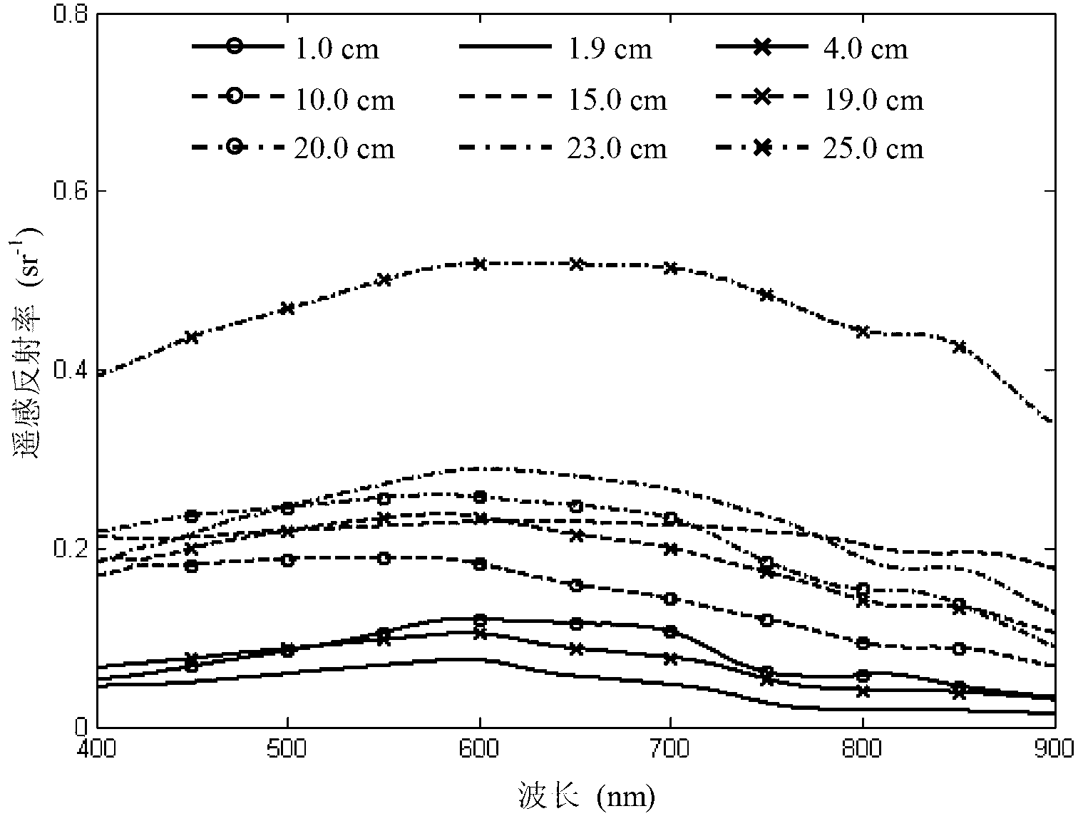
[0030] The sea ice thickness is calculated by using the remote sensing reflectance obtained from the on-site measurement of natural sea ice by ground object spectrometer. The measured thickness of sea ice is 1.0cm, 1.9cm, 4.0cm, 9.5cm, 10.0cm, 15.0cm, 19.0cm, 20.0cm, 23.0cm, 25.0cm.

[0031] From the hyperspectral remote sensing reflectance spectrum of sea ice, the remote sensing reflectance with wavelengths of 572nm, 585nm, 702nm, 744nm and 880nm is selected, and the calculated sea ice thickness is shown in the table below.

[0032] Measured value (cm)

Calculated value (cm)

Absolute error(cm)

Relative error(%)

1.0

1.0

0.0

0.00

1.0

1.4

0.4

40.00

1.9

1.7

0.2

10.53

1.9

1.4

0.5

26.32

4.0

4.9

0.9

22.50

4.0

4.7

0.7

17.50

9.5

12.4

2.9

30.53

9.5

13.8

4.3

45.26

10.0

8.6

1.4

14.00

15.0

...

Embodiment 2

[0040] For the sea ice frozen under laboratory conditions, the remote sensing reflectance data is obtained by measuring the surface object spectrometer, and the thickness is calculated. The measured thickness of sea ice is 6.5cm, 10.0cm, 20.0cm and 32.0cm, respectively.

[0041] From the remote sensing reflectance spectrum of sea ice, select the remote sensing reflectance with wavelengths of 572nm, 585nm, 702nm, 744nm and 880nm, and substitute them into the sea ice thickness calculation model to calculate the thickness of sea ice.

[0042] Measured value (cm)

[0043] After testing, the correlation coefficient R between the measured value of sea ice thickness and the calculated value of the model 2 =0.97, average relative error APD=28.7%, root mean square error RMS=3.3cm, less than 4.0cm.

Embodiment 3

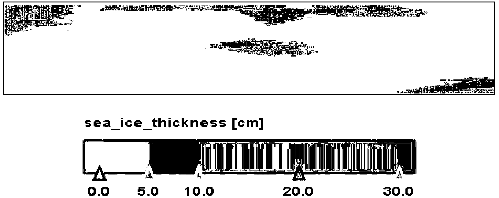
[0045] Using aerial hyperspectral images of sea ice in Liaodong Bay in winter (such as figure 2 ) to calculate sea ice thickness. First calculate the digital quantization value of the original image If it is less than 3.54, the sea ice pixel is identified; then geometric correction, radiation correction and atmospheric correction are performed on the aerial hyperspectral image to obtain the remote sensing reflectance; The albedo is substituted into the calculation model of sea ice thickness, and the calculated spatial distribution of sea ice thickness is shown in image 3 , the distribution range of ice thickness is 1.0~25.0cm, and the calculated results are reasonable.

[0046] In summary, the present invention uses on-site and laboratory-measured sea ice hyperspectral data to calculate sea ice thickness, and its root mean square error is within 4.0cm; using aerial hyperspectral images to calculate sea ice thickness, the calculated The result is reasonable.


PUM


Abstract

The invention relates to a method for calculating sea ice thickness based on hyperspectral remote sensing reflectance. The method comprises the following steps of selecting the ratio of remote sensing reflectance of different wavelengths and functions as the characteristics of determining the sea ice thickness according to the different thicknesses of sea ice hyperspectral remote sensing reflectance; building a sea ice thickness calculation model to obtain the sea ice thickness; aiming at an aerial hyperspectral image containing sea ice, firstly, utilizing the ratio of digital quantization values of an image to identify a sea ice picture element; carrying out radiation correction and atmospheric correction on the digital quantization values of the image according to the common aerial hyperspectral image processing method to obtain the hyperspectral remote sensing reflectance of the sea ice picture element; and finally substituting into the sea ice thickness calculation model, and calculating the thickness of the sea ice picture element. The model disclosed by the invention is simple; and only remote sensing reflectance Rrs of finite wavelengths is selected. Therefore, sea ice thickness calculation of the sea ice remote sensing reflectance measured by a spectroradiometer is achieved, and calculation of the sea ice thickness by the aerial hyperspectral remote sensing image is also achieved.

Description

technical field [0001] The invention relates to a method for calculating sea ice thickness based on hyperspectral remote sensing reflectance. Background technique [0002] Sea ice is one of the natural elements of the earth's surface. The extent and thickness of sea ice are important input parameters for global energy balance, climate, hydrology, and ecological models. The Bohai Sea is the sea area with the highest latitude in my country. Every winter, the Bohai Sea freezes to varying degrees, which makes the Bohai Sea the sea area with the heaviest sea ice in my country. [0003] Among various sea ice parameters, sea ice thickness is a key indicator for ice volume estimation, ice situation assessment, and disaster assessment, and is a factor of great concern to marine traffic management in winter; moreover, sea ice thickness is closely related to climate change and is an The main factors of exchange, especially the newly formed thin ice are the key factors controlling the ...

Claims


Application Information

Patent Timeline
Patent Type & Authority Applications(China)
IPC IPC(8): G01B11/06
Inventor 秦平崔廷伟范学炜牟冰沈钺赵海峰倪绍起刘振宇任广波马毅张汉德
Owner THE FIRST INST OF OCEANOGRAPHY SOA
Why Eureka
Try Eureka