Inertial and celestial combined navigation method based on star coordinate modeling

A technology of integrated navigation and star image coordinates, which is applied in the field of integrated navigation and can solve problems such as dissatisfaction, deterioration of navigation star geometry, and impact on combined filtering performance.

Active Publication Date: 2013-04-24
NANJING UNIV OF AERONAUTICS & ASTRONAUTICS
View PDF4 Cites 15 Cited by
  • Summary
  • Abstract
  • Description
  • Claims
  • Application Information

AI Technical Summary

Problems solved by technology

When the aero-optical effect of hypersonic flight makes part of the starlight information unusable, the geometric configuration of the visible navigation star deteriorates significantly, the attitude accuracy output by the star sensor changes drastically, and the noise characteristics of the attitude information do not satisfy the Kalman filter measurement noise is the requirement of white noise, and the conventional combination method will affect the combined filtering performance

Method used


Image

  • Inertial and celestial combined navigation method based on star coordinate modeling
  • Inertial and celestial combined navigation method based on star coordinate modeling
  • Inertial and celestial combined navigation method based on star coordinate modeling

Examples


Embodiment Construction

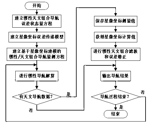
[0065] Below in conjunction with the accompanying drawings, a kind of inertial and astronomical integrated navigation method based on star image coordinate modeling proposed by the present invention will be described in detail:

[0066] An inertial and astronomical integrated navigation method based on star image coordinate modeling, the process flow of this method is shown in Figure 1, and its steps are:

[0067] 1) Establish the inertial and astronomical integrated navigation error state quantity equation

[0068] According to the error characteristics of inertial and astronomical integrated navigation, the error state quantity equation of inertial and astronomical integrated navigation is established from the mathematical description of the error of aviation airborne inertial navigation system. The state quantity X of inertial and astronomical integrated navigation error is defined as:

[0069] X = [ φ ...


PUM


Abstract

The invention provides an inertial and celestial combined navigation method based on star coordinate modeling. With the method, according to the difference in observed number of stars, inertial and celestial combination during multi-star observation is automatically realized, and star starlight measurement information application flexibility is improved. When star configurations are substantially deteriorated, characteristics of observation noises inputted into a Kalman filter are maintained stable, such that navigation performance under a situation with substantially reduced available navigation star number during high dynamic flight is improved. Compared with conventional inertial and celestial combined systems without the technology provided by the invention, the method provided by the invention has better adaptability to situation with deteriorated star configurations. Therefore, the method provided by the invention is suitable for engineering applications.

Description

technical field [0001] The invention belongs to the technical field of integrated navigation, and specifically refers to an inertial and astronomical integrated navigation method based on star image coordinate modeling. Background technique [0002] Integrated navigation is an effective way to improve the reliability and accuracy of the aircraft navigation system. The current inertial and satellite integrated navigation has been widely used in the navigation of various aircraft with good positioning performance, but its attitude accuracy is limited; in order to meet the requirements of the control system For the high-precision measurement of attitude, the attitude error can be corrected by astronomical navigation through the combination of starlight information observed by the star sensor. [0003] With the development of new aircraft, the extremely harsh environment caused by aerodynamic heating poses new problems for the application of celestial navigation systems. The ae...

Claims


Application Information

Patent Timeline
Patent Type & Authority Applications(China)
IPC IPC(8): G01C21/16G01C21/02
Inventor 王融熊智刘建业钟丽娜张承彭惠赵慧许建新刘伟霞王洁
Owner NANJING UNIV OF AERONAUTICS & ASTRONAUTICS
Why Eureka
Try Eureka