Satellite gravity inversion method based on load error analysis theory

A technology for satellite gravity inversion and payload error analysis, which is applied in cross-fields and can solve problems such as slow solution speed and high computer requirements

Inactive Publication Date: 2013-05-08
INST OF GEODESY & GEOPHYSICS CHINESE ACADEMY OF SCI
View PDF5 Cites 12 Cited by
  • Summary
  • Abstract
  • Description
  • Claims
  • Application Information

AI Technical Summary

Problems solved by technology

The advantage of the numerical method is that the calculation accuracy of the earth's gravity field is high; the disadvantage is that the solution speed is slow and the computer requirements are high

Method used


Image

  • Satellite gravity inversion method based on load error analysis theory
  • Satellite gravity inversion method based on load error analysis theory
  • Satellite gravity inversion method based on load error analysis theory

Examples


Embodiment Construction

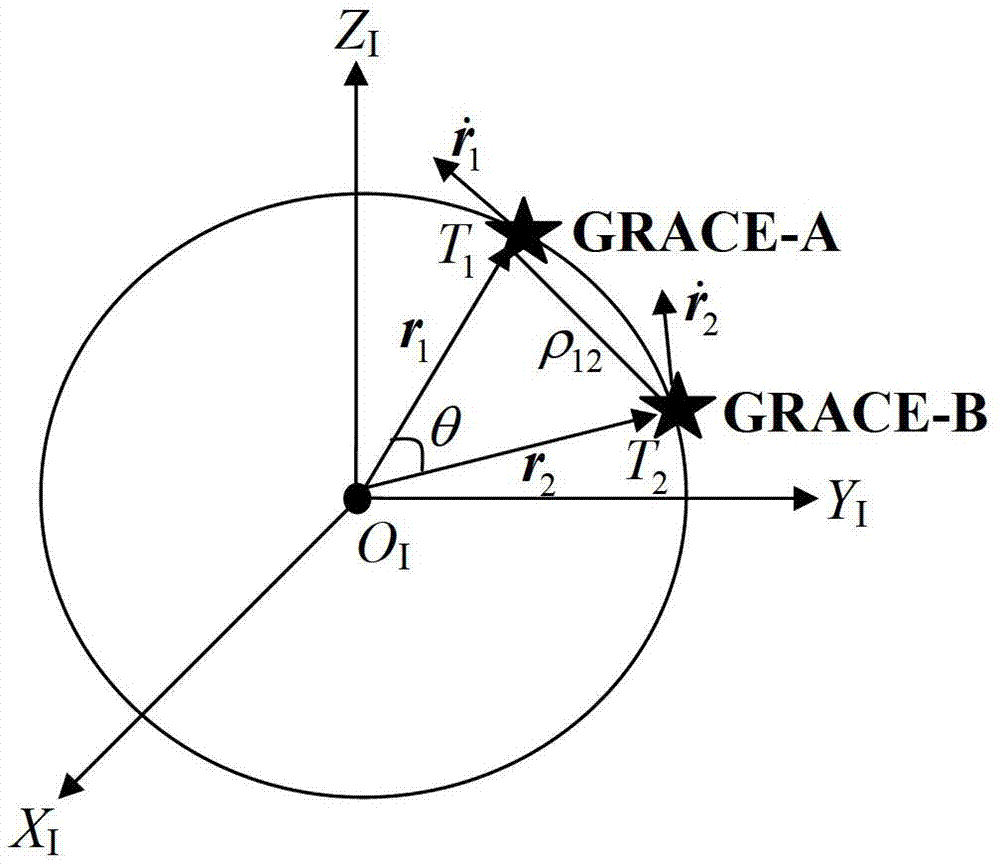
[0099] The specific implementation of the present invention will be further described below in conjunction with the accompanying drawings, taking the GRACE double star as an example.

[0100] Satellite gravity inversion method based on load error analysis principle:

[0101] Step 1: Satellite key payload data collection

[0102] 1.1) Obtain the inter-satellite distance error data δρ through the spaceborne K-band rangefinder 12 ;

[0103] 1.2) Obtain orbital position error data δr and orbital velocity error data through the spaceborne GPS receiver

[0104] 1.3) Obtain the non-conservative force error data δf through the on-board accelerometer.

[0105] Step 2: Establishment of key load error model

[0106] 2.1) Inter-satellite distance error model of K-band range finder

[0107] Based on the law of energy conservation, the satellite observation equation can be expressed as

[0108] 1 2 r · ...


PUM


Abstract

The invention relates to a method for accurately detecting the earth gravity field, in particular to a method which includes: based on the load error analysis theory, accurately building the distance error between satellites of a K wave band distance meter, the satellite orbit position error and the orbital velocity error of a global positioning system (GPS) receiver and an error model in which accumulative geoid accuracy is affected by the nonconservative force error coalition of a satellite-bone accelerometer, and further accurately and rapidly inversing the earth gravity field. The method is high in inversion accuracy of the earth gravity field, simple in satellite gravity inversion process, low in performance requirements of a computer and definite in physical meanings of a satellite observation equation, and effectively improves inversion speed on the premise of ensuring calculation accuracy. The satellite gravity inversion method based on the load error analysis theory is an effective method for calculating the earth gravity field which is high in accuracy and spatial resolution.

Description

1. Technical field [0001] The invention relates to intersecting technical fields such as satellite gravity, space geodesy, aerospace and the like, in particular to a method for accurately and quickly inverting the earth's gravity field based on the load error analysis principle. 2. Background technology [0002] The 21st century is a new era for human beings to use SST-HL / LL (Satellite-to-Satellite Tracking in the High-Low / Low-Low Mode) and SGG (Satellite Gravity Gradiometry) to improve their cognition of the digital earth. The earth's gravitational field and its time variation reflect the spatial distribution, movement and change of the earth's surface and interior materials, and at the same time determine the fluctuation and change of the geoid. Therefore, to determine the fine structure of the Earth's gravity field and its time-varying is not only a requirement for geodesy, geophysics, seismology, oceanography, space science, national defense construction, etc., but also ...

Claims


Application Information

Patent Timeline
Patent Type & Authority Applications(China)
IPC IPC(8): G01V7/00
Inventor 不公告发明人
Owner INST OF GEODESY & GEOPHYSICS CHINESE ACADEMY OF SCI
Why Eureka
Try Eureka