
geo orbit transfer vehicle sins/cns/gnss integrated navigation system

An integrated navigation system and orbit transfer technology, applied in the direction of navigation through speed/acceleration measurement, celestial navigation, navigation calculation tools, etc., can solve the problems of no description or report, no data collected, etc., to achieve high reliability, Strong autonomy and good robustness

Active Publication Date: 2016-02-10
SHANGHAI AEROSPACE SYST ENG INST
View PDF2 Cites 2 Cited by
  • Summary
  • Abstract
  • Description
  • Claims
  • Application Information

AI Technical Summary

Problems solved by technology

[0004] At present, there is no description or report of the similar technology of the present invention, and no similar data at home and abroad have been collected yet.

Method used


Image

  • geo orbit transfer vehicle sins/cns/gnss integrated navigation system
  • geo orbit transfer vehicle sins/cns/gnss integrated navigation system
  • geo orbit transfer vehicle sins/cns/gnss integrated navigation system

Examples


Embodiment Construction

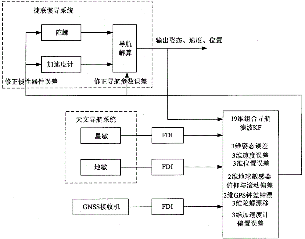
[0008] The present invention will be described in further detail below in conjunction with the accompanying drawings. figure 1 It is a block diagram of the SINS / CNS / GNSS integrated navigation system of the GEO orbit transfer aircraft of the present invention, which is composed of a strapdown inertial navigation system, a celestial navigation system, and a GNSSS receiver.

[0009] The strapdown inertial navigation system mainly calculates the attitude, position and velocity of the aircraft based on the output of the gyroscope and the accelerometer. The coordinate transformation matrix between the aircraft body coordinate system b and the equatorial inertial coordinate system i can be calculated by the gyro output according to the following formulas calculate.

[0010] C b ′ ( k ) = C b ′ ( k ...


PUM


Abstract

The invention provides an integrated navigation system of a strapdown inertial navigation system (SINS) / a central nervous system (CNS) / a global navigation satellite system (GNSS) of a geostationary earth orbit (GEO) transfer vehicle. The SINS serves as a core of the integrated navigation system. Navigation information of the GEO transfer vehicle is calculated and output by the SINS in real time, fault detection and isolation are conducted to data output by a GNSS receiver, a globe sensor and a star sensor by utilizing a residual error chi 2 detecting method improved by a kalman filter. Information fusion is conducted to output information of the globe sensor and the star sensor in a celestial navigation system, pseudorange measuring information output by the GNSS receiver and the navigation information output by the SINS. Navigation errors, inertial device errors, globe sensor errors and GNSS receiver time errors of the GEO transfer vehicle are evaluated in real time, and the navigation errors of the GEO transfer vehicle are corrected through a manner of closed loop feedback correction in real time so that in-orbit self navigation with high precision and high reliability of the GEO transfer vehicle is achieved, and therefore meaningful effects of good subjectivity, high precision, good robustness and high reliability are obtained.

Description

technical field [0001] The invention relates to the technical field of autonomous navigation of a GEO orbit transfer aircraft, in particular to an information fusion and fault-tolerant design technology applicable to a SINS / CNS / GNSS integrated navigation system of a GEO orbit transfer aircraft. Background technique [0002] At present, most of the space vehicles operating on the GEO orbit realize the navigation and orbit determination and the corresponding orbit maintenance control through the orbit forecast of the ground measurement and control system. One of the characteristics of the new GEO orbit transfer aircraft is that it can perform autonomous maneuvers in orbit, while the ground measurement and control orbit forecast can only predict the orbit of the aircraft based on the perturbed orbit dynamics. If the aircraft performs orbit change maneuvers during this period, the ground measurement and control The orbit forecast data cannot reflect the real orbit of the aircraf...

Claims


Application Information

Patent Timeline
Patent Type & Authority Patents(China)
IPC IPC(8): G01C21/16G01C21/20G01C21/02G01S19/47
Inventor 顾冬晴叶飚刘玉
Owner SHANGHAI AEROSPACE SYST ENG INST
Learn More