Navigation method based on polarization-geomagnetic vector tight integration

A navigation method and a tight combination technology, applied in the field of navigation based on the tight combination of polarization-geomagnetic vector, can solve the problem of not considering the deep fusion of geomagnetic information and polarization information, etc.

Active Publication Date: 2019-03-12
BEIHANG UNIV
View PDF6 Cites 15 Cited by
  • Summary
  • Abstract
  • Description
  • Claims
  • Application Information

AI Technical Summary

Problems solved by technology

In addition, the applied Chinese patent 201310037586.4, "Polarized light bionic navigation based positioning system and its positioning method", has applied for Chinese patent CN 103822629, "Polarized light navigation sensor based positioning system

Method used


Image

  • Navigation method based on polarization-geomagnetic vector tight integration
  • Navigation method based on polarization-geomagnetic vector tight integration
  • Navigation method based on polarization-geomagnetic vector tight integration

Examples


Embodiment Construction

[0073] The present invention will be further described below with reference to the accompanying drawings and specific embodiments.

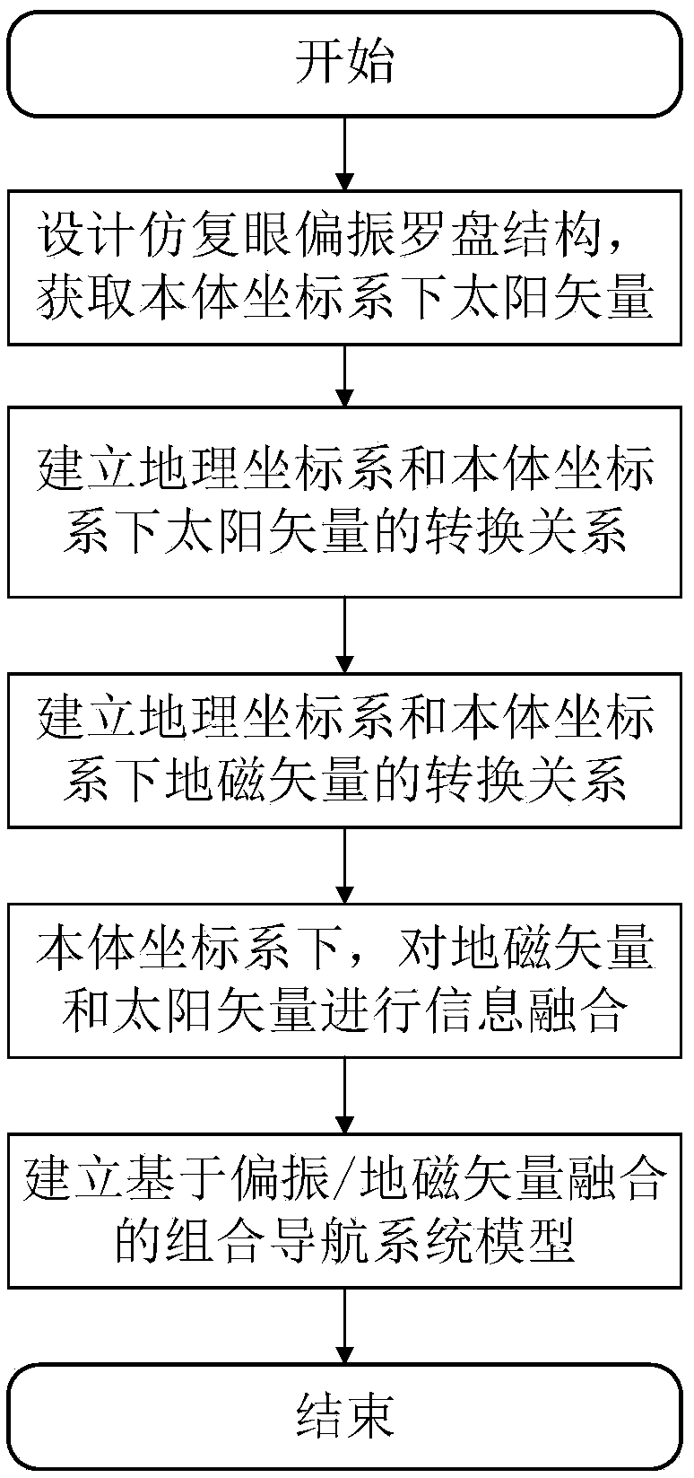
[0074] like figure 1 As shown, the specific implementation steps of a navigation method based on the tight combination of polarization-geomagnetic vector of the present invention are as follows:

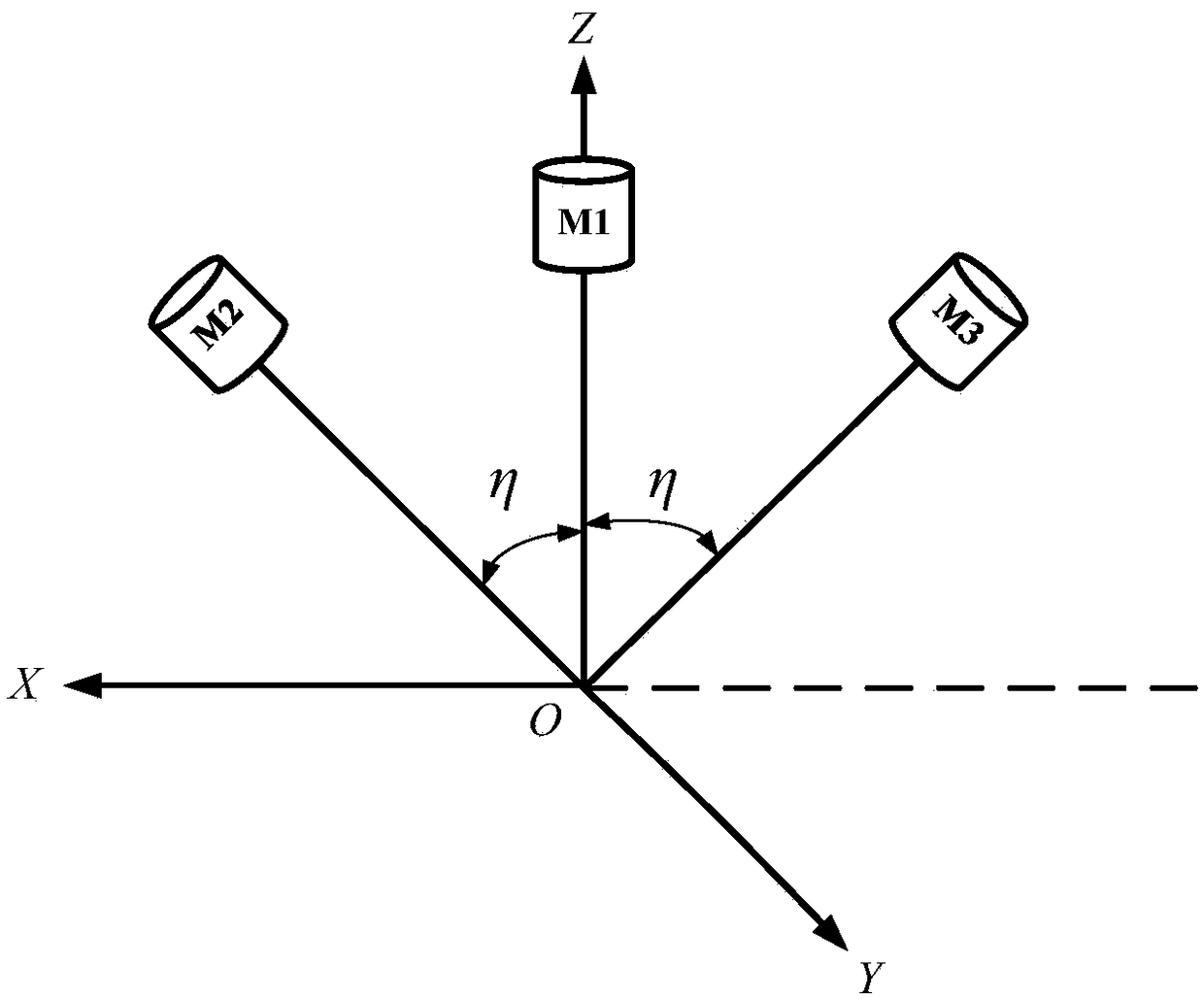
[0075] 1. The compound-eye-like polarization compass composed of polarization navigation sensors can obtain the sun vector in the coordinate system of the detection module in real time The schematic diagram of the compound eye polarized compass figure 2 As shown, the compound eye-like polarization compass consists of three polarization sensors, which are denoted as M 1 , M 2 , M 3 , where M 1 The observation direction is the zenith direction, M 2 and M 3 Symmetrically mounted on M 1 Measurement, the installation angle is η, with M 1 Establish a coordinate system Mxyz for the benchmark, the x-axis is the direction of the carrier body axis, the...


PUM


Abstract

The invention relates to a navigation method based on polarization-geomagnetic vector tight integration. The navigation method based on the polarization-geomagnetic vector tight integration comprisesthe following steps: firstly, intelligently extracting solar vector information under a carrier coordinate system by using an imitating compound eye polarization compass; secondly, acquiring the solarvector information under a geographic coordinate system in combination with solar astronomical ephemeris, and establishing an information conversion relation of a solar vector under a body coordinatesystem and the geographic coordinate system; extracting a geomagnetic vector under the body coordinate system and the geographic coordinate system, and establishing a conversion relation of the geomagnetic vector under the body coordinate system and the geographic coordinate system; then carrying out information integration on the geomagnetic vector and the solar vector under the body coordinatesystem; and finally, establishing a combined navigation system model based on polarization/geomagnetic vector integration. Compared with an existing method, the method has the advantages that deep integration of geomagnetic information and polarization information is realized, the system precision and stability can be improved, and the navigation method can be used for the fields of attitude determination and positioning and the like of carriers such as a ship, an unmanned aerial vehicle, a guided missile and an unmanned vehicle.

Description

technical field [0001] The invention relates to a navigation method based on a tight combination of polarization-geomagnetic vectors, which is used for the determination and positioning of autonomous attitudes in three-dimensional space of carriers such as unmanned aerial vehicles, ships and missiles. Background technique [0002] At present, the working environment of carriers such as unmanned aerial vehicles, ships, and missiles is becoming more and more complex. In order to make up for the shortage of single navigation, the combined navigation of multi-sensor fusion is the development direction of future navigation. Inertial / satellite integrated navigation system is the most widely used integrated navigation system at present, but satellite navigation is susceptible to natural environment and human interference, and cannot provide accurate and reliable navigation information in the environment of rejection, interference, and confrontation. Therefore, the application of sa...

Claims


Application Information

Patent Timeline
IPC IPC(8): G01C21/20G01C21/02G01C21/08
CPCG01C21/02G01C21/08G01C21/20
Inventor 郭雷杨健刘鑫王善澎
Owner BEIHANG UNIV
Why Eureka
Try Eureka