Method for recognizing vehicle violation behaviors with satellite positioning technology

A positioning technology and technology using satellites, applied in the field of vehicle violation behavior identification, can solve the problems of limited inspection coverage, inability to monitor real-time vehicle data all the time, no effective method to control the driver's deviation from the prescribed driving route, illegal speeding, etc.

Inactive Publication Date: 2013-08-07
RES INST OF HIGHWAY MINIST OF TRANSPORT
View PDF6 Cites 44 Cited by
  • Summary
  • Abstract
  • Description
  • Claims
  • Application Information

AI Technical Summary

Problems solved by technology

[0005] The present invention provides a method for identifying vehicle violations by using satellite positioning technology to solve the problems existing in the traditional technology that in the past only relying on manpower on-site inspection and correction, the terminal monitoring personnel of the established monitoring platform cannot always monitor the real-time data of the vehicle, and the inspection coverage is limited , there is no effective way to control technical problems such as deviation from the prescribed driving route and illegal speeding during the driving process of the driver, and effectively separate out multiple violations in the process of one query statistics, and can distinguish between normal speeding (such as overtaking) and illegal speeding and other behaviors, realizing the monitoring of "process overspeed"

Method used


Image

  • Method for recognizing vehicle violation behaviors with satellite positioning technology
  • Method for recognizing vehicle violation behaviors with satellite positioning technology
  • Method for recognizing vehicle violation behaviors with satellite positioning technology

Examples


Embodiment Construction

[0048] The present invention will be further described below in conjunction with the accompanying drawings and embodiments.

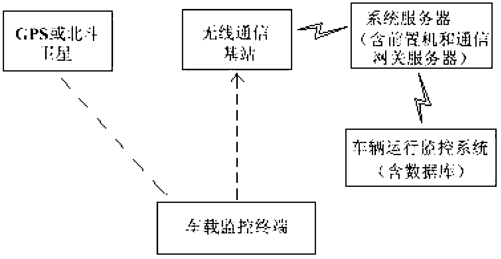
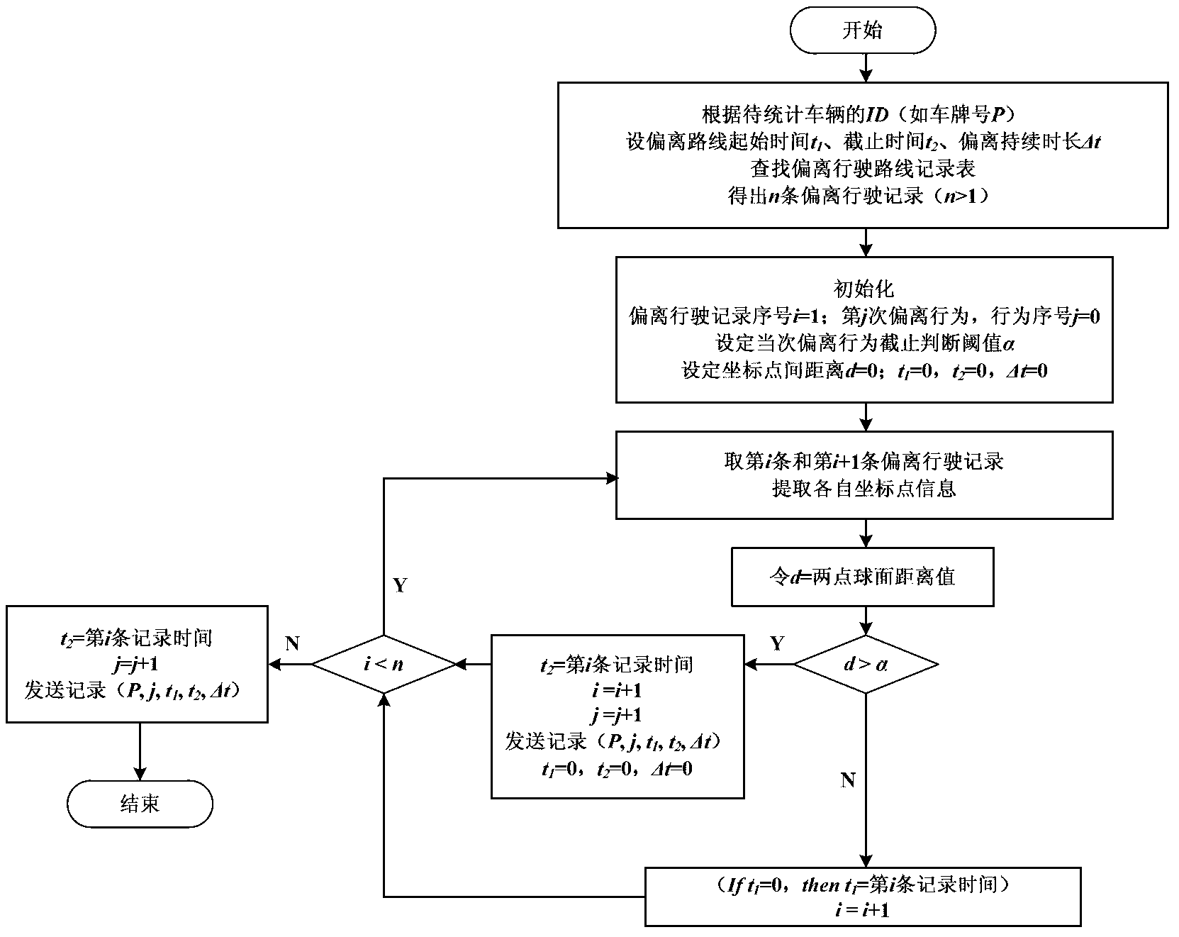
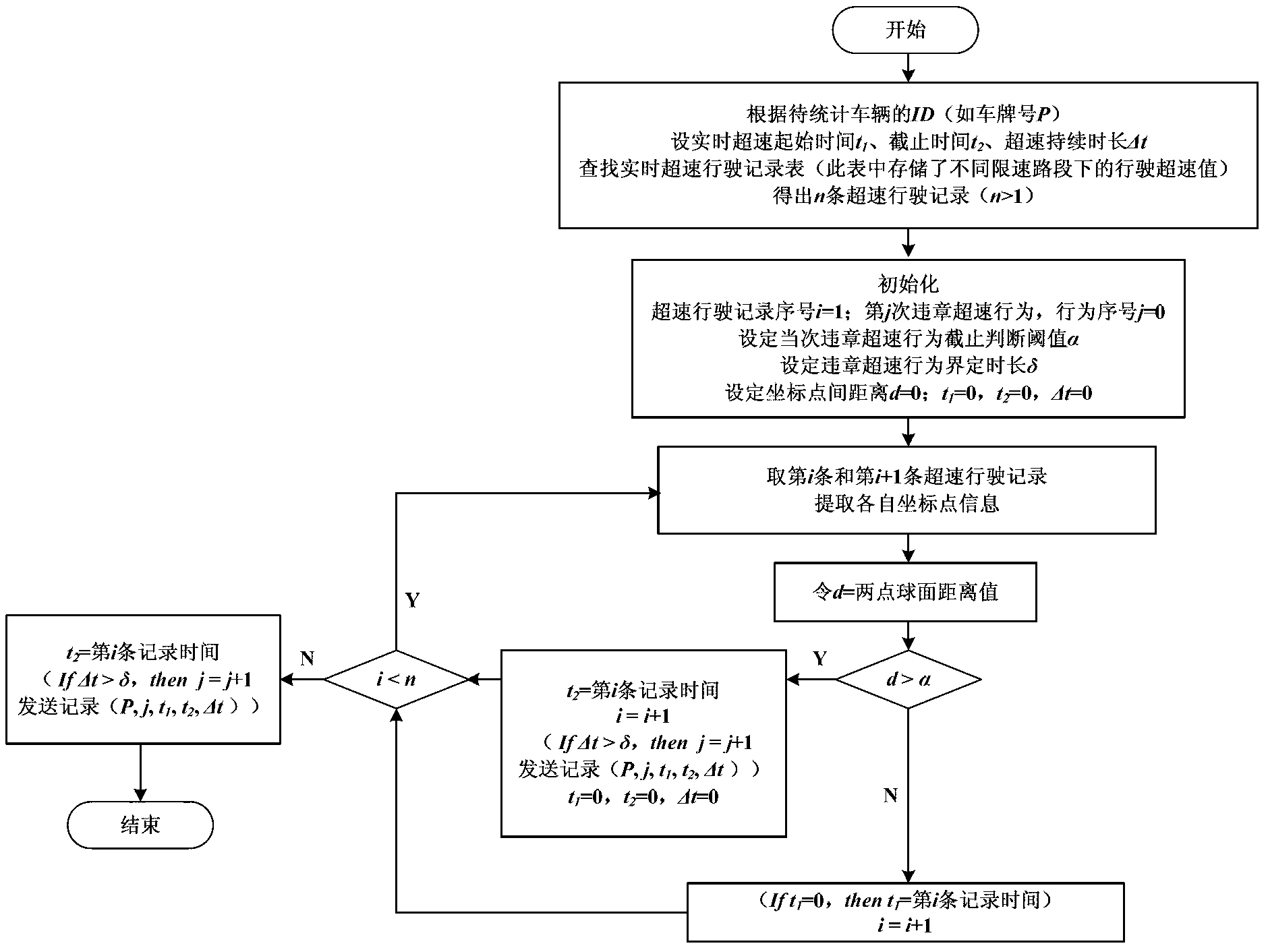
[0049] see figure 1 , figure 1 A schematic diagram of the principle of the inventive system of a preferred embodiment is shown. The present invention takes the long-distance bus management system as an example, but is not limited thereto, and can be extended to freight vehicle management systems and other related application fields. The long-distance bus management system includes a central system and a vehicle-mounted terminal. The vehicle-mounted terminal is located on a long-distance bus and is mainly responsible for: (1) receiving satellite positioning signals; (2) receiving various signals of the vehicle (such as braking, fuel consumption, door switches, cameras, etc.); (3) communicating with The communication between the central systems adopts wireless network communication or 3G wireless communication technology. The central system is a set o...


PUM


Abstract

The invention discloses a method for recognizing vehicle violation behaviors with a satellite positioning technology. The method comprises the following steps that spherical distance values and the like of a satellite positioning coordinate of a vehicle position and the geographical coordinate information of preset routes are compared with satellite positioning data uploaded from a vehicle-mounted terminal and the geographical coordinate information containing the preset routes, sectional speed limit values and other reference determination data which are pre-stored in a system database of a monitoring center so as to judge and calculate the behaviors and the times that a vehicle runs off regulated routes; the violating and over-speed behaviors and times are judged and calculated by comparing the real-time speed of the vehicle, the speed limit information of a current road section, spherical distance values between points, violation thresholds and the like; and whether the vehicle overspeeds or not is judged by comparing the actual arriving and preset arriving time at specific locations. Compared with the prior art, according to the algorithm, a plurality of violating behaviors in an inquiry and statistical process can be separated conveniently and accurately, so that normal over-speed (such as overtaking) and violating over-speed and other behaviors can be distinguished, and the monitoring to the process over-speed is realized.

Description

technical field [0001] The invention relates to a method and system for identifying vehicle violations by using satellite positioning technology. Background technique [0002] At present, domestic road passenger transport enterprises basically have a dynamic monitoring and management system based on satellite positioning technology to realize real-time monitoring and data storage of the vehicle driving process. The safety management department of the enterprise usually needs to check and count the illegal driving behavior of vehicles in order to effectively monitor and manage the situation of vehicles and drivers. The analysis shows that failure to follow the prescribed route, speeding and other situations are common violations in the process of vehicle operation, and are the main hidden dangers of traffic accidents caused by vehicles. How to use technical means to monitor in real time or use historical data to judge and statistically analyze the above violations will help ...

Claims


Application Information

Patent Timeline
Patent Type & Authority Applications(China)
IPC IPC(8): G08G1/01G08G1/123
Inventor 刘应吉蔡凤田赵侃周炜姚羽
Owner RES INST OF HIGHWAY MINIST OF TRANSPORT
Why Eureka
Try Eureka