Method for acquiring 3D (three-dimensional) point cloud by onboard 2D (two-dimensional) laser range finder

A technology of laser range finder and point cloud, which is applied in directions such as navigation through speed/acceleration measurement, which can solve the problem that the sensor is difficult to obtain 3D environmental information, and achieve the effect of reducing load burden, avoiding resource consumption, and using effectively

Active Publication Date: 2013-09-04
TSINGHUA UNIV
View PDF3 Cites 9 Cited by
  • Summary
  • Abstract
  • Description
  • Claims
  • Application Information

AI Technical Summary

Problems solved by technology

Different from ordinary ground robots, the aircraft has 6 degrees of freedom during flight, so it needs to obtain 3D information of its environment. However, most of the sensors in the existing technology are difficult to obtain effective 3D environmental information, and become the development of autonomous aircraft. bottleneck

Method used


Image

  • Method for acquiring 3D (three-dimensional) point cloud by onboard 2D (two-dimensional) laser range finder
  • Method for acquiring 3D (three-dimensional) point cloud by onboard 2D (two-dimensional) laser range finder
  • Method for acquiring 3D (three-dimensional) point cloud by onboard 2D (two-dimensional) laser range finder

Examples


Embodiment Construction

[0026] Embodiments of the present invention are described in detail below, and examples of the embodiments are shown in the drawings, wherein the same or similar reference numerals denote the same or similar elements or elements having the same or similar functions throughout. The embodiments described below by referring to the figures are exemplary only for explaining the present invention and should not be construed as limiting the present invention.

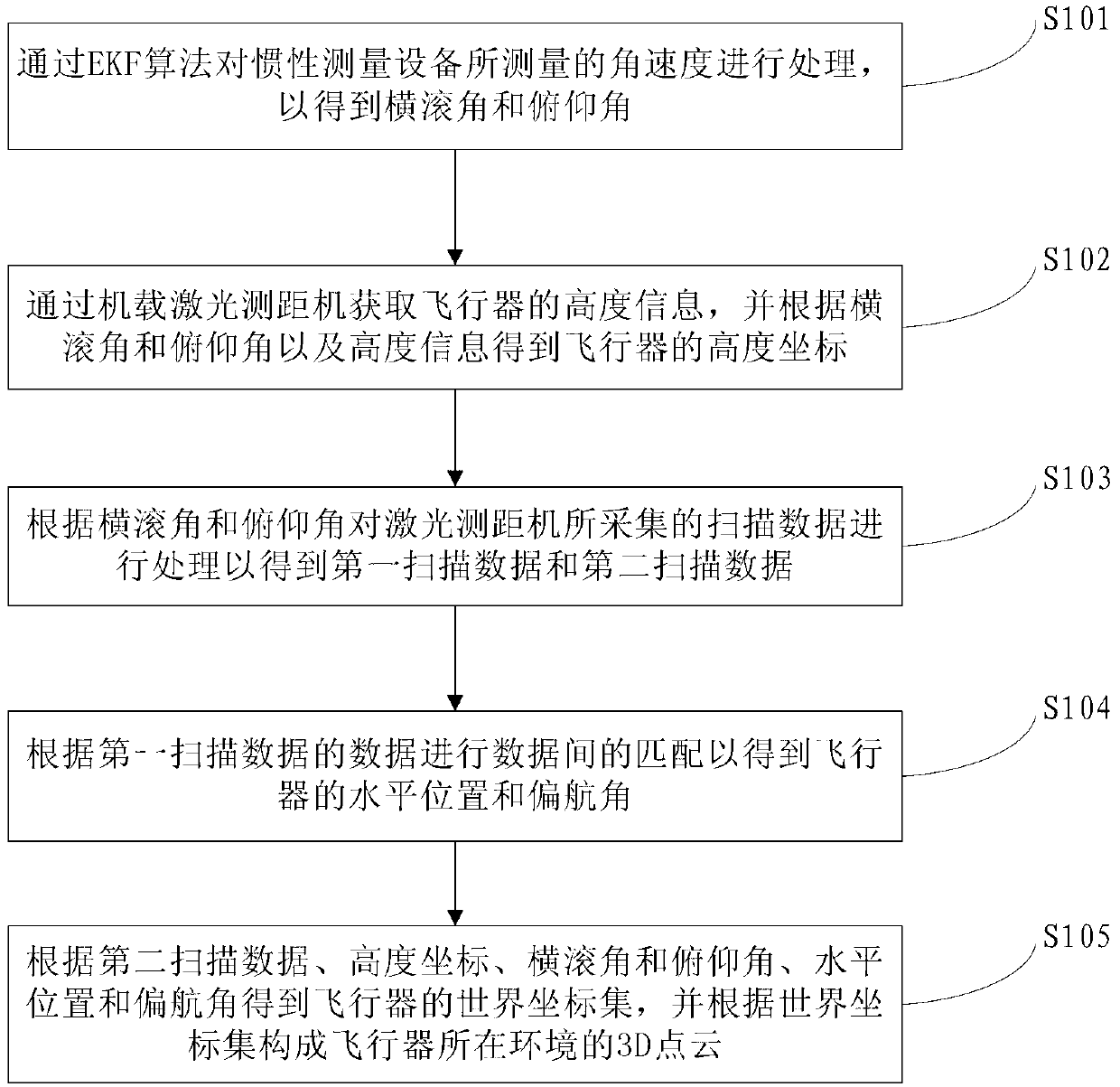
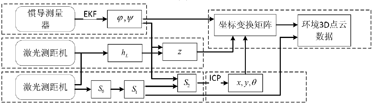
[0027] figure 1 It is a flowchart of a method for acquiring a 3D point cloud by an airborne 2D laser range finder according to an embodiment of the present invention. figure 2 It is a schematic diagram of data processing for a method for acquiring a 3D point cloud by an airborne 2D laser range finder according to an embodiment of the present invention. Such as figure 1 As shown, the method for obtaining a 3D point cloud by an airborne 2D laser rangefinder according to an embodiment of the present invention includes the foll...


PUM


Abstract

The invention discloses a method for acquiring a 3D (three-dimensional) point cloud by an onboard 2D (two-dimensional) laser range finder. The method for acquiring the 3D point cloud by the onboard 2D laser range finder comprises the following steps of: processing an angular velocity measured by an inertia measuring device through an EKF (extended Kalman filter) algorithm so as to obtain a roll angle and a pitch angle; acquiring the height information of an aircraft through the onboard laser range finder, and acquiring the height coordinate of the aircraft according to the roll angle and the pitch angle as well as the height information; processing scanning data collected by the laser range finder according to the roll angle and the pitch angle so as to obtain first scanning data and second scanning data; carrying out matching among data according to the first scanning data so as to obtain the horizontal position and the yaw angle of the aircraft; and acquiring the world coordinate set of the aircraft according to the second scanning data, the height coordinate, the roll angle and the pitch angle, the horizontal position and the yaw angle, and forming a 3D point cloud of an environment in which the aircraft is located according to the world coordinate set. According to the method in the embodiment of the invention, the autonomic performance of an unmanned aerial vehicle can be improved greatly.

Description

technical field [0001] The invention relates to the technical field of aircraft autonomous flight, in particular to a method for acquiring 3D point clouds by an airborne 2D laser range finder. Background technique [0002] With the development of microelectronics technology and robotics technology, it is possible for aircraft to have the ability to fly autonomously. At the same time, there are higher requirements for the autonomous performance of aircraft in the civil and military fields, especially in reconnaissance, rescue, monitoring, etc. demand is also increasing. Among them, the ability to perceive the environment is an important basis for the autonomous flight of the aircraft. If the information of the environment where the aircraft is located and the real-time estimation of its own position can be obtained, the autonomous performance of the drone will be greatly improved. Different from ordinary ground robots, the aircraft has 6 degrees of freedom during flight, so ...

Claims


Application Information

Patent Timeline
Patent Type & Authority Applications(China)
IPC IPC(8): G01C21/12G01C21/16
Inventor 戴琼海王玉旺李一鹏
Owner TSINGHUA UNIV
Why Eureka
Try Eureka