
Intermediate infrared two-channel remote sensing data surface temperature inversion method and device

A technology of surface temperature and remote sensing data, applied in the field of quantitative remote sensing, can solve problems such as difficult to accurately estimate, not detected, and changes in surface specific emissivity, and achieve the effect of avoiding inaccurate inversion accuracy and improving utilization

Active Publication Date: 2013-09-11
ACAD OF OPTO ELECTRONICS CHINESE ACAD OF SCI
View PDF5 Cites 33 Cited by
  • Summary
  • Abstract
  • Description
  • Claims
  • Application Information

AI Technical Summary

Problems solved by technology

At present, using spaceborne mid-infrared remote sensing technology to retrieve the surface temperature, the difficulties are mainly in three aspects: atmospheric correction, direct solar radiation estimation, and surface emissivity inversion, especially the estimation of solar direct radiation and surface emissivity inversion. The direct solar radiation reflected by the surface in the infrared spectrum is in the same order of magnitude as the emitted radiation from the surface itself. At the same time, the specific emissivity of the mid-infrared surface varies significantly under different types of ground objects, making it difficult to accurately estimate the specific emissivity of the surface.
At present, the inversion algorithms for surface temperature mainly focus on the single-window algorithm, window-splitting algorithm, multi-channel algorithm, and separation algorithm of temperature and specific emissivity in the thermal infrared spectrum (8-12 μm); Algorithms include a temperature-independent spectral index algorithm and a day-night algorithm. Both algorithms require daytime and nighttime supporting data from the mid-infrared and thermal infrared channels, and the surface temperature is retrieved on the premise that the surface emissivity remains constant day and night. ; At present, there is no relevant literature on the algorithm of surface temperature inversion purely using mid-infrared remote sensing data

Method used


Image

  • Intermediate infrared two-channel remote sensing data surface temperature inversion method and device
  • Intermediate infrared two-channel remote sensing data surface temperature inversion method and device
  • Intermediate infrared two-channel remote sensing data surface temperature inversion method and device

Examples


Embodiment Construction

[0023] The object of the present invention is to propose a method and device for inversion of surface temperature from infrared dual-channel remote sensing data in view of the deficiencies in the above-mentioned background technology. The present invention is explained below in conjunction with accompanying drawing.

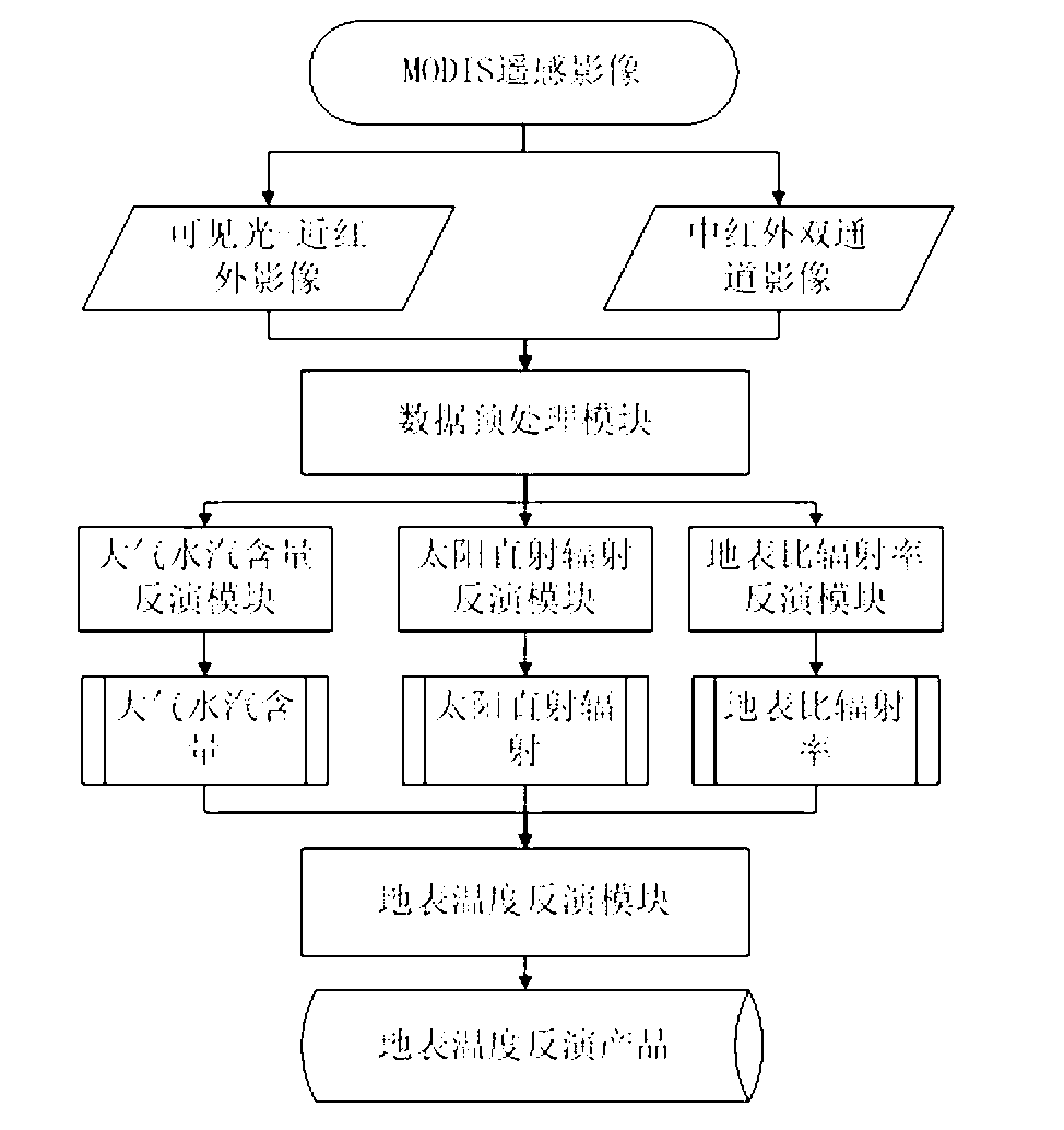
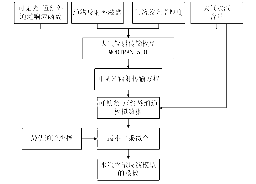
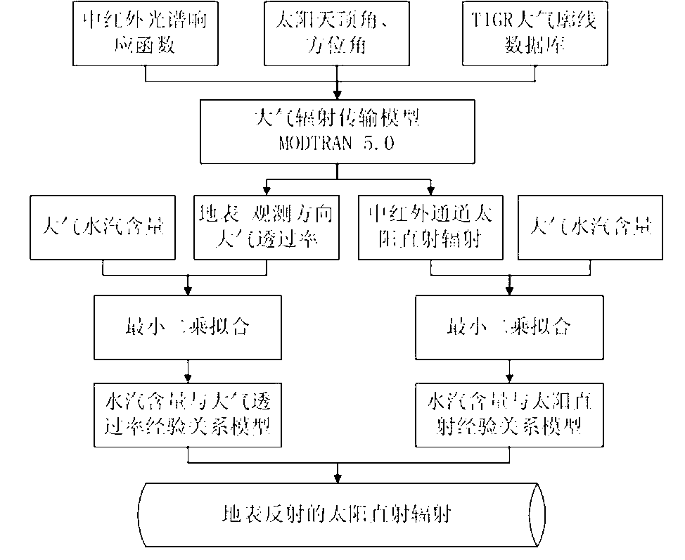
[0024] A kind of mid-infrared dual-channel remote sensing data surface temperature inversion device proposed by the present invention includes the following parts: a data preprocessing module connected to the input; Module, surface emissivity inversion module; surface temperature inversion module connected with atmospheric water vapor inversion module, surface reflected direct solar radiation module, and surface emissivity inversion module. The implementation structure and working principle of each module are as follows:

[0025] The data preprocessing module of the present embodiment is made up of projection conversion and radiance conversion two parts:

[002...


PUM


Abstract

The invention discloses an intermediate infrared two-channel remote sensing data surface temperature inversion method and device. The intermediate infrared two-channel remote sensing data surface temperature inversion method includes the steps that (A) MODIS remote sensing image data are processed in advance, (B) atmosphere moisture content inversion is carried out on the data to obtain the atmosphere moisture content, (C) by utilizing the product of the atmosphere moisture content in the step (B), surface direct solar radiation inversion and atmospheric transmissivity inversion in the observing direction of from surface to a sensor are carried out on the image data to obtain surface reflection direct solar radiation, and (D) by utilizing the product of MODIS surface transmissivity, the MODIS surface transmissivity is inverted to obtain surface emissivity. By means of the intermediate infrared two-channel remote sensing data surface temperature inversion method and device, the utilization rate of the data is effectively improved, and the problem of surface temperature inaccurate inversion caused by atmosphere downward radiation estimation errors is solved.

Description

technical field [0001] The invention relates to a mid-infrared dual-channel remote sensing data surface temperature inversion method and a device for realizing the method, belonging to the technical field of quantitative remote sensing. Background technique [0002] Infrared remote sensing earth observation technology, as an important observation method of space earth observation technology, can be widely used in military and civilian fields due to its advantages of being almost not limited by time, region, and environment, and being able to observe the earth all day long. Carry out ground object type detection and identification, mineral identification, geothermal, high temperature anomaly monitoring, military target reconnaissance, missile early warning, infrared guidance, military surveying and mapping, ocean surveillance, etc. Therefore, the infrared remote sensing earth observation technology has become one of the earth observation technologies that countries in the wor...

Claims


Application Information

Patent Timeline
IPC IPC(8): G01S7/48G01S17/95
CPCY02A90/10
Inventor 李传荣钱永刚王宁马灵玲唐伶俐胡坚赵恩宇
Owner ACAD OF OPTO ELECTRONICS CHINESE ACAD OF SCI
Learn More