Three-dimensional geographic information platform and topographic data processing method thereof

A technology of geographic information and terrain data, applied in the field of image processing, can solve the problems of data spatial information query, insufficient analysis support, high cost of 3D digital city construction, high software price, etc., and achieve the effect of optimizing browsing efficiency

Inactive Publication Date: 2013-09-18
GUANGDONG SOUTH DIGITAL TECH
View PDF2 Cites 19 Cited by
  • Summary
  • Abstract
  • Description
  • Claims
  • Application Information

AI Technical Summary

Problems solved by technology

[0004] The current 3D software for digital cities mainly focuses on the effect of 3D virtual reality. Compared with the spatial information of data, the query and analysis support is not enough; the support for massive 3D data is not enough. The current domestic digital city construction platform is not suitable for massive There are still many deficiencies in the support of the precise 3D model, and the price of the software is relatively high, resulting in a relatively high cost of 3D digital city construction
[0005] In addition, a typical digital city construction often involves rich data resources, including high-resolution remote sensing images, DEM, and rich-content thematic map data, but these information are often not effectively used after the system is set up. , if we can assist users to effectively organize, mana...

Method used


Image

  • Three-dimensional geographic information platform and topographic data processing method thereof
  • Three-dimensional geographic information platform and topographic data processing method thereof
  • Three-dimensional geographic information platform and topographic data processing method thereof

Examples


Embodiment

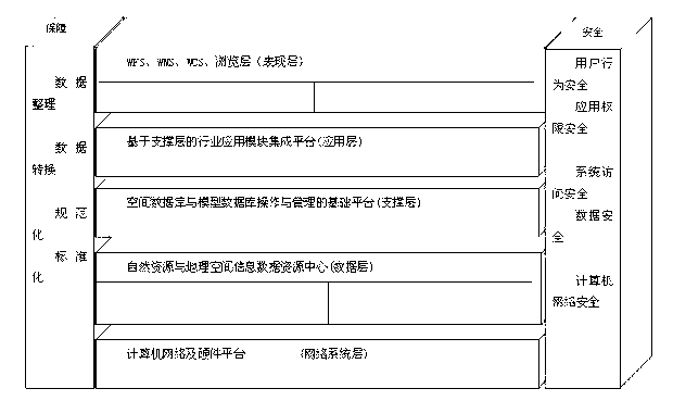
[0053] Such as figure 1As shown, the Eavr 3D digital city platform basically follows the "MVC" architecture, realizing the separation of data layer, business logic layer and presentation layer. Among the five physical layers of the Eavr 3D digital city platform, the network system layer corresponds to the network transmission and control capabilities of the database and system; the data layer corresponds to the "Model" in the three-tier system; the support layer corresponds to the application layer For the control (Control) in the three-tier system, the presentation layer corresponds to the "View" (View) in the three-tier structure. Among the five physical layers, the support layer is particularly special. It actually encapsulates the underlying support capabilities provided by the support modules of the Eavr 3D digital city platform. For many special application subsystems of the digital city project, the focus of work is on the application layer. In this way, cumbersome da...


PUM


Abstract

The invention discloses a three-dimensional geographic information platform and a topographic data processing method thereof. The platform comprises a network system layer, a data layer, a supporting layer, an application layer and a presentation layer; the application layer comprises a computer network and a hardware platform, and the safety of the computer network is guaranteed; the data layer is a natural resource and geographic space information data resource center; the supporting layer is a basic platform for operation and management of a space database and a model database; the application layer is a supporting layer-based industry application module integration platform; the presentation layer comprises WFS, WMS, WCS and a browse layer. A three-dimensional model used in the invention is formed by third-party professional modeling software, and also, the software can be used for forming simple three-dimensional model scenes, namely, a large area of simple three-dimensional scenes can be fast generated by adding a height field and a layer height field into attribute information according to polygon files in data line pictures.

Description

[0001] technical field [0002] The invention relates to the technical field of image processing, in particular to a three-dimensional geographic information platform and a terrain data processing method thereof. [0003] Background technique [0004] The current 3D software for digital cities mainly focuses on the effect of 3D virtual reality. Compared with the spatial information of data, the query and analysis support is not enough; the support for massive 3D data is not enough. The current domestic digital city construction platform is not suitable for massive There are still many deficiencies in the support of precise 3D models, and the price of the software is relatively high, resulting in a relatively high cost of 3D digital city construction. [0005] In addition, a typical digital city construction often involves rich data resources, including high-resolution remote sensing images, DEM, and rich-content thematic map data, but these information are often not effecti...

Claims


Application Information

Patent Timeline
IPC IPC(8): G06F17/30
Inventor 郑旭李少白贺正雄黎博豪董康
Owner GUANGDONG SOUTH DIGITAL TECH
Why Eureka
Try Eureka