Nonmagnetic inertial navigation unit calibration method based on image measuring technologies

A technology of image measurement and calibration method, which is applied in the field of non-magnetic inertial calibration system, can solve the problems of high site requirements, high cost, and the influence of motor magnetic field on calibration, etc., and achieve the effect of low cost and convenient use

Inactive Publication Date: 2013-12-04
CHINA INST OF SPORT SCI
View PDF6 Cites 11 Cited by
  • Summary
  • Abstract
  • Description
  • Claims
  • Application Information

AI Technical Summary

Problems solved by technology

But because the turntable is driven by a motor, the magnetic field generated by the motor will seriously affect the geomagnetic chip in the sensor, so this kind of turntable cannot calibrate the inertial sensor with a geomagnetic chip
The purely manual non-magnetic turntable is driven by manpower through gear transmission, which solves the problem that the magnetic field generated by the motor affects the calibration, but it is difficult to complete the synchronization of the sensor signal and the output of the turntable.
In addition, because the turntable is a special equipment, the installation of the equipment requires a special site, and the requirements for the site are very high, and the cost is very high

Method used


Image

  • Nonmagnetic inertial navigation unit calibration method based on image measuring technologies
  • Nonmagnetic inertial navigation unit calibration method based on image measuring technologies
  • Nonmagnetic inertial navigation unit calibration method based on image measuring technologies

Examples


Embodiment Construction

[0022] In order to have a further cognition and understanding of the features, purposes and functions of the present invention, the specific use of the present invention will be described below, and the detailed steps are as follows:

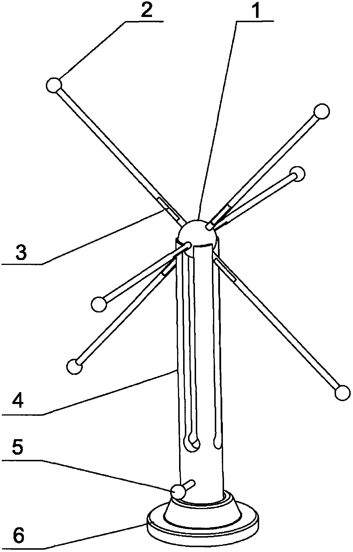
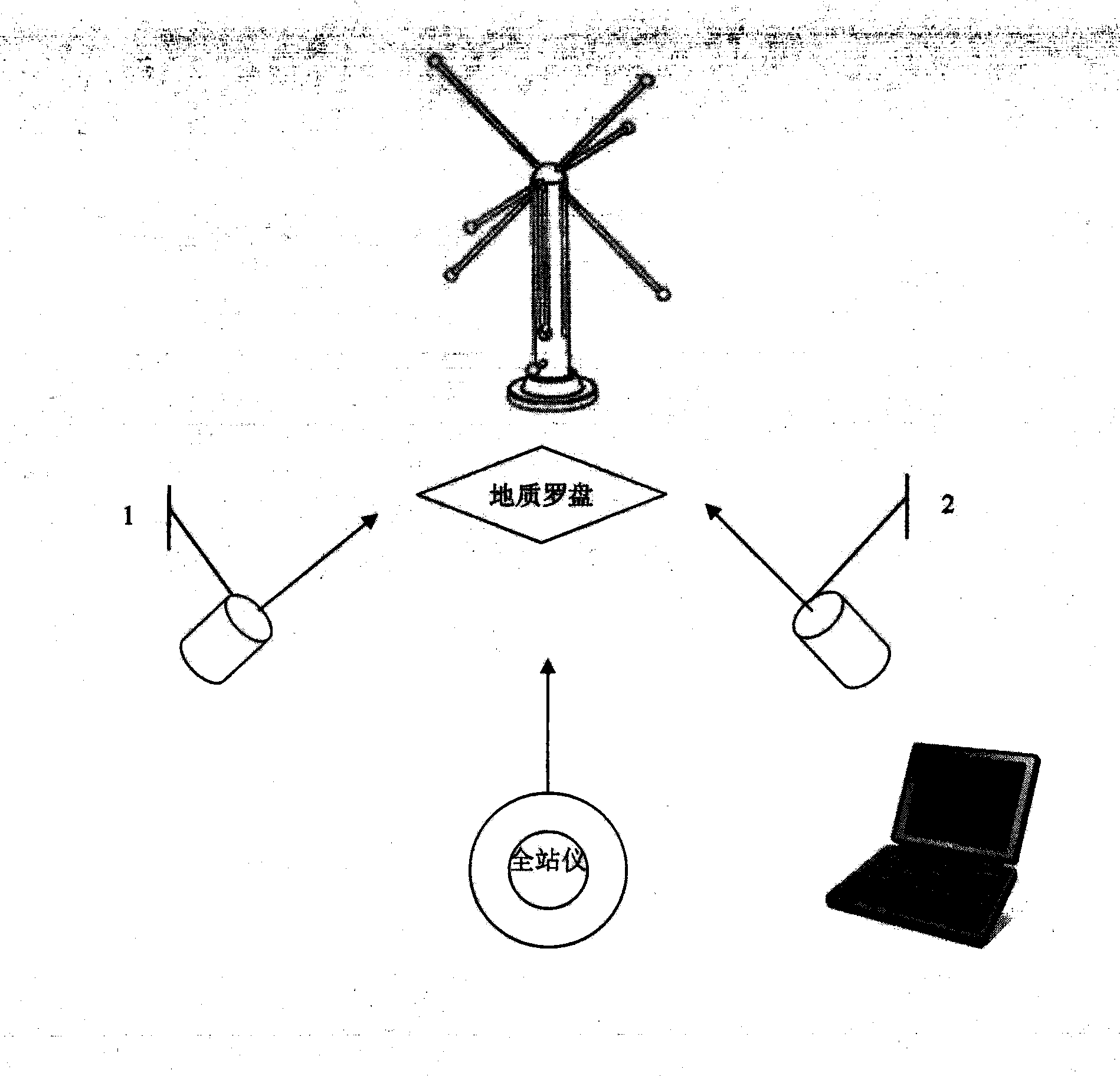
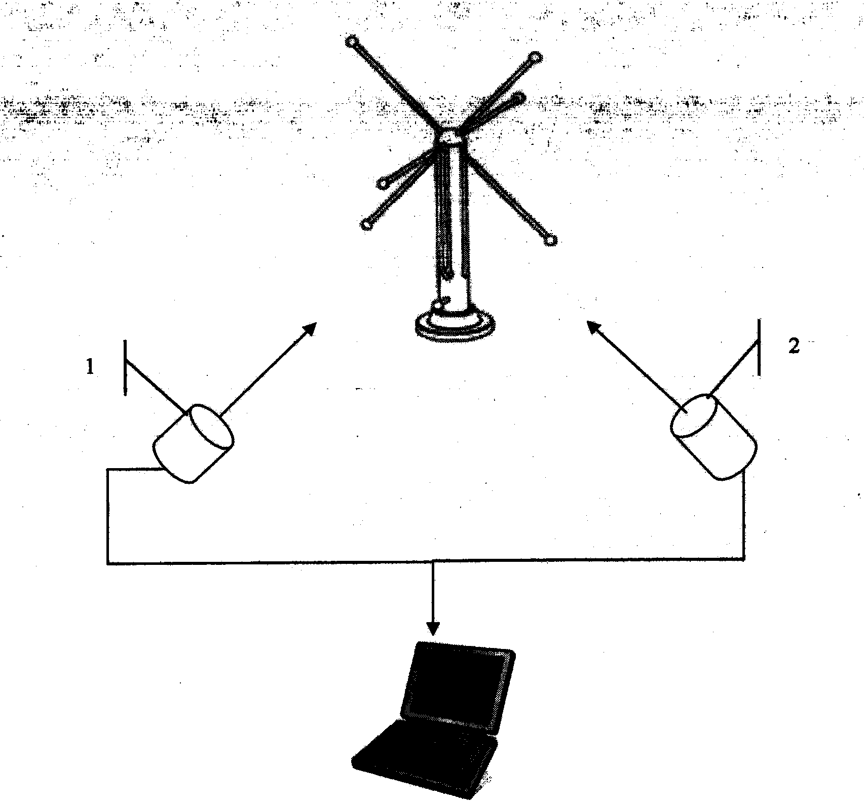
[0023] First, according to figure 2 Set up and debug the total station and camera to the working state, place the calibration frame to the predetermined position, ensure that the total station and camera system are not blocked after measurement, fix all parameters of the total station and camera until the end of the experiment, and It is required that there is no external strong magnetic field (display, power supply, electrical equipment, ferrous metal objects, etc.) in the experimental site close to the calibration frame.

[0024] 1 Determine the magnetic north direction of the local geomagnetic field

[0025] Place the geological compass horizontally within the scope of the calibration frame, mark two marking balls M1 and M2 on the center li...


PUM


Abstract

The invention relates to a nonmagnetic inertial navigation unit (IMU) calibration method based on image measuring technologies. A specialized nonmagnetic calibration frame, a geological compass and more than two vidicons are placed in a measuring environment. The space coordinate of the geological compass and the coordinate of the indication ball of the calibration frame of the image measuring analytic system are measured respectively by utilization of a total station, and a unified measuring coordinate system is constructed. An IMU to be measured is fixed on the frame. In the measuring frame, two white and reflective balls are arranged at each of three orthogonal directions of X, Y and Z and used for indicating axial directions. The measuring frame is revolved continuously around the X, Y and Z axes. The corresponding dynamic images are collected synchronously through the vidicons and the data output from the IMU is recorded at the same time. The indication ball space coordinate data is calculated through the mage measuring analytic system, and then the space attitude data of the frame is figured out and used as theory data. Through comparison of the theory data and the space attitude data output from the IMU, the error of the IMU is calculated, and finally the correction coefficient is obtained by utilization of the least square method.

Description

technical field [0001] The invention relates to a non-magnetic inertial calibration system which utilizes a total station, a geological compass and an image measurement and analysis system to calibrate an inertial sensor. Background technique [0002] Accurately measuring the attitude of a rigid body in three-dimensional space is crucial in the fields of aerospace, underwater transportation, industrial automation, virtual reality, and human kinematics analysis. An inertial measurement unit (IMU) based on accelerometers, magnetism, and gyroscopes is used to measure the motion and rotation trajectory of the target. The researchers can use the acceleration and angular velocity to calculate the roll angle (roll) and pitch angle (picth) relative to the gravity, and the IMU introduces the magnetometer to measure the heading angle (heading) of the target relative to the direction of magnetic north. [0003] For the calibration of the inertial sensor, the traditional method is to u...

Claims


Application Information

Patent Timeline
Patent Type & Authority Applications(China)
IPC IPC(8): G01C25/00
Inventor 李祥臣魏传民刘星张明辉侯祖贵李祥武
Owner CHINA INST OF SPORT SCI
Why Eureka
Try Eureka