Method for processing high-precision displacement deformation monitoring data based on Big Dipper

A monitoring data and high-precision technology, which is applied in the field of processing high-precision displacement and deformation monitoring data based on Beidou, can solve the problem that the Beidou satellite navigation system cannot achieve accurate positioning and orientation, and achieve the effects of high precision, simple algorithm and accurate results.

Active Publication Date: 2013-12-18
柳州天运寰通科技有限公司
View PDF2 Cites 11 Cited by
  • Summary
  • Abstract
  • Description
  • Claims
  • Application Information

AI Technical Summary

Problems solved by technology

However, there are still relatively few studies on how to solve the ambiguity parameters of the whole circle when applying the Beidou satellite navigation system in the current research in related fields. High precision positioning and orientation

Method used


Image

  • Method for processing high-precision displacement deformation monitoring data based on Big Dipper
  • Method for processing high-precision displacement deformation monitoring data based on Big Dipper
  • Method for processing high-precision displacement deformation monitoring data based on Big Dipper

Examples


Embodiment

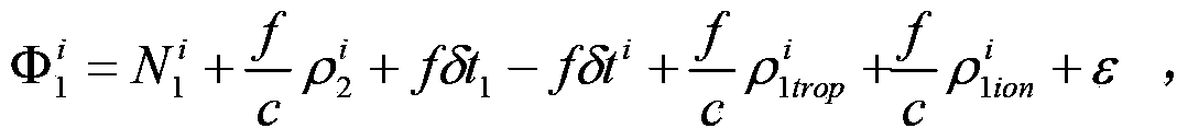
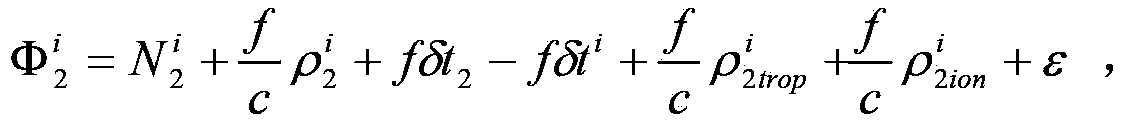
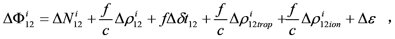
[0025] A method for processing high-precision displacement and deformation monitoring data based on Beidou, which is a method for processing the whole circle ambiguity parameter data in the process of monitoring geological displacement and deformation based on Beidou satellite navigation system and GPS navigation system and performing high-precision positioning ; which includes the following steps:

[0026] First, set up a GPS / Beidou combined receiver at the service station of the displacement and deformation monitoring center. transmission line connection;

[0027] Second, the GPS / Beidou combined receiver obtains the output pseudorange, carrier phase observation value and satellite ephemeris parameters of each observation epoch of the GPS navigation system and the Beidou satellite navigation system, and transmits the above data to the data processing center system;

[0028] Third, the data processing center system uses the carrier phase difference equation to calculate the i...


PUM


Abstract

The invention discloses a method for processing high-precision displacement deformation monitoring data based on the Big Dipper. The method is used for processing integer ambiguity parameter data obtained in the process of geological displacement deformation monitoring and high-precision positioning carried out based on a Beidou satellite navigation system and a GPS navigation system. The method includes the steps that (1) a GPS and Beidou combined receiver is arranged in a displacement deformation monitoring center service station; (2) the GPS and Beidou combined receiver obtains an output pseudo-range of each observation epoch, a carrier phase observation value and a satellite ephemeris parameter, and the preceding data are transmitted to a data processing center system; (3) the data processing center system calculates an integer ambiguity parameter by means of a carrier phase difference equation. According to the method, the high-precision integer ambiguity parameter can be obtained, and a good monitoring effect can be obtained when the Beidou satellite navigation system is applied to geological displacement deformation monitoring.

Description

technical field [0001] The invention belongs to the technical field of real-time monitoring of geological displacement and deformation based on a satellite navigation system, and in particular relates to a method for processing high-precision displacement and deformation monitoring data based on Beidou. Background technique [0002] Water conservancy projects, large buildings, mines, bridges, etc. are the basic structure of the national economy. As an important connection of national power, transportation network, and energy supply, they play a role that cannot be ignored in economic construction. Due to normal and abnormal loads, many water conservancy projects, bridges or mining areas, and geology have been deformed or damaged to varying degrees. Therefore, the health monitoring of water conservancy projects, bridges, and mining areas has become an important part of the normal operation and operation of water conservancy, bridges, and mines. The main tasks of the managemen...

Claims


Application Information

Patent Timeline
Patent Type & Authority Applications(China)
IPC IPC(8): G01S19/14
Inventor 刘治业
Owner 柳州天运寰通科技有限公司
Why Eureka
Try Eureka