Visual-content-based method for establishing multi-level semantic map

A semantic map and content technology, applied in the field of robot navigation, can solve the problems of expensive laser sensors, no division and construction, and limit the scope of robot activities, achieve fast insertion and query speed, reduce retrieval space and path search space, and solve self-limiting problems. Effect of Position Estimation Error Accumulation Problem

Active Publication Date: 2014-04-09
猫窝科技(天津)有限公司
View PDF5 Cites 29 Cited by
  • Summary
  • Abstract
  • Description
  • Claims
  • Application Information

AI Technical Summary

Problems solved by technology

[0004] To sum up, the existing technology has the following problems in the multi-layer description and visual navigation of the indoor environment: using the knowledge expression system to process semantic information requires the use of a network to connect to the knowledge base, which limits the scope of the robot's activities, querying and inserting knowledge The real-time performance is also affected; the existing visual navigation based on image retrieval maintains a large image retrieval library, and does not use the division of scenes in the indoor space to build a small retrieval library for different scenes to improve the accuracy of retrieval; in terms of self-positioning, through maintenance World coordinate system approach, self-positioning errors will accumulate over time; using laser sensors is generally more expensive

Method used


Image

  • Visual-content-based method for establishing multi-level semantic map
  • Visual-content-based method for establishing multi-level semantic map
  • Visual-content-based method for establishing multi-level semantic map

Examples


Embodiment Construction

[0049] The present invention will be further described below in conjunction with the drawings.

[0050] The flow chart of the method for creating a multi-layer semantic map of the present invention is as follows Figure 7 As shown, including the following steps:

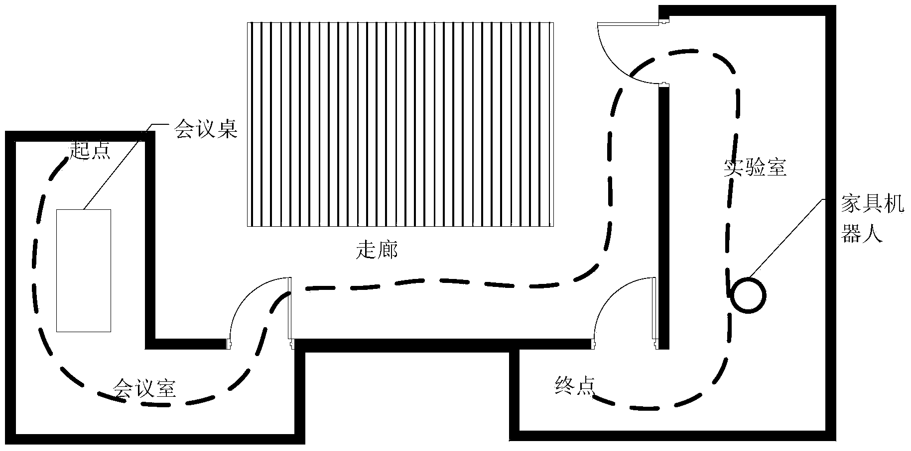
[0051] Step 1. Calibrate the camera and use an obstacle avoidance system to ensure that the robot will not collide. The robot roams in the indoor environment, saves the images taken during the roaming process, and annotates the images according to the scene and image content to which they belong to form an annotation file.

[0052] Step 2. Build a hierarchical vocabulary tree.

[0053] Extract all image feature vector sets, use the K-means algorithm to cluster the feature vector sets (root nodes) to form sub-feature vector sets (child nodes), iteratively perform K-means clustering on each sub-feature vector set until Satisfy the depth limit, save the cluster center of the child nodes stored in each node, and complete the c...


PUM


Abstract

The invention discloses a visual-content-based method for establishing a multi-level semantic map. The visual-content-based method comprises the following steps: gathering images shot by a robot wandering in an environment and labeling the scenes of spots for photography; constructing a hierarchical vocabulary tree; constructing a knowledge topological layer so as to grant knowledge to the knowledge topological layer; constructing a scene topological layer; constructing a spot topological layer. According to the visual-content-based method, a visual sensor is utilized for constructing the multi-level semantic map for a space, and digraph structure is used on the knowledge topological layer for storing and inquiring the knowledge, so that unnecessary operation can be eliminated in a knowledge expression system, and the inserting and inquiring speed is quick; the scene topological layer is utilized for carrying out abstract division on the environment so as to abstractly divide the whole environment into subdomains, so that the image searching space and the path searching space can be reduced; the spot topological layer is utilized for storing specific spot images, the self-positioning can be realized by adopting image searching technology, and the error accumulation problem of self-positioning estimation is solved without maintaining the global world coordinate system.

Description

Technical field [0001] The invention belongs to the field of robot navigation, and relates to a method for creating a multi-layer semantic map using a visual sensor. The multi-layer semantic map has three layers, including a topology map of specific location interconnection information, a scene interconnection topology map, and a knowledge topology map. Background technique [0002] Currently, mobile robots are widely used in industry, aerospace, military, and service fields. With the development of society, people have higher and higher requirements for the intelligence of robots, and service robots have become a hot spot for research and application. In a human navigation task, usually first think about the target location, such as "Where is the toy robot I am looking for", then "Where am I now", and then "How to get from where I am to where the toy robot is" local". The information such as "place" and "toy robot" is the semantic information in the environment. Humans with p...

Claims


Application Information

Patent Timeline
Patent Type & Authority Applications(China)
IPC IPC(8): G01C21/00G06F17/30
CPCG01C21/00G06F16/29
Inventor 杨金福赵伟伟解涛李明爱高晶钰张济昭
Owner 猫窝科技(天津)有限公司
Why Eureka
Try Eureka