ZigBee-based quadrocopter farmland positioning system

A four-axis aircraft and positioning system technology, applied in the field of farmland positioning system, can solve the problems of low equipment cost requirements, high price, and inability to adapt to farmland precision requirements, and achieve the effect of high-precision positioning

Active Publication Date: 2014-05-21
NORTHWEST A & F UNIV
View PDF3 Cites 33 Cited by
  • Summary
  • Abstract
  • Description
  • Claims
  • Application Information

AI Technical Summary

Problems solved by technology

Single-point positioning is based on the observation data of a receiver to determine the position of the receiver. It can only use pseudo-range observations for rough navigation and positioning. It is affected by system error sources and cannot adapt to row-by-row and plant-by-plant in farmland. The accuracy requirements of the job
Relative positioning is a method of determining the relative position between observation points

Method used


Image

  • ZigBee-based quadrocopter farmland positioning system
  • ZigBee-based quadrocopter farmland positioning system
  • ZigBee-based quadrocopter farmland positioning system

Examples


Embodiment Construction

[0034] The present invention will be described in further detail below in conjunction with the accompanying drawings.

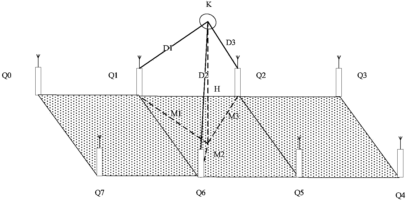
[0035] Such as figure 1 As shown, the ZigBee-based quadcopter farmland positioning system of the present invention is composed of beacon nodes (Q0-Q7) and the aircraft node K to be positioned. The beacon nodes (Q0-Q7) are a necessary condition of the system and also a distinctive feature of the system. This system mainly uses the existing ZigBee wireless sensor network for farmland information monitoring to establish the system of the present invention. Farmland information monitoring ZigBee network arranges the beacon nodes (Q0~Q7) in the gaps of the farmland in the form of ranks and columns through actual measurement.

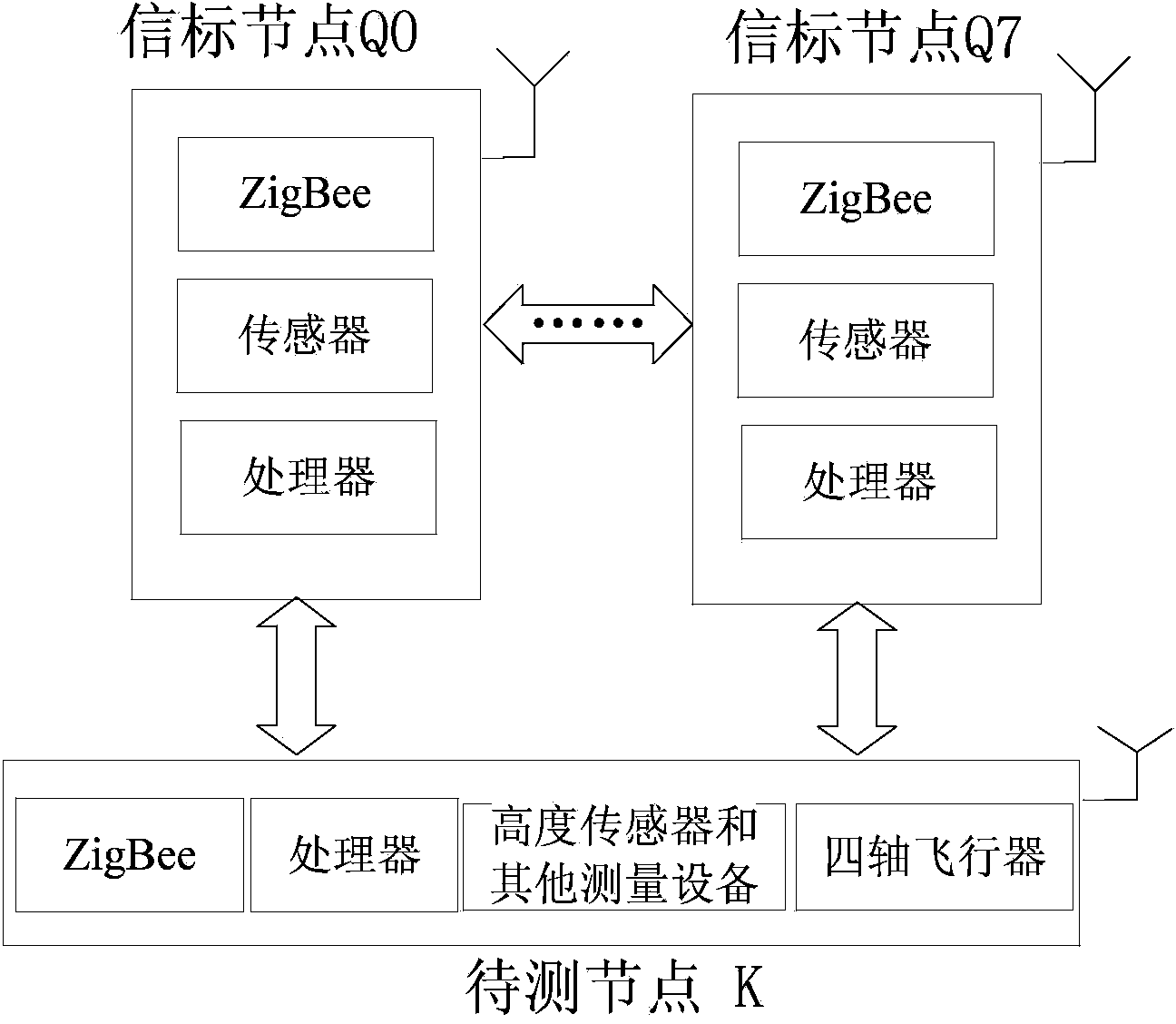
[0036]Simultaneously described aircraft node to be positioned comprises extended ZigBee module, when quadrocopter flies over farmland by remote control or automatic control, the height information obtained by itself of described aircraft n...


PUM


Abstract

The invention provides a ZigBee-based quadrocopter farmland positioning system which comprises a plurality of known positions, ZigBee beacon nodes at the same height, and to-be-positioned quadrocopter nodes composed of the quadrocopter and ZigBee nodes, and also a positioning method which comprises the steps of selecting four beacon nodes strongest in wireless signal intensity when the quadrocopter flies over the farmland, calculating the spatial distance between the node of the quadrocopter and each beacon node through the intensity of a received wireless signal, mapping the spatial distances into horizontal distances between the node of the quadrocopter and the beacon nodes within the horizontal plane, combining every three beacon nodes to form a triangular positioning subregion and forming 4 subregions in total, for each subregion, calculating the relative coordinates of the quadrocopter by a trilateral positioning method, next, calculating the center of mass of a quadrangle formed by the four pairs of relative coordinates by a center-of-mass method, and then taking the coordinates of the center of mass as the final position coordinates of the node of the quadrocopter. The ZigBee-based quadrocopter farmland positioning system is capable of realizing low-cost, high-precision and fast-positioned regional operation in the farmland.

Description

technical field [0001] The invention relates to the technical application of rapid positioning of small farmland areas, in particular to a farmland positioning system and method based on the combination of a wireless sensor network and a quadcopter. Background technique [0002] With the development of modern agriculture, small aerial vehicles such as drones have recently been used to monitor farmland diseases and insect pests, crop growth and farmland water conservancy conditions. On the basis of their perception of farmland information, they can rationally fertilize, sow, irrigate and spray pesticides to save costs. ,cut costs. However, to achieve these goals, it must rely on the precise positioning of drones in agricultural fields. [0003] Currently, UAV positioning mainly adopts Global Positioning System (GPS). This system consists of 24 satellites covering the whole world, which can ensure that at any time, any point on the earth can observe 4 satellites at the same ...

Claims


Application Information

Patent Timeline
IPC IPC(8): G01S5/10
CPCG01S5/14
Inventor 张海辉崔选科王东张家明杨小虎范叶满
Owner NORTHWEST A & F UNIV
Why Eureka
Try Eureka