Multi-sensor information fusion method based on GPS for agricultural machine navigation

An agricultural machinery and multi-sensor technology, applied in the field of GPS navigation and positioning of agricultural machinery, can solve problems such as Kalman filter divergence, achieve accurate estimation, enhance stability and applicability, and facilitate modular programming

Active Publication Date: 2014-06-25
SOUTH CHINA AGRI UNIV
View PDF2 Cites 29 Cited by
  • Summary
  • Abstract
  • Description
  • Claims
  • Application Information

AI Technical Summary

Problems solved by technology

But there is a problem: Tilt correction and Kalman filter are processed independently. Using the Kalman filte

Method used


Image

  • Multi-sensor information fusion method based on GPS for agricultural machine navigation
  • Multi-sensor information fusion method based on GPS for agricultural machine navigation
  • Multi-sensor information fusion method based on GPS for agricultural machine navigation

Examples


Embodiment 1

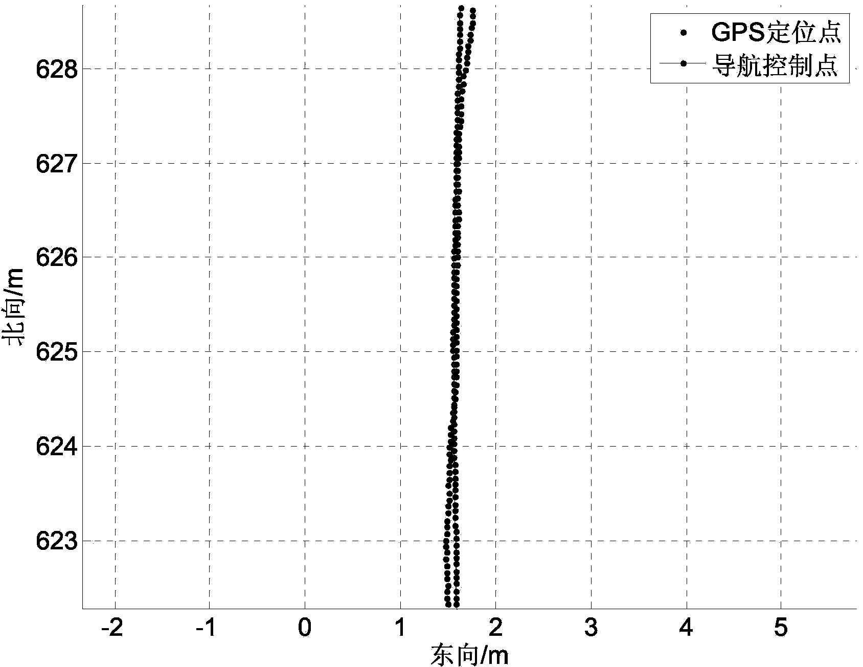
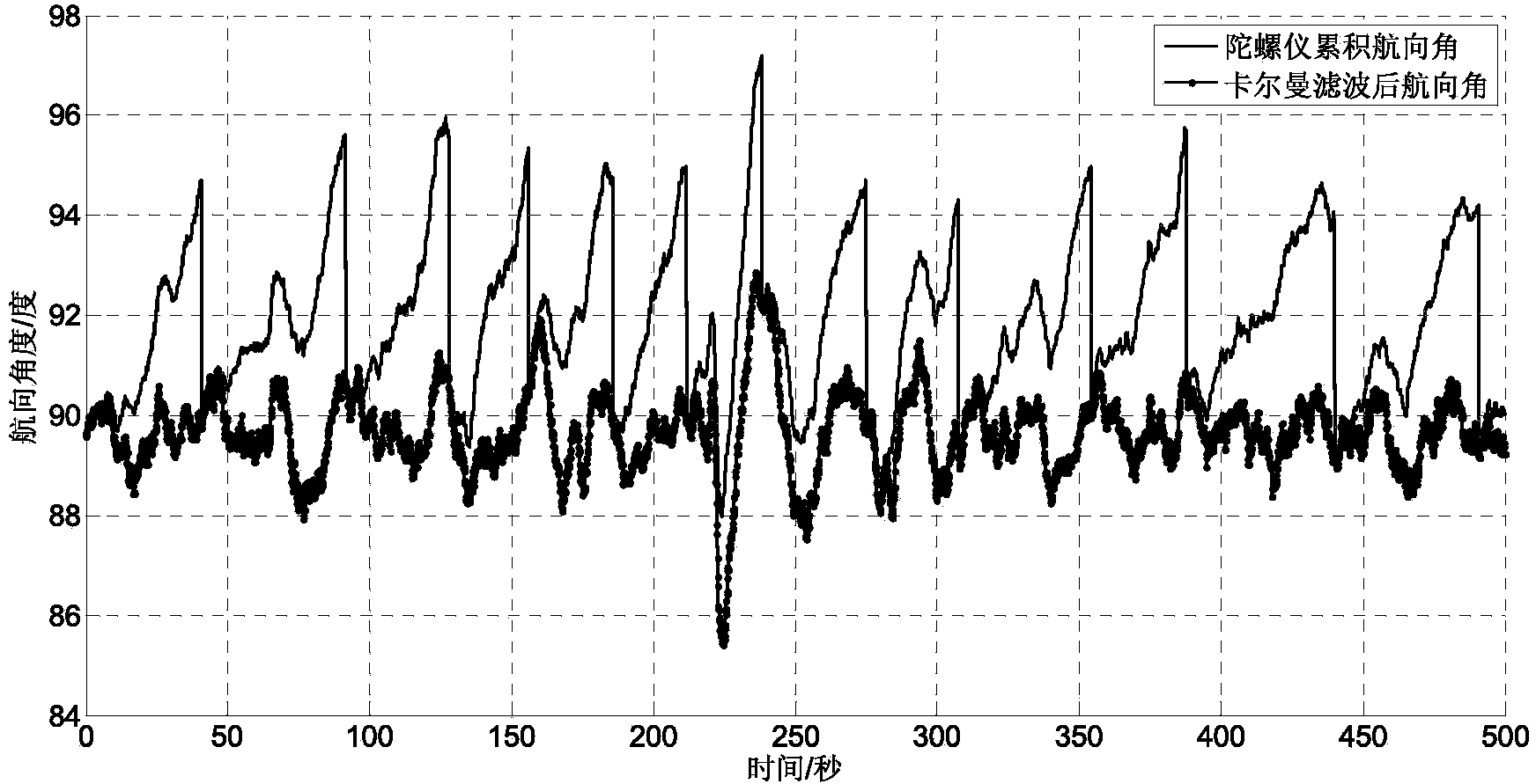
[0031] The agricultural machinery used in this example is Lovol M904-D wheeled tractor, and its navigation system mainly includes: navigation sensor combination, embedded development board and display terminal; wherein, the navigation sensor combination includes OEM RTK GPS board (Trimble BD970) And the micro-attitude and heading reference system AHRS (XSENS MTi), the GPS antenna is installed on the top of the tractor cab, on the central axis of the tractor, the three-axis pointing of the AHRS sensor coordinate system is the same as the three-axis pointing of the tractor body coordinate system, installed on the tractor Under the seat; the embedded development board and the navigation sensor combination are connected through the RS232 communication interface to realize the operation of software programs such as data collection, data preprocessing and information fusion; the data collection frequency of the navigation sensor combination is 10Hz, data collection, data The preproce...


PUM


Abstract

The invention discloses a multi-sensor information fusion method based on the GPS for agricultural machine navigation. The multi-sensor information fusion method includes the steps that measurement is conducted through a navigation sensor combination, so that the original latitude, the original longitude, the original height coordinate and the original advancing speed of an agricultural machine under the WGS-84 coordinate system are obtained, and the original roll angle, the original pitching angle, the original yaw velocity and the advancing-direction accelerated velocity the agricultural machine are obtained through measurement; the original latitude, the original longitude, the original height coordinate under the WGS-84 coordinate system are converted to be under the NEU earth navigation coordinate system to obtain an initial navigation positioning position value; the yaw velocity is converted into a course angle measured value after integration is conducted; the obtained original roll angle, the obtained original pitching angle, the obtained original yaw velocity, the obtained advancing-direction accelerated velocity the obtained initial navigation positioning position value and the obtained course angle measured value are fused through an improved kalman filter, so that accurate estimation of agricultural machine positioning and course angle information is obtained. According to the method, more continuous and more stable agricultural machine navigation data can be formed, and the estimation of the course angle is accurate.

Description

technical field [0001] The invention relates to a multi-sensor information fusion method, in particular to a multi-sensor information fusion method for GPS-based agricultural machinery navigation, and belongs to the technical field of GPS navigation and positioning of agricultural machinery. Background technique [0002] With the continuous development of GPS, Beidou and other satellite navigation and positioning technologies, electronic technology, machine vision technology, modern sensor testing technology and automatic control technology, and in line with the development trend of modern agricultural production, GPS-based agricultural machinery navigation technology and equipment are developing rapidly. , has become an important part of modern intelligent agricultural machinery and equipment, and provides good technical support for modern agricultural construction. The automatic navigation technology of agricultural machinery has been industrialized in developed countries ...

Claims


Application Information

Patent Timeline
IPC IPC(8): G01S19/47
CPCG01C21/165G01S19/47
Inventor 张智刚罗锡文胡炼单鹏辉张亚娇
Owner SOUTH CHINA AGRI UNIV
Why Eureka
Try Eureka