Supercharge Your Innovation With Domain-Expert AI Agents!

A Target Location Method for Aerial Cube Panoramic Imaging

A target positioning and panoramic imaging technology, applied in the field of target positioning, can solve the problem of target positioning without aerial cube panoramic images

Active Publication Date: 2016-03-30
BEIJING RES INST OF SPATIAL MECHANICAL & ELECTRICAL TECH
View PDF3 Cites 0 Cited by
  • Summary
  • Abstract
  • Description
  • Claims
  • Application Information

AI Technical Summary

Problems solved by technology

At present, there is no related method for target positioning of aerial cube panoramic images

Method used


Image

  • A Target Location Method for Aerial Cube Panoramic Imaging
  • A Target Location Method for Aerial Cube Panoramic Imaging
  • A Target Location Method for Aerial Cube Panoramic Imaging

Examples


Embodiment Construction

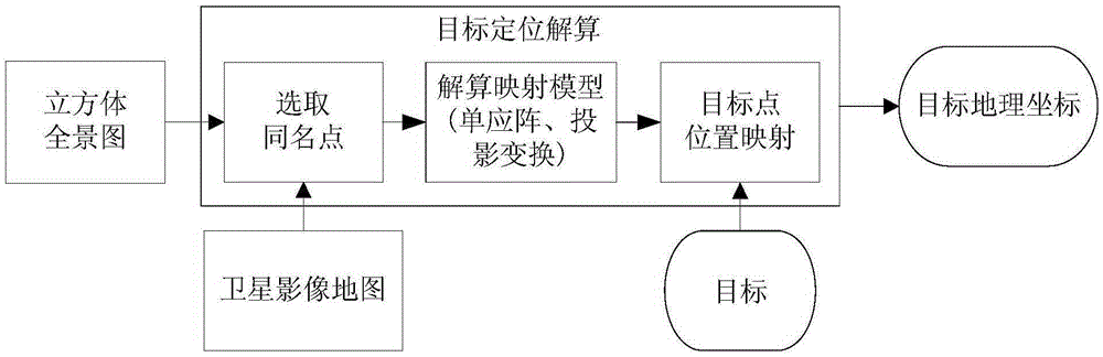
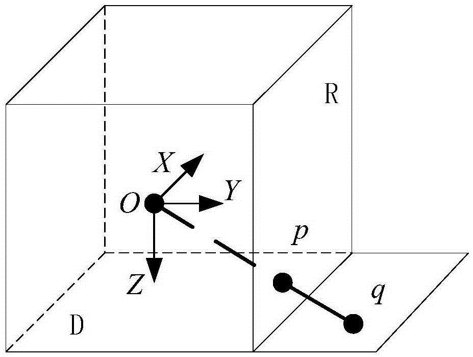
[0020] The cubic panorama composed of six square imaging surfaces has become a widely used panorama imaging mode because of its relatively convenient data compression and storage. It is also the panorama format first promoted by Apple’s panoramic video software QuickTimeVR. To find the mapping model of the cube panorama and satellite image map, the mutual mapping relationship between different cube faces must be properly resolved, so that the same name points on different faces can be used to obtain a more accurate mapping model.

[0021] The invention provides a method for panoramic imaging of cubes in the sky, using a satellite image map as a reference library to realize precise target positioning. figure 1 It is a work flow diagram of the general idea of ​​the whole method. The cube panorama is captured in the specified aerial photography area, and the satellite image data of the aerial photography area is retrieved, and several points with the same name are obtained throug...


PUM


Abstract

The invention discloses a target positioning method for panoramic overhead cube imaging. According to the method, a panoramic image of an overhead cube is used as a research object, and a digital satellite image map is selected as a positioning reference, so that a geographical position of any target point in the panoramic image of the overhead cube is calculated according to homonymy points of an aerial image and a satellite image. The method fully considers the characteristic of the panoramic overhead cube imaging, so that a mapping model suitable for the panoramic image of the overhead cube is deducted; meanwhile, richer scene information is also supplied by the panoramic imaging, more homonymy points can be found, and the positioning model of the mapping model is further improved. By the method, a target can be quickly positioned under map-level precision theoretically; the method is also suitable for a low-cost unmanned plane platform without a high-precision navigation sensor or a stable platform condition.

Description

technical field [0001] The invention belongs to the technical field of target positioning, and relates to a target positioning method for aerial cube panorama imaging. Background technique [0002] Panoramic imaging, because it can provide 360-degree scene information and give people an immersive feeling, has been increasingly used in virtual reality fields such as street view display and indoor scene roaming. With the maturity of the UAV market, aerial panoramic imaging has developed rapidly in recent years. Whether it is post-disaster on-site investigation for the purpose of rescue and reconstruction, or road condition monitoring for the purpose of traffic control, aerial panoramic imaging is more advanced than traditional aerial photography. Narrow field of view shooting, imaging coverage is wider, and can provide full-view scene information for overall situation assessment. However, the application of aerial panoramas is currently mostly at the qualitative analysis leve...

Claims


Application Information

Patent Timeline
Patent Type & Authority Patents(China)
IPC IPC(8): G01C11/04
CPCG01C11/04
Inventor 张春晓文高进宋立国姚毅刚林招荣吴春楠王洪民尚志鸣张倩
Owner BEIJING RES INST OF SPATIAL MECHANICAL & ELECTRICAL TECH
Features
  • R&D
  • Intellectual Property
  • Life Sciences
  • Materials
  • Tech Scout
  • Unparalleled Data Quality
  • Higher Quality Content
  • 60% Fewer Hallucinations
Learn More