Remote-sensing image atmosphere proximity effect correction method based on atmosphere separation MTF

A remote sensing image and proximity effect technology, applied in the field of aerospace remote sensing, can solve the problems of blind restoration of impact elimination methods, not considering quantitative applications, and inaccurate estimation of atmospheric point expansion functions.

Active Publication Date: 2014-07-30
BEIJING RES INST OF SPATIAL MECHANICAL & ELECTRICAL TECH
View PDF4 Cites 11 Cited by
  • Summary
  • Abstract
  • Description
  • Claims
  • Application Information

AI Technical Summary

Problems solved by technology

[0005] The technical problem solved by the present invention is: to overcome the deficiencies of the prior art, and to provide a remote sensing image atmospheric proximity effect correction method based on the separated atmospheric MTF, which can solve the problems of blind restoration, unaccounted for Quantitative application and inaccurate estimation of atmospheric point spread function

Method used


Image

  • Remote-sensing image atmosphere proximity effect correction method based on atmosphere separation MTF
  • Remote-sensing image atmosphere proximity effect correction method based on atmosphere separation MTF
  • Remote-sensing image atmosphere proximity effect correction method based on atmosphere separation MTF

Examples


Embodiment Construction

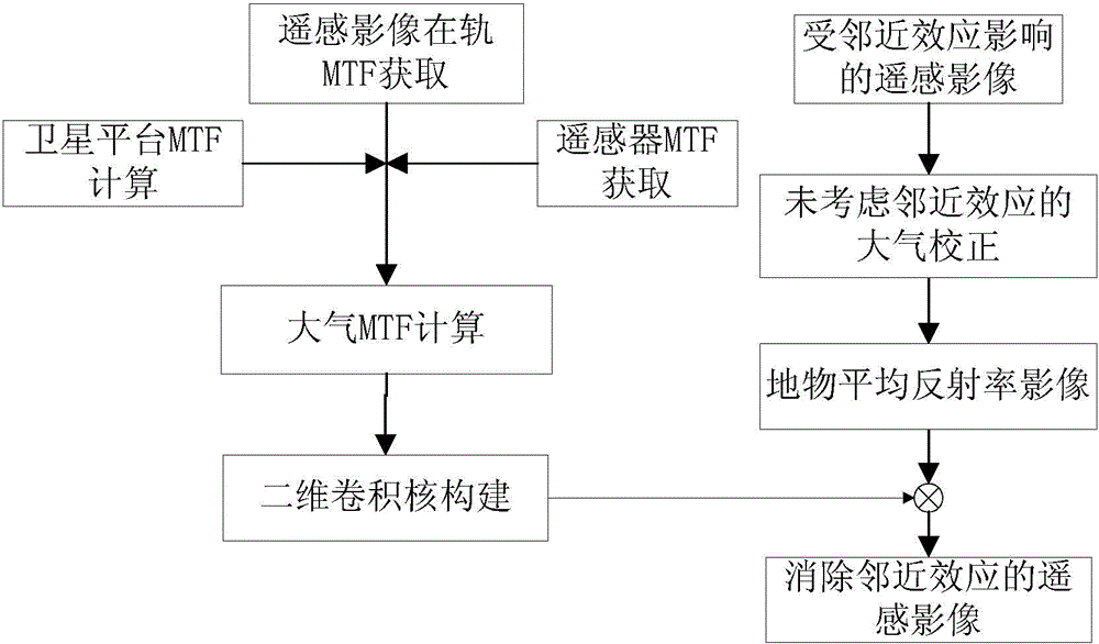
[0030] Such as figure 1 Shown, be the flow chart diagram of the inventive method, main steps are as follows:

[0031] (1) Obtain the on-orbit MTF of the remote sensing image.

[0032] The on-orbit MTF of remote sensing images can be obtained by using the more commonly used edge method or pulse method, expressed as MTF on-orbit .

[0033] For the principle and specific steps of the knife-edge method, please refer to the article "Research on On-orbit MTF Measurement of Aerospace Optical Remote Sensors Based on the Knife-edge Method" in "Aerospace Return and Remote Sensing", Volume 30, No. 2, 2009.

[0034] For the principle and specific steps of the pulse method, please refer to the report "Quickbird Satellite in-orbit Modulation Transfer Function (MTF) Measurement Using Edge, Pulse and Impulse Methods for Summer 2003" by Stennis Space Center in August 2008.

[0035] (2) Obtain the MTF of the remote sensor.

[0036] In the laboratory, the MTF of the remote sensor can be obta...


PUM


Abstract

The invention provides a remote-sensing image atmosphere proximity effect correction method based on atmosphere separation MTF. The method includes the steps that firstly, remote sensor on-orbit imaging MTF, static remote sensor MTF and satellite platform MTF are acquired respectively, wherein the remote sensor on-orbit MTF is acquired from a remote sensor image through a knife-edge method, the static remote sensor MTF is acquired through testing in a remote sensor laboratory, the satellite platform MTF is acquired through satellite platform on-orbit test parameters in a simulation mode, and the atmosphere MTF is worked out though the remote sensor on-orbit imaging MTF, the static remote sensor MTF and the satellite platform MTF according to on-orbit remote sensor image degradation mechanism; secondly, a two-dimension smoothing convolution kernel of an atmosphere proximity effect is built by using the atmosphere MTF and according to the finite long-digital filter theory; finally, for an optical remote sensing image after absolute radiation correction, atmosphere correction is conducted by using an MODTRAN atmosphere radiation transfer model, convolution is conducted by using the built two-dimension smoothing convolution kernel, and the remote image without the atmosphere proximity effect is finally obtained.

Description

technical field [0001] The invention belongs to the technical field of aerospace remote sensing, and relates to an atmospheric scattering correction method for remote sensing images, which can be used for atmospheric correction and quantitative remote sensing inversion of optical remote sensing images. Background technique [0002] With the development of high-resolution optical remote sensing satellites and the competition of foreign high-resolution remote sensing images, users have higher and higher requirements for the quality of high-resolution optical remote sensing images. At present, high-resolution images often have low on-orbit MTF and blurred images, and the influence of the atmosphere cannot be ignored. [0003] At present, there are many image restoration methods to eliminate the influence of the atmosphere, but most of them are based on image filtering and lack effective and in-depth integration with remote sensing quantitative applications. On the one hand, ima...

Claims


Application Information

Patent Timeline
Patent Type & Authority Applications(China)
IPC IPC(8): G01S7/497
CPCG01S7/48G01S7/497
Inventor 鲍云飞何红艳周楠齐文雯高慧婷刘薇王殿中刘爽岳春宇江澄
Owner BEIJING RES INST OF SPATIAL MECHANICAL & ELECTRICAL TECH
Why Eureka
Try Eureka