Integrally-imaging image mapping method based on coordinate transformation

A mapping method and coordinate transformation technology, which can be used in measurement devices, instruments, surveying and mapping, and navigation, etc., and can solve problems such as increased computational time overhead, degradation of image details, and complex methods.

Inactive Publication Date: 2014-09-17
HUBEI UNIV OF AUTOMOTIVE TECH
View PDF5 Cites 6 Cited by
  • Summary
  • Abstract
  • Description
  • Claims
  • Application Information

AI Technical Summary

Problems solved by technology

[0008] In order to solve the problems that the existing complete imaging mapping method is complicated, the calculation time overhead of the computer CPU is increased, and the details of the image are obviously degraded, the present invention proposes a method that can generate output images pixel by pixel, without the problem of waste of calculation and A complete imaging mapping method based on coordinate transformation that facilitates the application of high-precision interpolation algorithms

Method used


Image

  • Integrally-imaging image mapping method based on coordinate transformation

Examples


Embodiment Construction

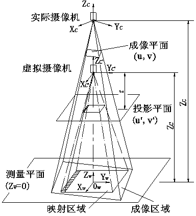
[0036] Such as figure 1As shown, the present invention is based on the complete imaging mapping method of coordinate transformation, which includes:

[0037] 1. Correction of camera pose

[0038] 1) The camera shoots multiple images of the target plane in different poses, and applies the plane calibration method to the corresponding point relationship between each feature point on the target and the corresponding image point on the image, and performs an optimization search to accurately obtain the internal parameters of the camera.

[0039] 2) Place the target flat on the measurement plane, and set the world coordinate system {W with the target plane as the XY plane 1}.

[0040] 3) Using the camera to image the target plane again, the world coordinate system {W 1} The homogeneous transformation matrix described by the pose relative to the camera coordinate system {C} . for the matrix Perform Euler angle transformation according to formula (2) to obtain the RPY angle ...


PUM


Abstract

The invention relates to an integrally-imaging image mapping method based on coordinate transformation. The method comprises the steps of alignment of the pose of a video camera and establishment of an image distortion-free zooming plane backward mapping mathematic model; in the step of alignment of the pose of the video camera, the video camera is used for conducting visual pose detection on a 2D calibration template on a detection platform to obtain the inclination angle between the optical axis of the video camera and the detection platform, the pitch angle and the deflection angle of a double-degree-of-freedom accuracy adjusting device are adjusted according to the inclination angle, and finally it is guaranteed that the optical axis of the video camera is perpendicular to the detection platform; the image distortion-free zooming plane backward mapping mathematic model is established on the basis of an image collected when the optical axis of the video camera is perpendicular to the detection platform. By means of the mapping method, a coordinate position mapping relation between a projection plane and an imaging plane, namely a backward mapping method is established. According to the mapping method, the concept is simple and reasonable, output images can be generated pixel by pixel, calculation waste can not be caused, and application of a high-accuracy interpolation algorithm is facilitated.

Description

technical field [0001] The invention relates to a complete imaging mapping method, in particular to a complete imaging mapping method based on coordinate transformation. Background technique [0002] At present, visual inspection technology is widely used in various fields of industry, and the measurement methods and methods based on machine vision have also been developed rapidly. However, the research on visual measurement of geometric dimensions mainly focuses on microstructures or small-sized parts. The main reason is that the pixel-level relative measurement accuracy of CCD devices is only 10 -3 The order of magnitude, while the imaging area of ​​the vision system once imaged and the detection resolution are inversely proportional to each other. When performing image measurement on tiny objects, due to the small field of view, the resolution of the image measurement can be improved accordingly to improve the measurement accuracy; for the comprehensive detection of the ...

Claims


Application Information

Patent Timeline
Patent Type & Authority Applications(China)
IPC IPC(8): G01B11/00G01C11/00
Inventor 刘凌云罗敏吴岳敏
Owner HUBEI UNIV OF AUTOMOTIVE TECH
Why Eureka
Try Eureka