Agricultural remote sensing system

A remote sensing and agricultural technology, applied in the field of remote sensing, can solve the problems of high cost, lack of spatial and temporal representation, and difficult to obtain accurate information in farmland communities, and achieve the effect of reducing consumption and avoiding constant working conditions.

Inactive Publication Date: 2014-09-17
BEIJING RES CENT FOR INFORMATION TECH & AGRI
View PDF9 Cites 22 Cited by
  • Summary
  • Abstract
  • Description
  • Claims
  • Application Information

AI Technical Summary

Problems solved by technology

Traditional field surveys are limited by the number of sample points and workload, so it is difficult to cover continuously in time and space, and there is insufficient representation in time and space of "replacing areas with points". Satellite remote sensing observations can achieve continuous coverage in space, but usually due to the relatively low spatial resolution of pixels. Low, it is difficult to obtain accurate information in farmland communities, and due to the long revisit cycle of satellite data, data cannot be obtained in time; manned aerial remote sensing has high data acquisition costs, and under the strict conditions of China's aviation control, it is difficult to be widely used in agricultural production application

Method used


Image

  • Agricultural remote sensing system
  • Agricultural remote sensing system
  • Agricultural remote sensing system

Examples


Embodiment Construction

[0021] The specific implementation manners of the present invention will be further described below in conjunction with the drawings and examples. The following examples are only used to illustrate the technical solution of the present invention more clearly, but not to limit the protection scope of the present invention.

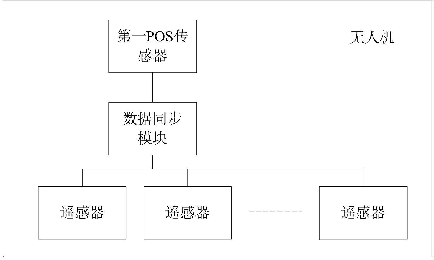
[0022] The invention provides an agricultural remote sensing system, such as figure 1 As shown, the system includes:

[0023] An unmanned aerial vehicle; the position and attitude POS sensor installed on the unmanned aerial vehicle, a plurality of different types of remote sensors and a data synchronization module, and the first POS sensor, a plurality of different types of remote sensors and the described The data synchronization module is connected;

[0024] The data synchronization module is used to generate a collection trigger signal, and input the generated collection trigger signal to the first POS sensor and multiple remote sensors;

[0025] The ...


PUM


Abstract

The invention provides an agricultural remote sensing system. Remote sensors, a POS sensor and a data synchronizing device are carried on an unmanned aerial vehicle, accordingly, images meeting the spatial resolution requirement can be obtained by controlling the flight height of the unmanned aerial vehicle, and geometric splicing is conducted on the images according to the position information recorded by the POS sensor to obtain an agricultural remote sensing image in a large area. Meanwhile, a plurality of remote sensors of different types can be carried on an unmanned aerial vehicle platform at the same time, and different types of image information can be acquired at one time. On the other hand, according to the agricultural remote sensing system, the remote sensors collect the remote sensing images once after receiving collection triggering signals, in this way, the phenomenon that the remote sensors are always in the working state can be avoided, and power supply consumption of the unmanned aerial vehicle is reduced.

Description

technical field [0001] The invention relates to the technical field of remote sensing, in particular to an agricultural remote sensing system. Background technique [0002] With the rapid development of agricultural informatization, more abundant information is urgently needed to guide the precise decision-making of fertilizer and water in the field. Traditional field surveys are limited by the number of sample points and workload, so it is difficult to cover continuously in time and space, and there is insufficient representation in time and space of "replacing areas with points". Satellite remote sensing observations can achieve continuous coverage in space, but usually due to the relatively low spatial resolution of pixels. Low, it is difficult to obtain accurate information in farmland communities, and due to the long revisit cycle of satellite data, data cannot be obtained in time; manned aerial remote sensing has high data acquisition costs, and under the strict condit...

Claims


Application Information

Patent Timeline
Patent Type & Authority Applications(China)
IPC IPC(8): G06T5/50G01N21/25
CPCH04N7/185B64C39/024B64U2101/30H04N23/11B64U10/10B64U30/20G01S5/0247H04N5/06H04N7/188
Inventor 赵春江杨贵军徐波于海洋冯海宽
Owner BEIJING RES CENT FOR INFORMATION TECH & AGRI
Why Eureka
Try Eureka