
Method for implementing complementation and fusion of image tracking measurement data and radar measurement data

A technology of image tracking and measurement data, which is applied in the field of complementary fusion of image tracking measurement data and radar measurement data, which can solve the problem of false tracks in the near-air area of ​​radar, difficulties in identification and processing of false tracks, and measurement accuracy of false target approaches, etc. problem, to achieve the goal of accurate identification and processing, high precision, and the effect of blind filling

Active Publication Date: 2014-09-24
SHENYANG AIRCRAFT CORP
View PDF5 Cites 14 Cited by
  • Summary
  • Abstract
  • Description
  • Claims
  • Application Information

AI Technical Summary

Problems solved by technology

[0002] Due to the characteristics of the radar itself, the interference of the erection environment and transmission, etc., there are problems such as false tracks, false targets, and insufficient approach measurement accuracy in the near-air area of ​​​​the radar. It is difficult to identify and deal with false tracks, which seriously affects the command performance. analyze

Method used


Image

  • Method for implementing complementation and fusion of image tracking measurement data and radar measurement data
  • Method for implementing complementation and fusion of image tracking measurement data and radar measurement data
  • Method for implementing complementation and fusion of image tracking measurement data and radar measurement data

Examples


Embodiment Construction

[0021] Theoretical basis and working principle that the inventive method realizes:

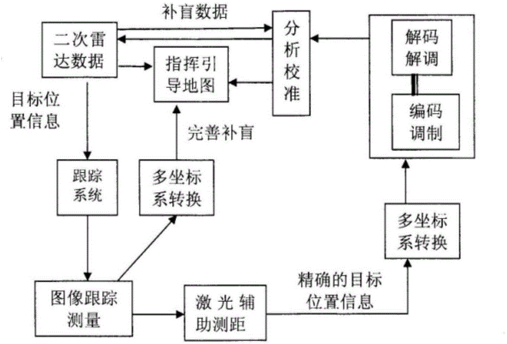
[0022] (1) Theoretical basis: Use advanced technologies and methods such as signal filter design, multi-coordinate system conversion, and laser ranging to optimize the short-range and far-range signals of the secondary radar and reduce false targets caused by multipath interference and reflection. Utilize the optimized secondary radar signal to guide the aircraft monitoring, guidance and tracking system to aim at the target more accurately, expand the working distance of the aircraft monitoring, guidance and tracking system, and encode the height, angle, heading and speed information of the video measurement aircraft into radar signals format, access to the command system, and play the role of low-altitude supplementary blindness in the vicinity of the airport.

[0023] (2) Working principle: When the radar receives the target data at a long distance, it demodulates the position information of...


PUM


Abstract

A method for implementing complementation and fusion of image tracking measurement data and radar measurement data includes the steps of firstly, conducting demodulation to obtain position information of a target and driving an image tracking system to aim at the target when receiving target data through radar from a distance; secondly, pulling the target to an effective area of a screen, collecting video image information to conduct image tracking measurement, and perfecting a command and guide map; thirdly, assisting in distance measurement judgment through a coaxial laser distance measurement instrument while conducting image tracking measurement, and conducting demodulation to obtain the accurate position information of the target; fourthly, replacing drive data of the command and guide map with identified high-accuracy data after data accuracy verification and judgment are conducted on radar detection target parameters, extrapolation data images and tracking measurement data; fifthly, using an optimized secondary radar signal for guiding an aircraft monitoring, guiding and tracking system to more accurately aim at the target, and expanding the action distance of the aircraft monitoring, guiding and tracking system. By means of the method, fake tracks of the target in near-field flight can be identified and processed, and blind area coverage can be achieved.

Description

technical field [0001] The invention relates to a technical method for the complementary fusion of image tracking measurement data and radar measurement data, which is suitable for research on track processing and data accuracy algorithms in command and guidance maps, and belongs to the related technical field of airport radar data fusion processing. Background technique [0002] Due to the characteristics of the radar itself, the interference of the erection environment and transmission, etc., there are problems such as false tracks, false targets, and insufficient approach measurement accuracy in the near-air area of ​​​​the radar. It is difficult to identify and deal with false tracks, which seriously affects the command performance. analyze. Contents of the invention [0003] In order to solve the above existing technical problems, the present invention provides a technical method suitable for complementary fusion of image tracking measurement data and radar measuremen...

Claims


Application Information

Patent Timeline
IPC IPC(8): G08G5/00
Inventor 王小凌史文浩
Owner SHENYANG AIRCRAFT CORP
Learn More