Regional ground settlement monitoring method based on multiple track and long strip CTInSAR (coherent target synthetic aperture radar interferometry)

A technology of ground subsidence and long strips, which is applied in the directions of measuring devices, surveying and navigation, height/horizontal measurement, etc., and can solve problems such as low-frequency characteristic errors

Inactive Publication Date: 2014-10-29
CHINA AERO GEOPHYSICAL SURVEY & REMOTE SENSING CENT FOR LAND & RESOURCES
View PDF4 Cites 24 Cited by
  • Summary
  • Abstract
  • Description
  • Claims
  • Application Information

AI Technical Summary

Problems solved by technology

[0008] The purpose of the present invention is to obtain full-coverage, high-precision regional land subsidence information at the same time, and solve two main problems encountered by InSAR in large-area deformation investigation and monitoring. One is how to weaken the baseline in the deformation information extraction process. Errors, atmospheric fluctuations, and phase unwrapping noises, etc., in the spatial domain show obvious low-frequency characteristics as the range increases; the second is how to accurately register the deformation monitoring results of adjacent orbits on the spatial position, and unify different Reference Datum for Deformation Measurement Between Tracks

Method used


Image

  • Regional ground settlement monitoring method based on multiple track and long strip CTInSAR (coherent target synthetic aperture radar interferometry)
  • Regional ground settlement monitoring method based on multiple track and long strip CTInSAR (coherent target synthetic aperture radar interferometry)
  • Regional ground settlement monitoring method based on multiple track and long strip CTInSAR (coherent target synthetic aperture radar interferometry)

Examples


Embodiment Construction

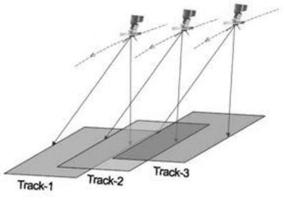
[0084] Taking the main subsidence areas of Beijing and Tianjin as an example, the specific steps of the present invention in implementation are illustrated.

[0085] During the implementation process, the ENVISAT radar data (IS2, strip mode) that completely covered the main subsidence areas of Beijing and Tianjin were used, involving three tracks, Track-218, Track-447 and Track-175. The adjacent relationship of the three tracks is as follows figure 1 As shown, the processing length of each strip is 200km, the width is 100km, and the horizontal overlap between the strips is about 40%. The radar data are acquired from December 2007 to January 2009. The radar data acquisition time used is shown in Table 1:

[0086] Table 1 Radar Data List

[0087]

Track-218

Track-447

Track-175

1

20071219

20080104

20080120

2

20080123

20080208

20080330

3

20080227

20080314

20080504

4

20080402

20080418

...


PUM


Abstract

Disclosed is a regional ground settlement monitoring method based on multiple track and long strip CTInSAR (coherent target synthetic aperture radar interferometry). The regional ground settlement monitoring method based on the multiple track and long strip CTInSAR includes seven steps: step 1, partitioning long strip radar data and performing accurate registration on the long strip radar data after being partitioned; step 2, generating a differential interference stripe atlas; step 3, removing track remnant phase positions; step 4, performing CTInSAR timing sequence analysis; step 5, examining and correcting adjacent partitioning blocks of a long strip; step 6, unifying coordinate systems of multiple tracks; step 7, examining information of the multiple tacks and unifying basis references. The regional ground settlement monitoring method based on the multiple track and long strip CTInSAR solves the two main problems that how to reduce error influences of base line error, atmospheric oscillation, phase unwrapping noise and the like, which show obvious low frequency characteristics along with range enlargement in a spatial domain during the deformation information extraction process and how to perform the accurate registration on deformation monitoring results of the adjacent tracks on space positions, which are encountered during the large region deformation survey and monitor process of InSAR (synthetic aperture radar interferometry), and unifies the basis references of deformation measurement among the different tracks.

Description

technical field [0001] The invention relates to a regional land subsidence monitoring method integrating multi-track and long-strip CTInSAR (Coherent Target SAR Interferometry, coherent target synthetic aperture radar interferometry), belonging to the technical application field of synthetic aperture radar interferometry (InSAR). It overcomes the problems of error propagation and reference deviation in the process of large-area CTInSAR data processing, and achieves high-precision investigation and monitoring of regional land subsidence. Background technique [0002] At present, there is a large-scale land subsidence in China. The three main subsidence areas of the North China Plain, the Yangtze River Delta, and the Fenwei Valley have an impact area of ​​more than tens of thousands of square kilometers, and have the characteristics of further expanding and contiguous distribution. In other areas such as Jianghan Plain, Songnen Plain, Lower Liaohe River and Pearl River Delta, ...

Claims


Application Information

Patent Timeline
Patent Type & Authority Applications(China)
IPC IPC(8): G01S13/90G01C5/00
CPCG01C5/00G01S13/9023
Inventor 葛大庆张玲王艳郭小方王毅
Owner CHINA AERO GEOPHYSICAL SURVEY & REMOTE SENSING CENT FOR LAND & RESOURCES
Why Eureka
Try Eureka