Technological method for achieving soil water content classified identification through geological radar technology

A technology of soil water content and geological radar, which is applied in the field of classification and identification of soil water content by geological radar technology, can solve problems such as the inability to accurately and quickly realize soil water content classification, and achieve accurate and efficient technical means, cost saving, and rapid automatic identification Effect

Inactive Publication Date: 2014-11-12
CHINA UNIV OF MINING & TECH (BEIJING)
View PDF3 Cites 11 Cited by
  • Summary
  • Abstract
  • Description
  • Claims
  • Application Information

AI Technical Summary

Problems solved by technology

[0004] The purpose of the present invention is to provide a technical method for geological radar technology to realize the classification and identification of soil water content in view of the shortcomings of geological radar detection that cannot accurately and quickly realize the classification of soil water content

Method used


Image

  • Technological method for achieving soil water content classified identification through geological radar technology
  • Technological method for achieving soil water content classified identification through geological radar technology
  • Technological method for achieving soil water content classified identification through geological radar technology

Examples


Embodiment Construction

[0028] Below in conjunction with accompanying drawing and embodiment the present invention will be described in further detail:

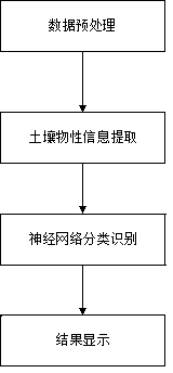
[0029] figure 1 It is a block diagram of the data processing and interpretation flow chart of the geological radar technology of the present invention to realize the technical method of classification and identification of soil water content. The specific implementation details of each step are as follows:

[0030] 1. Data preprocessing

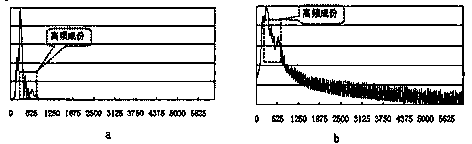
[0031] The purpose of data preprocessing is to remove various interference signals before extracting soil water content information, so as to ensure the reliability of soil water content response feature extraction. Figure 5 is the original data section image collected by ground radar, Image 6 is the preprocessed ground radar profile image, the specific implementation is as follows:

[0032] First, the zero-line correction is performed on the collected geological radar data to remove the signal drift noise of...


PUM


Abstract

The invention discloses a technological method for achieving soil water content classified identification through a geological radar technology. The technological method comprises the four parts of data preprocessing, soil water content parameter extraction, neural network classified identification and result display. Data preprocessing comprises the steps of null line correction, wavelet transformation and lowpass filtering. Soil water content parameter extraction comprises the steps that the power spectrum of reflection signals is solved with an autoregression moving average spectrum estimation method, data normalization is conducted, feature vectors and feature values of the power spectrum are extracted with a principle component analyzing method, and a sample feature vector database is constructed. Neural network classified identification comprises the steps that a neural network is trained through sample feature vectors, the trained mature network is used for conducting classified identification on data to be identified. Result display comprises the step that classified results are mapped and displayed. According to the technological method for achieving soil water content classified identification through the geological radar technology, automatic fast classified identification of the water content of soil is achieved, and a guiding function is performed on land detection and land rehabilitation.

Description

technical field [0001] The invention relates to geological radar data processing and interpretation technology, in particular to a technical method for realizing the classification and identification of soil water content by geological radar technology. Background technique [0002] Ground radar technology is a science of underground target detection by emitting high-frequency pulsed electromagnetic waves (frequency range 106~109Hz). Geological radar has the characteristics of simple operation, high detection accuracy, no damage, and fast acquisition speed. It is currently the most active technical method for engineering inspection and survey, and its application in geotechnical engineering is becoming more and more extensive. [0003] In theory, the processing of GPR data belongs to the category of digital signal processing and interpretation. Comprehensive explanation methods mainly include direct explanation method and indirect explanation method. The direct method is t...

Claims


Application Information

Patent Timeline
Patent Type & Authority Applications(China)
IPC IPC(8): G06N3/02G06N3/08G01N33/04G01V3/12G01S13/88
Inventor 杨峰杜翠乔旭冯泽权夏云海
Owner CHINA UNIV OF MINING & TECH (BEIJING)
Why Eureka
Try Eureka