A Method of Retrieving Sea Surface Wind Direction Based on Relative Radiation Correction for Navigation Radar Images

A technology of relative radiation correction and navigation radar, which is applied in the field of inversion of sea surface wind direction based on navigation radar image based on relative radiation correction, and can solve problems such as inapplicability

Active Publication Date: 2017-09-08
HARBIN ENG UNIV
View PDF2 Cites 0 Cited by
  • Summary
  • Abstract
  • Description
  • Claims
  • Application Information

AI Technical Summary

Problems solved by technology

Combined with the nonlinear attenuation characteristics of the radial echo of the navigation radar and the static characteristics of the wind streaks, it is found that the two existing methods in the second step are not applicable

Method used


Image

  • A Method of Retrieving Sea Surface Wind Direction Based on Relative Radiation Correction for Navigation Radar Images
  • A Method of Retrieving Sea Surface Wind Direction Based on Relative Radiation Correction for Navigation Radar Images
  • A Method of Retrieving Sea Surface Wind Direction Based on Relative Radiation Correction for Navigation Radar Images

Examples


specific example

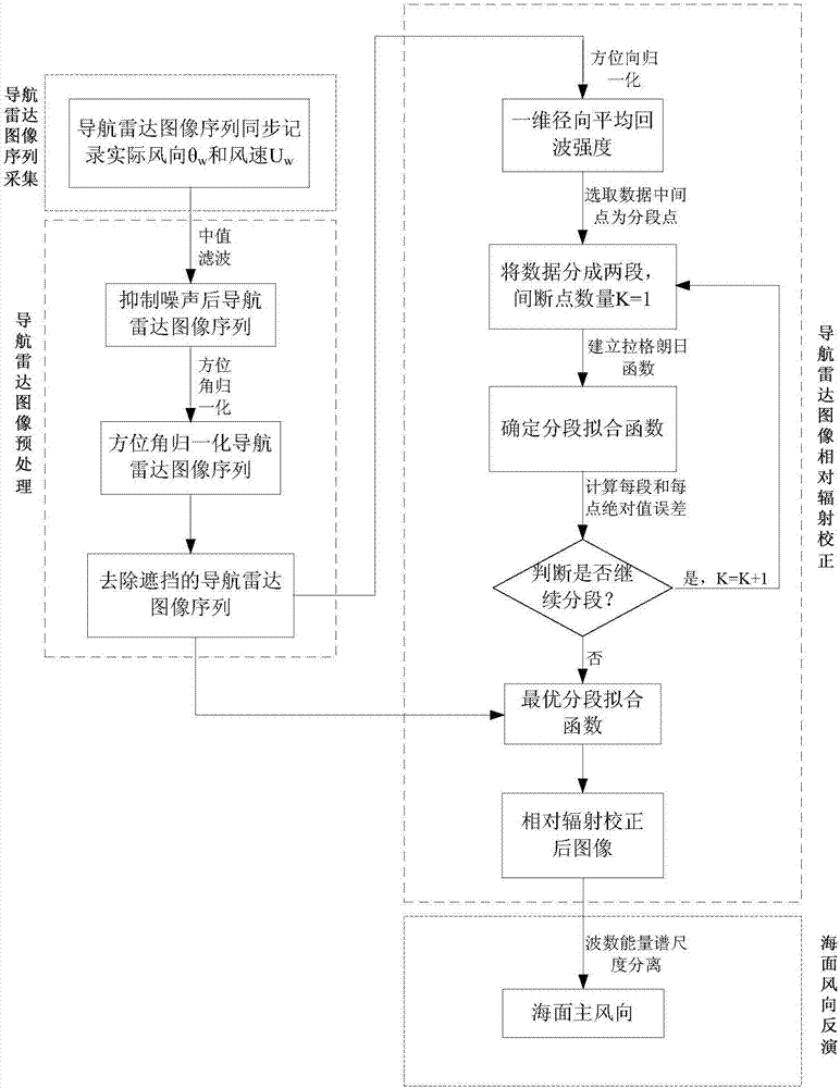
[0152] The specific implementation steps are divided into fifteen steps. The first step is the navigation image sequence acquisition; the second step to the fourth step is the navigation radar image preprocessing; the fifth step to the tenth step is the relative radiation correction of the navigation radar image; the eleventh step From step 1 to step 15, sea surface wind direction information is extracted based on wave number energy spectrum domain scale separation. Specific steps are as follows:

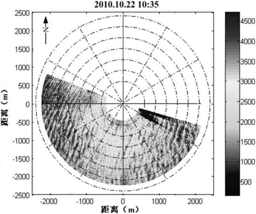
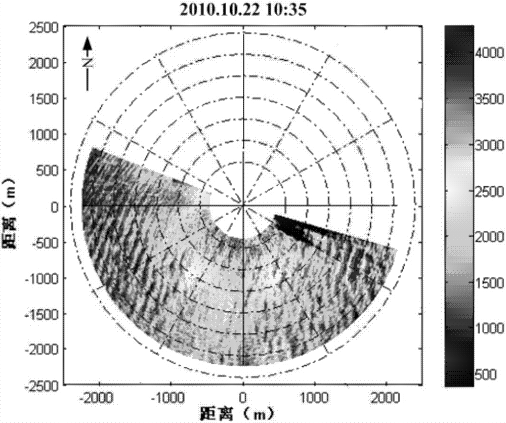
[0153] The first step is to collect 32 navigation radar images with the same position and continuous time, which is defined as a navigation image sequence, and the total length of recording time is T (about 1.5 minutes), and the wind direction θ obtained by the wind vane is simultaneously recorded simultaneously. w , the wind speed U measured by the anemometerw . Take the navigation radar image sequence at 10:35 on October 22, 2010 as an example. At this time, the wind direction is...


PUM


Abstract

The invention aims to provide a method for inversing the sea wind direction through navigation radar images based on relative radiation correction. The method comprises navigation radar image sequence collection, navigation radar image preprocessing, navigation radar image relative radiation correction and sea wind direction reversing. According to the method, the navigation radar image relative radiation correction link is added to the wind direction inversing process through wind stripes, and influence of radial damping of the navigation radar echo intensity on wind direction inversing is eliminated effectively. A self-adaptive Lagrange least square segmentation fitting correction method is adopted for the navigation radar image relative radiation correction, so that it is guaranteed that sea clutter image features are not destroyed after correction is conducted, and applicability of engineering is improved as well.

Description

technical field [0001] The invention relates to a method for retrieving sea surface wind direction. Background technique [0002] Sea surface wind field information is an important parameter of ocean dynamics and the main driving force for the exchange of energy and gas between the ocean and the atmosphere. Therefore, understanding and mastering the information of sea surface wind field has far-reaching significance for fishery, marine transportation and meteorological monitoring. The existing sea surface wind direction information acquisition methods are mainly divided into two categories: site-based on-site measurement and remote sensing measurement. Navigation radar is a kind of remote sensing measurement method. Because it has the advantages of not being affected by light and weather, real-time continuous feedback, high resolution and convenient use, it has become a hot topic for extracting sea surface wind direction information at this stage. [0003] At present, navi...

Claims


Application Information

Patent Timeline
Patent Type & Authority Patents(China)
IPC IPC(8): G06F19/00G06T7/00G01S13/89G01S13/95
CPCY02A90/10
Inventor 卢志忠王慧黄玉吕杰邱海洋戴运桃
Owner HARBIN ENG UNIV
Why Eureka
Try Eureka