Local positioning method and system based on satellite orbit information

A technology of satellite orbit and positioning method, which is applied in the field of local positioning technology based on satellite orbit information, which can solve problems such as unusable, inconvenient, and difficult real-time positioning, and achieve the effect of speeding up positioning and ensuring rapidity

Inactive Publication Date: 2014-12-03
SHANGHAI BEIGA NAVIGATION TECH CO LTD
View PDF5 Cites 24 Cited by
  • Summary
  • Abstract
  • Description
  • Claims
  • Application Information

AI Technical Summary

Problems solved by technology

[0003] However, when the environment is relatively harsh or the weather is relatively extreme, situations such as abnormal signals or no signal reception may occur from time to time, and the realization of these positioning system functions requires the help of the network from time to time. The current A-GNSS (Global Because there is no ephemeris extrapolation, the satellite navigation aid system) service can only obtain the current service (obtain ephemeris information) within a short period of time (2 ho

Method used


Image

  • Local positioning method and system based on satellite orbit information
  • Local positioning method and system based on satellite orbit information
  • Local positioning method and system based on satellite orbit information

Examples


Embodiment Construction

[0024] In order to make the object, technical solution and advantages of the present invention clearer, various embodiments of the present invention will be described in detail below in conjunction with the accompanying drawings. However, those of ordinary skill in the art can understand that, in each implementation manner of the present invention, many technical details are provided for readers to better understand the present application. However, even without these technical details and various changes and modifications based on the following implementation modes, the technical solution claimed in each claim of the present application can be realized.

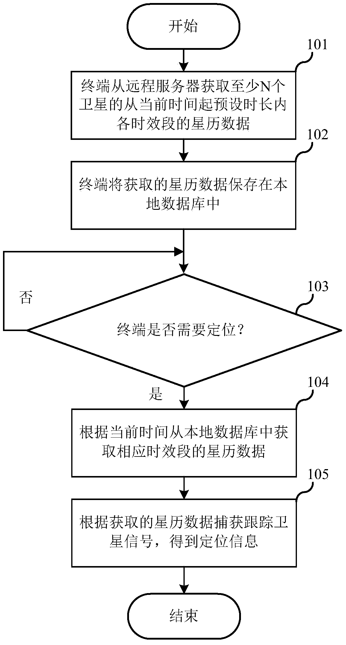
[0025] The first embodiment of the present invention relates to a local positioning method based on satellite orbit information. The specific process is as figure 1 shown.

[0026] In step 101, the terminal acquires ephemeris data of at least N satellites from a remote server within a preset period of time from the current...


PUM


Abstract

The invention relates to navigational positioning systems, and discloses a local positioning method and system based on satellite orbit information. A terminal acquires ephemeris data, in all time periods within the preset time length from the current time, of at least N satellites from a server, wherein N is larger than or equal to four. The terminal stores the acquired ephemeris data in a local database, when positioning information of the terminal needs to be acquired, the ephemeris data in the corresponding time periods are acquired from the local database according to the current time, satellite signals are captured and traced according to the ephemeris data acquired from the local database, local coordinates are calculated according to the captured and traced satellite signals, and the positioning information of the terminal is obtained. The terminal with the positioning function can be precisely positioned even though the terminal is under the condition without an auxiliary positioning network or the condition of the severe environment or the extreme weather.

Description

technical field [0001] The invention relates to a navigation and positioning system, in particular to a local positioning technology based on satellite orbit information. Background technique [0002] The positioning and navigation technology based on satellite signals has developed rapidly in the past two decades, and has gradually entered people's daily life from the exclusive application field. At present, there are several sets of global satellite positioning systems in the world: the Beidou system in my country, the GPS system in the United States, the GLONASS system in Russia, and the Galileo system in cooperation between China and Europe. Whether it is GPS positioning, GLONASS positioning, Big Dipper positioning or Galileo positioning, the main control station on the ground collects the observation data and meteorological information of each monitoring station, calculates the ephemeris of each satellite and the correction number of satellite clock, according to the re...

Claims


Application Information

Patent Timeline
IPC IPC(8): G01S19/42
CPCG01S19/42
Inventor 李瑞寒吴骏文力王永平冯卫锋宋志豪迟朋段桂平刘精轶孙枫叶刘宝舒志萍李义梅蔡之君
Owner SHANGHAI BEIGA NAVIGATION TECH CO LTD
Why Eureka
Try Eureka