Method for rapidly measuring precision coordinate and elevation of ground point in area with weak CORS signals or without CORS signals

A technology of ground points and signal areas, applied in height/horizontal measurement, radio wave measurement system, satellite radio beacon positioning system, etc., can solve the problems that the CORS measurement accuracy and stability cannot meet the actual production, and achieve low cost, High precision, overcome the effect of low precision

Inactive Publication Date: 2014-12-03
GUANGDONG UNIV OF TECH
View PDF0 Cites 9 Cited by
  • Summary
  • Abstract
  • Description
  • Claims
  • Application Information

AI Technical Summary

Problems solved by technology

The direct measurement coordinates of these two methods are WGS-84 coordinates, and the elevation is the geodetic height, which cannot be directly used for engineering surveys. Both coordinates and elevation conversions are required. In weak or no CORS signal areas, the accuracy and stability of CORS measurement All can not meet the needs of actual production, in view of this situation, the present invention utilizes conventional GNSS-RTK technology, static precision point positioning technology, CGCS2000 coordinate conversion technology, multi-source gravity field data to determine the region-like geoid technology to realize weak or no Fast measurement of coordinates and elevation of ground points in CORS signal area

Method used


Image

  • Method for rapidly measuring precision coordinate and elevation of ground point in area with weak CORS signals or without CORS signals
  • Method for rapidly measuring precision coordinate and elevation of ground point in area with weak CORS signals or without CORS signals

Examples


Embodiment 1

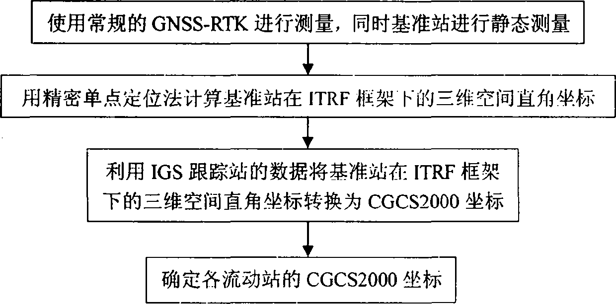
[0027] (a) Using conventional GNSS-RTK technology, first set up the base station, use the common single-point positioning method to obtain the coordinates of the base station, then start the RTK measurement mode to carry out related measurements, and obtain the relative position of the rover relative to the base station in real time, and at the same time To record the observation data of the base station, the observation time of the base station is required to be greater than 2 hours.

[0028] (b) Using GNSS precise orbit data and precise clock error data, the observation data of the reference station is post-processed for static precise single-point positioning, and the three-dimensional space Cartesian coordinates of the reference station under the ITRF framework of the average observation epoch are obtained.

[0029] (c) Select the three-dimensional Cartesian coordinates under the ITRF framework of the average observation epoch of at least three IGS tracking stations near th...


PUM


Abstract

The invention discloses a method for rapidly measuring the precision coordinate and the elevation of a ground point in an area with weak CORS signals or without CORS signals and belongs to the field of geodetic surveying. In the area with weak CORS signals or without CORS signals, the effectiveness, the stability, and the precision of CORS technology cannot satisfy the requirement of actual production. Accordingly, the invention provides the method for rapidly measuring the precision coordinate and the elevation of a ground point in an area with weak CORS signals or without CORS signals. The method comprises: acquiring the coordinate, in an ITRF framework, of a ground point at an average observation epoch moment by means of a method combining static measurement with dynamic measurement; acquiring a precise national CGCS2000 coordinate by using datum transformation; acquiring a full-frequency-domain quasigeoid model with a certain resolution by using data of earth gravitational field models with different precisions and resolutions, digital terrain models, and a certain amount of optimized GNSS/ benchmark so as to achieve elevation transformation and the normal height of the ground point. The method has characteristics of fast speed, high precision, and good stability, and has a high application value.

Description

technical field [0001] The invention relates to a method for realizing rapid measurement of precise coordinates and elevation of ground points in areas with weak or no CORS signals, and belongs to the field of geodetic surveying. Background technique [0002] Global Navigation Satellite System (GNSS), as a revolutionary development of surveying and mapping technology in the new century, has brought about earth-shaking changes in surveying and mapping technology. According to different data processing methods, GNSS measurement is divided into static measurement and dynamic measurement. Static measurement has high precision, but it has disadvantages such as long data processing time, time-consuming, and high cost. Therefore, static measurement is often used for high-precision control measurement at various levels. There are two main methods for dynamic measurement: 1. The method of setting the base station, that is, the carrier phase of the base station and the rover station ...

Claims


Application Information

Patent Timeline
Patent Type & Authority Applications(China)
IPC IPC(8): G01S19/45G01C5/00
CPCG01C5/00G01S19/45
Inventor 张兴福陈运贵谭衍涛王国辉魏德宏
Owner GUANGDONG UNIV OF TECH
Why Eureka
Try Eureka