Location information quick search method based on mask technology and subdivision coding

A technology of location information and subdivision coding, applied in geographic information databases, structured data retrieval, instruments, etc., can solve the problem of huge conversion cost, achieve the effect of low algorithm complexity, reduce the amount of matching, and improve the retrieval speed

Active Publication Date: 2014-12-03
PEKING UNIV
View PDF3 Cites 8 Cited by
  • Summary
  • Abstract
  • Description
  • Claims
  • Application Information

AI Technical Summary

Problems solved by technology

For example: Gaode's grid code cannot be used by Kay Rucker at all, and the conversion between the two is cos

Method used


Image

  • Location information quick search method based on mask technology and subdivision coding
  • Location information quick search method based on mask technology and subdivision coding
  • Location information quick search method based on mask technology and subdivision coding

Examples


Embodiment 1

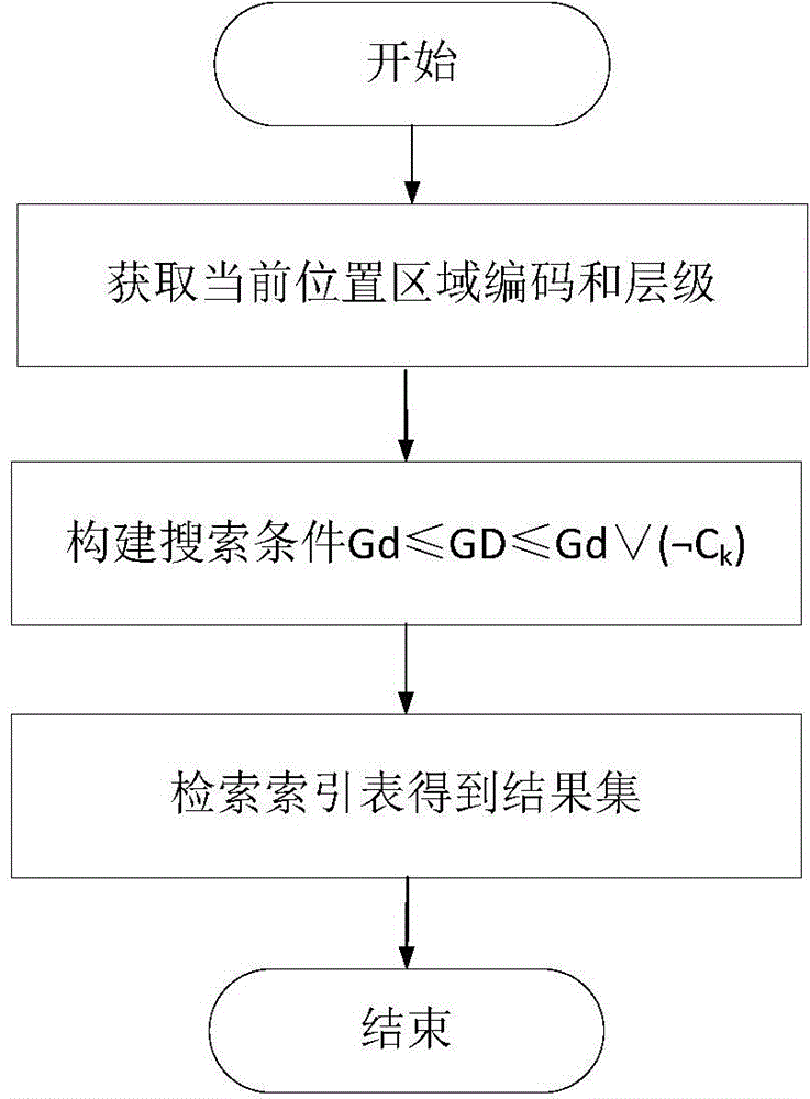
[0035] In order to realize fast retrieval of location information, the technical solution of the method may include the following steps:

[0036] Step 1. In the GeoSOT subdivision and coding scheme, create a layer mask C corresponding to each layer j j , C j It is consistent with the GeoSOT code length of the 32nd level, and the bits corresponding to levels 1~j are all 1, and the remaining bits are 0; 1≤j≤32. For example, the level mask of level 14 expressed in quaternary is 33333333333333000000000000000000.

[0037] Step 2. For the search area, select a subdivision patch set related to the search area in the GeoSOT subdivision and coding scheme, and the GeoSOT code of the subdivision patch p in the subdivision patch set is Gd p ; Obtain the search result for each subdivision patch p in the subdivision patch set: perform logic negation on the hierarchical mask of the subdivision patch p and then combine it with Gd p Perform a logical OR operation to obtain the code G of the...

Embodiment 2

[0046] Embodiment 2, for the above-mentioned first case:

[0047] Then, in the GeoSOT subdivision and coding scheme, the subdivision patch set that is associated with the retrieval area is selected as follows: a subdivision patch A that completely covers the retrieval area is selected. That is, at this time, the subdivision patch set associated with the retrieval area only includes one subdivision patch.

[0048] Then the GeoSOT code of A is Gd. In this embodiment, Gd is selected as a quaternary code. In practical applications, Gd can be converted into any code, and Gd is specifically Gd 1 d 2 d 3 … d k , where d k is 0, 1, 2 or 3, k is an integer and 1≤k≤32, k is the level of the above-mentioned subdivision patch A, the index number in the index table is GD, and the level mask of the kth level is C k .

[0049] At this time, for step 3 in embodiment 1, the following query method can be adopted:

[0050] Query the GeoSOT coded GD that meets the following conditions, an...

Embodiment 3

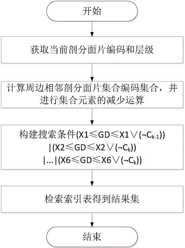
[0053] Embodiment 3, for the above-mentioned second situation:

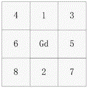
[0054] In the GeoSOT subdivision and coding scheme, the subdivision patch set that is associated with the retrieval area is selected as: the smallest subdivision patch A covering the retrieval area in the GeoSOT subdivision and coding scheme 0 , A 0 The level is k, find 8 adjacent subdivision patches A with level k around the smallest subdivision patch 1 ~A 8 , by A 0 ~A 8 Composition of subdivision facet set, specifically as figure 2 shown. That is, at this time, the subdivision patch set associated with the retrieval area includes 9 subdivision patches.

[0055] Based on the set A, step 3 in embodiment 1 can adopt the following retrieval process:

[0056] Set up the subdivision patch A 0 ~A 8 The corresponding GeoSOT code is Gd 0 ~Gd 8 , use the following query conditions to obtain the qualified GD, and use the qualified GD to retrieve the areas or objects in the surrounding area of ​​the current lo...


PUM


Abstract

The invention discloses a location information quick search method based on mask technology and subdivision coding, and relates to the technical field of meshing inquiring and searching of spatial data. The method particularly comprises the following steps: aimed at a searching zone, selecting a subdivision facet set with incidence relation to the searching zone; aimed at each dissection facet p in the dissection facet set, acquiring a searching result; performing bitwise operation of logical negation on the level mask of the dissection facet p, performing logic or operation with GeoSOT coding Gdp of p, and acquiring a coding Gmaxp of the 32th level dissection facet with the maximum GeoSOT coding value contained in the dissection facet p range; adopting the bit comparing method to search the acquired location information of the dissection facet as the searching result; finally summarizing searching results corresponding to all dissection facets in the dissection facet set. The method is applicable to searching of location information of global geographic object in meshing arrangement.

Description

technical field [0001] The invention relates to the technical fields of geospatial information subdivision organization, navigation location service, and spatial data grid query retrieval, and in particular to a method for quickly retrieving location information by using subdivision code mask technology for code matching. Background technique [0002] At present, with the rapid development of remote sensing technology, computer technology, and satellite communication technology, and the continuous improvement of the ability to obtain spatial information, spatial data is growing explosively. The storage, organization, management and efficient retrieval of massive Earth observation data with different spatial resolutions, different spectral resolutions, and different temporal resolutions has become a crucial research content. The coordinate method (the common ones are latitude and longitude coordinates, geodetic coordinates, rectangular coordinates, etc.) is the expression met...

Claims


Application Information

Patent Timeline
IPC IPC(8): G06F17/30
CPCG06F16/2272G06F16/2454G06F16/24554G06F16/29G06F16/9537
Inventor 程承旗濮国梁王慧玲
Owner PEKING UNIV
Why Eureka
Try Eureka