Seismic exploration auxiliary data quality control method based on three-dimensional GIS

A quality control method and auxiliary data technology, applied in the direction of seismic signal processing, etc., can solve the problems of inability to collect seismic records and quality control of a large number of seismic data, lack of seismic auxiliary data quality control functions, and inability to verify the results of SPS arrangement, etc. Achieve the effects of reducing time and labor costs, improving processing efficiency and data archiving quality

Inactive Publication Date: 2015-01-14
CHINA PETROLEUM & CHEM CORP +1
View PDF4 Cites 5 Cited by
  • Summary
  • Abstract
  • Description
  • Claims
  • Application Information

AI Technical Summary

Problems solved by technology

[0005] At present, well-known acquisition software at home and abroad provide support for SPS standard seismic auxiliary data, but only some simple reading functions, lack of quality control functions for these seismic auxiliary data, cannot provide seismic data acquisition for a large number of seismic data and wide line , ultra-long file numbers for sorting and quality control of seismic records, and it is also impossible to use virtual 3D terrain scenes to verify SPS sorting results

Method used


Image

  • Seismic exploration auxiliary data quality control method based on three-dimensional GIS
  • Seismic exploration auxiliary data quality control method based on three-dimensional GIS
  • Seismic exploration auxiliary data quality control method based on three-dimensional GIS

Examples


Embodiment Construction

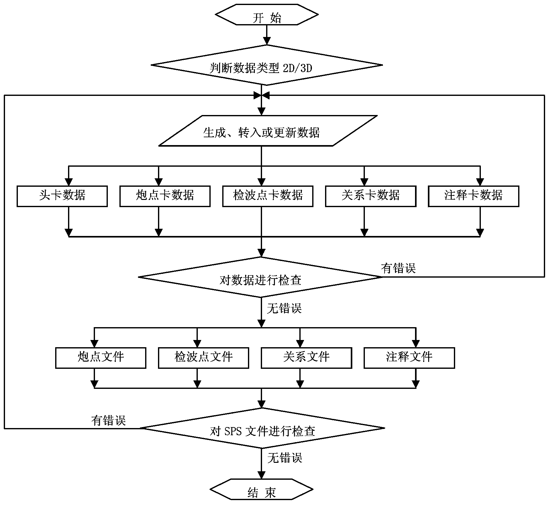
[0025] Below in conjunction with accompanying drawing, the present invention is described in further detail:

[0026] The invention provides a three-dimensional GIS-based seismic exploration auxiliary data quality control method, which belongs to the field of petroleum exploration and development. The method of the present invention includes: (1) format analysis and batch input of multi-version land three-dimensional seismic exploration auxiliary data (corresponding to figure 1 "Generate, transfer or update data" step); (2) establish a global geographic projection coordinate system conversion layer to realize the conversion of shot points and receiver points from Beijing 54 to WGS84 coordinate system; (3) convert the seismic survey The imagery point data analyzed in the auxiliary data format is converted into a KML format file that can be recognized by Google Earth; (4) The imagery point data in KML format is directly placed on the three-dimensional earth, and the SPS result d...


PUM


Abstract

The invention provides a seismic exploration auxiliary data quality control method based on three-dimensional GIS, which belongs to the field of seismic exploration and development. According to the method of the invention, three-dimensional GIS is applied on seismic exploration auxiliary data quality control. In combination with high-resolution satellite images and aerial pictures, visual pattern monitoring is performed on the field seismic exploration auxiliary data, thereby improving a data processing efficiency and a data filing quality. The seismic exploration auxiliary data quality control method can improve SPS data processing efficiency and the data filing quality, and furthermore reduces time and manpower cost caused by actual exploration at the construction field.

Description

technical field [0001] The invention belongs to the field of seismic exploration and development, in particular to a three-dimensional GIS-based seismic exploration auxiliary data quality control method. Background technique [0002] The main functions of seismic exploration auxiliary data quality control are divided into two parts. One is to generate standard format SPS header card and data card through operations such as text file transfer, data update, batch input, and relational calculation; the other is to standardize the input format. The SPS file can be analyzed graphically by displaying the observation system, plane position, and various curves, and can monitor the quality of the SPS file in an all-round way through the checking function of the format and corresponding relationship. [0003] At present, the major oil companies in the world all adopt the seismic exploration auxiliary data format recommended by SEG, among which the SPS format is the most widely used st...

Claims


Application Information

Patent Timeline
Patent Type & Authority Applications(China)
IPC IPC(8): G01V1/28G01V1/32
Inventor 王昀陈浩岳承琪洪承煜吴边
Owner CHINA PETROLEUM & CHEM CORP
Why Eureka
Try Eureka