Seamless visualization method for three-dimensional virtual reality system and geographic information system

A geographic information system, three-dimensional virtual technology, applied in image data processing, 3D image processing, instruments, etc., can solve user obstacles and troubles, reduce the readability, ease of use, abstraction and Confusion, confusion and disjointness of concrete information

Active Publication Date: 2015-03-25
北京微视威信息科技有限公司
View PDF2 Cites 47 Cited by
  • Summary
  • Abstract
  • Description
  • Claims
  • Application Information

AI Technical Summary

Problems solved by technology

[0009] The above-mentioned visualization methods of both 2D GIS and 3D GIS systems with 3D visualization functions may cause confusion, disorder, and disconnection between the abstr...

Method used


Image

  • Seamless visualization method for three-dimensional virtual reality system and geographic information system
  • Seamless visualization method for three-dimensional virtual reality system and geographic information system
  • Seamless visualization method for three-dimensional virtual reality system and geographic information system

Examples


Embodiment Construction

[0054] In order to make the above objects, features and advantages of the present invention more obvious and understandable, the present invention will be further described below through specific embodiments and accompanying drawings.

[0055] 1. Difficulties and basic ideas

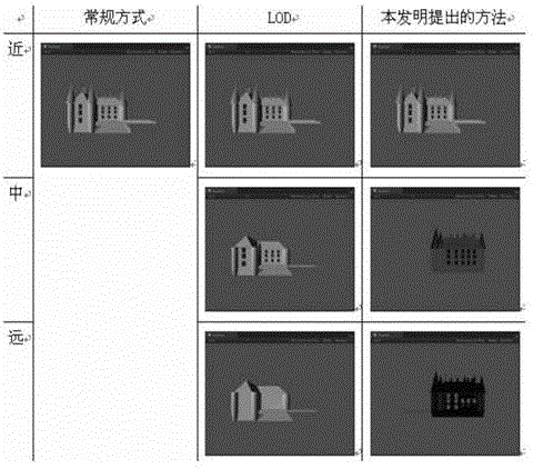
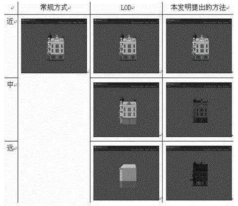
[0056] Information overload and visual clutter is a cognitive problem often encountered in the visualization of large-scale 3D urban scenes in GIS using graphical and virtual reality methods. In large-scale 3D urban scenes, due to the presence of 3D models of buildings with a large number of visual details, the visual information transmitted to users is too rich, which leads to cognitive difficulties for users (for example, when paying attention to a certain area, the attention is always being interfered by other buildings around the area). At present, on this issue, the Focus+Context Visualization strategy is generally adopted, which is a kind of visualization method that highlights the content in the ...


PUM


Abstract

The invention relates to a seamless visualization method for a three-dimensional virtual reality system and a geographic information system. The method comprises the steps that in a preprocessing stage, a three-dimensional model in the three-dimensional geographic information system is processed, and two-dimensional map symbols which are represented according to carpological standards are generated; in a real-time visualization stage of a three-dimensional geographic scene, in the process that a camera roams and observes the scene from near to far, a hierarchy selection technology is adopted to enable the three-dimensional model to conduct switching transition of multi-resolution level details from an exquisite layer to a rough layer until the roughest layer; with the distance between the camera and the three-dimensional model being further enlarged to a certain extent, the three-dimensional model is transited to a billboard through a Morph technology in a seamless mode and finally transited to the pre-generated two-dimensional map symbols in a seamless mode; the visualization process of the camera from far to near is opposite to the switching transition process from near to far. The seamless visualization method can achieve a seamless transition visual fusion effect, and meets the requirements of a user for multi-dimensional and polymorphous comprehensive perception and acknowledge of geographic information.

Description

technical field [0001] The invention belongs to the field of virtual reality technology and geographic information technology, and in particular relates to a seamless visualization method of a three-dimensional virtual reality system and a geographic information system. Background technique [0002] Real-time visualization of large-scale 3D complex virtual scenes is an important part of virtual reality systems, widely used in: digital earth, battlefield information visualization, large building roaming, 3D driving simulation, computer-aided industrial manufacturing, and computer games and animations, etc. Subfields are the basis of all virtual reality systems. Its goal is to provide users with a browsing environment capable of real-time interaction within a complex three-dimensional scene with a large spatial span, from which they can obtain a very high-fidelity visual experience. [0003] Geographic Information System (GIS) is a computer system for inputting, storing, quer...

Claims


Application Information

Patent Timeline
IPC IPC(8): G06T17/00G06T17/10
CPCG06T15/20G06T17/05
Inventor 李胜郭宗琪汪国平
Owner 北京微视威信息科技有限公司
Why Eureka
Try Eureka