Three-dimensional scene reconstruction method based on GPS information video

A 3D scene and video technology, applied in the field of 3D scene automatic reconstruction system based on geo-tagged video, can solve the problems of accuracy, low efficiency of 3D scene reconstruction, large amount of calculation, etc.

Active Publication Date: 2015-03-25
HEFEI UNIV OF TECH
View PDF3 Cites 7 Cited by
  • Summary
  • Abstract
  • Description
  • Claims
  • Application Information

AI Technical Summary

Problems solved by technology

[0004] One: The existing 3D scene reconstruction methods determine the matching points between frames based on geometric models in the key frame extraction process. These geometric models focus on the processing between the content level or point level of each frame of the video, resulting in The calculation process is very complicated; and relying on the reconstruction method of comparing two consecutive frames in the video, the calculation amount is relatively large, which makes the efficiency of 3D scene reconstruction relatively low;
[0005] For example, in 2010, authors such as Mirza Tahir Ahmed proposed a 3D reconstruction method in the article "Robust Key Frame Extraction for 3D Reconstruction from Video Streams" published at the international conference Computer Vision Theory and Applications. The number of corresponding points and the cost of the corresponding points between two frames to the epipolar line are used to select the key frame. Before selecting the key frame, the frame is not screened, and the reconstruction method of comparing two consecutive frames in the video is selected in turn. , resulting in a large amount of calculation and a complex mathematical model, which leads to a relatively high complexity of application and promotion;
[0006] Two: The existing 3D scene reconstruction method based on geographic information is based on the heuristic prediction of the camera position information corresponding to the video frame to achieve reconstruction, but this method leads to low reconstruction accuracy;
[0007] For example, in 2007, Philippos Mordohai and other authors mentioned in the article "Real-time Video-based Reconstruction of Urban Environments" published on the working group ISPRS that the use of global positioning system (GPS) data is the geographical location corresponding to each frame of the video. Information to complete a 3D scene reconstruction system, this method is based on heuristic prediction of the camera position corresponding to the video, and only considers the geographical location information, such as longitude and latitude; directly and simply select consecutive frames from the video stream as key frame comparison, It often exceeds the baseline of 3D scene reconstruction, and there are precision problems, which leads to poor reconstruction effect, and this method is not very practical;
[0008] Therefore, so far, there is a lack of a 3D scene automatic reconstruction technology with high reconstruction accuracy and high efficiency.

Method used


Image

  • Three-dimensional scene reconstruction method based on GPS information video
  • Three-dimensional scene reconstruction method based on GPS information video
  • Three-dimensional scene reconstruction method based on GPS information video

Examples


Embodiment Construction

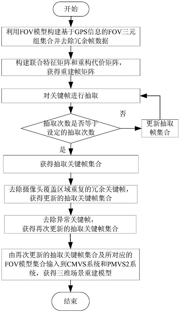
[0080] In this example, if figure 1 As shown, a kind of 3D scene reconstruction method based on video with GPS information is carried out according to the following steps:

[0081] Step 1. Build a FOV model set based on GPS information and remove redundant frame data:

[0082] Step 1.1, utilize the mobile device with camera and GPS function to obtain the video data of the M frame target scene that contains GPS information, GPS information comprises: the longitude and latitude vector of camera, the angle of elevation of camera and the angle of view of camera; Except utilizing camera and GPS Functional mobile devices can obtain video data, and video data can also be obtained through video sharing platforms with GPS information, such as GeoVid video sharing platform (http: / / api.geovid.org) to obtain video data; M frames of video data are constructed from M frames FOV (Field-Of-View, FOV for short) model triplet, so as to build a FOV model set based on GPS information, denoted as...


PUM


Abstract

The invention discloses a three-dimensional scene reconstruction method based on a GPS information video. The method comprises the following steps that 1, an FOV model set based on GPS information is constructed and redundancy frame data are removed; 2, a reconstruction frame matrix is constructed; 3, a key frame is extracted; 4, a target scene is reconstructed in a three-dimensional mode. According to the three-dimensional scene reconstruction method based on the GPS information video, the video key frame can be rapidly and accurately extracted, and therefore the precision and efficiency of the three-dimensional scene reconstruction method are improved.

Description

technical field [0001] The invention belongs to the technical fields of computer vision, computer graphics and artificial intelligence, and mainly relates to a 3D scene automatic reconstruction system based on geographic tag video. Background technique [0002] The 3D scene reconstruction method is an intelligent image analysis method. Its purpose is to obtain the spatial position data and surface texture images of objects in the real world, and to reconstruct a 3D digital model with a high degree of realism in physical size and surface features. The three-dimensional information of objects is one of the hot research topics in the field of computer vision. 3D scene reconstruction can be applied in industrial manufacturing, construction, 3D computer games, facial animation, robot navigation, visual monitoring, etc. [0003] With the development of modern sensing technology and information processing technology, 3D scene reconstruction has also been greatly developed, but it ...

Claims


Application Information

Patent Timeline
Patent Type & Authority Applications(China)
IPC IPC(8): G06T17/00
CPCG06T17/00G06T17/30
Inventor 汪萌张鹿鸣郭丹鲁志红
Owner HEFEI UNIV OF TECH
Why Eureka
Try Eureka