Method for determining three-dimensional gravity center of city based on remote-sensing image and application thereof

A city, center of gravity technology, applied in the field of image processing, can solve problems such as the inability to obtain the three-dimensional center of gravity of the city

Active Publication Date: 2015-03-25
INST OF GEOGRAPHICAL SCI & NATURAL RESOURCE RES CAS
View PDF3 Cites 12 Cited by
  • Summary
  • Abstract
  • Description
  • Claims
  • Application Information

AI Technical Summary

Problems solved by technology

[0005] However, the existing research methods of urban center of gravity can only obtain the development and changes of the two-dimensional center of gravity of the city, and cannot obtain the three-dimensional center of gravity of the city.

Method used


Image

  • Method for determining three-dimensional gravity center of city based on remote-sensing image and application thereof
  • Method for determining three-dimensional gravity center of city based on remote-sensing image and application thereof
  • Method for determining three-dimensional gravity center of city based on remote-sensing image and application thereof

Examples


Embodiment Construction

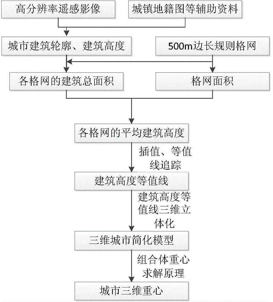
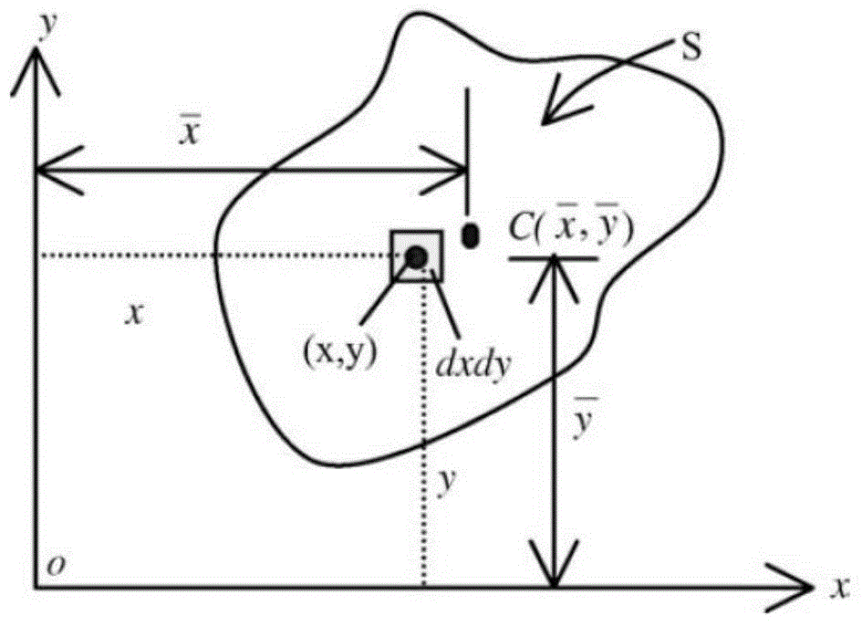
[0053] The present invention is based on the basic principle of solving the three-dimensional center of gravity. In this paper, based on the research on the extraction method of the two-dimensional center of gravity, the basic idea of ​​extracting the three-dimensional center of gravity of the city is proposed ( figure 1 ): First, based on urban high-resolution remote sensing images and auxiliary data such as urban cadastral maps and topographic maps, extract all building outlines and building heights in the city; secondly, divide the entire urban built-up area into several regular grids with appropriate side lengths, In this paper, a regular grid with a side length of 500m is selected to divide the cross-grid buildings, the total building volume in the grid is calculated according to the building outline and building height in each grid, and the average building height of each grid is calculated based on the grid area ; Again, use the inverse distance weighting method (a spat...


PUM


Abstract

The invention provides a method for determining the three-dimensional gravity center of a city based on a remote-sensing image. The method comprises the steps that the remote-sensing image of the city is utilized, urban cadastre and terrain data are combined, and the contours and corresponding heights of all buildings of the target city are extracted; then, urban building height and contour data are divided into a plurality of standard units according to preset square grids, the building height of each grid (unit) is determined, and then a building height contour line is constructed; finally, a three-dimensional model of a target area is constructed based on the building height contour line of the target area, and the three-dimensional gravity center of the target area is calculated based on the three-dimensional model. According to the method, the three-dimensional gravity center of the city or a certain area of the city can be determined accurately and fast. Due to the fact that the three-dimensional gravity center can be used for measuring the location center of the city from the angles of the plane dimension, stereoscopic height and the like, the mode of utilizing the three-dimensional gravity center for layout of a commercial center and site selection of infrastructure construction is more scientific than the mode of utilizing a two-dimensional gravity center for assisting in decision making.

Description

technical field [0001] The invention relates to the field of image processing, in particular to a method for determining a three-dimensional center of gravity of a city based on city images and an application of the method. Background technique [0002] As the most active spatial area of ​​human activities, the city's form is constantly changing in the process of urban formation and development, and it also reflects the characteristics and laws of this process. In the fields of urban construction and land management, it is necessary to grasp the development trend of the city, so as to further plan, design, and select new buildings based on the current development status of the city. In the process of studying the development trend of the city, it is very important to obtain the urban center of gravity and its changing process. [0003] Many scholars have conducted in-depth research on the evolution of urban form and the law of shifting the center of gravity. In related res...

Claims


Application Information

Patent Timeline
Patent Type & Authority Applications(China)
IPC IPC(8): G06T17/05G06T7/00G06Q50/26
CPCG06T7/66G06T17/05
Inventor 刘彦随乔伟峰王介勇王亚华项灵志
Owner INST OF GEOGRAPHICAL SCI & NATURAL RESOURCE RES CAS
Why Eureka
Try Eureka