High-accuracy target positioning method of unmanned plane on basis of multi-station measurement

A target positioning and UAV technology, applied in the field of high-precision UAV passive target positioning, can solve the problems of high cost, low applicability, unfavorable concealment, etc., to ensure its own safety, wide application range, high The effect of positioning accuracy

Inactive Publication Date: 2015-04-08
中国人民解放军63961部队
View PDF4 Cites 60 Cited by
  • Summary
  • Abstract
  • Description
  • Claims
  • Application Information

AI Technical Summary

Problems solved by technology

The accuracy of active positioning and measurement is generally high, but the laser belongs to the category of visible light, which is not conducive to its own concealment. At the same time, it is expensive to equip the photoelectric reconnaissance platform
Passive positioning collects target images through cameras, and uses image analysis algorithms to obtain target positions, mainly including: target positioning based on image matching mode. This method uses available multi-source image resources. The corrected UAV TV image is matched with the reference picture to achieve target positi

Method used


Image

  • High-accuracy target positioning method of unmanned plane on basis of multi-station measurement
  • High-accuracy target positioning method of unmanned plane on basis of multi-station measurement
  • High-accuracy target positioning method of unmanned plane on basis of multi-station measurement

Examples


Embodiment Construction

[0022] A high-precision target positioning method for an unmanned aerial vehicle based on multi-station measurement of the present invention includes the following processes:

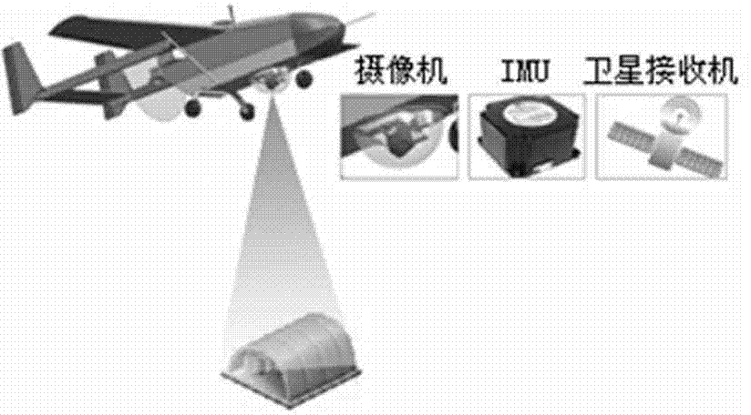
[0023] The first step is to determine that the UAV is equipped with a satellite receiver, an inertial measurement unit (IMU), a camera pan / tilt, and a camera, of which the camera pan / tilt can achieve two-degree-of-freedom motion (azimuth rotation and elevation rotation).

[0024] In the second step, before the drone takes off, the camera calibration method in the present invention is used to determine the internal parameters of the camera.

[0025] The third step is to select the target point of interest during the flight of the drone, and adjust the azimuth and elevation angles of the camera's gimbal to ensure that the target point is within the camera's field of view within a certain period of time.

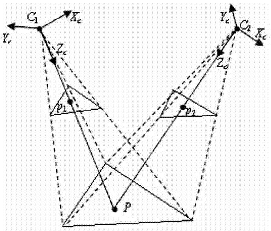
[0026] The fourth step is to extract the coordinates of the point with the same name of t...


PUM


Abstract

The invention discloses a high-accuracy target positioning method of an unmanned plane on the basis of multi-station measurement. The high-accuracy target positioning method comprises the following steps: determining a satellite receiver, an inertial measurement unit, a camera holder and a camera equipped on the unmanned plane; before the unmanned plane takes off, calibrating inner parameters of the camera; in the flying of the unmanned plane, selecting interesting target points, and adjusting the azimuth angle and the elevation angle of the camera holder to guarantee that the target points are in the viewing field in the set time; extracting out coordinates of homonymy points of targets in images shot at different times, and calculating the coordinates (X, Y, Z) of the target points in a world coordinate system; converting the (X, Y, Z) into longitude and latitude and geodetic height and finishing the target positioning process. The high-accuracy target positioning method disclosed by the invention has the advantages that a photoelectric reconnaissanle platform is not needed, and laser ranging is not needed, so that the self safety is effectively guaranteed, and the cost of measuring equipment is also reduced; simultaneously, the high-accuracy target positioning method has high positioning accuracy and wide application range, and has important practical significance in the field of high-accuracy target positioning of the unmanned plane.

Description

technical field [0001] The invention relates to a high-precision UAV passive target positioning, in particular to a high-precision UAV target positioning method based on multi-station measurement. Background technique [0002] Compared with manned aircraft, UAV has the advantages of small size, low cost, convenient use and low environmental requirements. With the improvement of the technical level, UAVs have been widely used in various fields, including reconnaissance and surveillance, rescue and disaster relief, terrain survey, target strike, etc. Target positioning is one of the important functions of the UAV, and its purpose is to obtain the three-dimensional coordinates of the target in the geodetic coordinate system. At present, high-precision UAV target positioning has become a hot spot in the field of UAV research at home and abroad. [0003] UAV target positioning can be mainly divided into active positioning and passive positioning. Active positioning is mainly b...

Claims


Application Information

Patent Timeline
IPC IPC(8): G01C11/00
CPCG01C11/00
Inventor 马传焱时荔蕙王春龙郝博雅孙宇翔高洪兴
Owner 中国人民解放军63961部队
Why Eureka
Try Eureka