Environmental status time-space model generation method and system based on digital measurable images

A technology of space-time model and real scene, applied in measurement devices, instruments, etc., can solve the problems of high professional requirements of users, inability to add, poor model interactivity, etc., to reduce the difficulty of understanding and professional requirements, simple implementation, Strong interactivity

Active Publication Date: 2015-05-06
测绘遥感信息工程国家重点实验室深圳研发中心
View PDF6 Cites 12 Cited by
  • Summary
  • Abstract
  • Description
  • Claims
  • Application Information

AI Technical Summary

Problems solved by technology

However, the collected information is stored in the industrial computer in the form of text files, which cannot be effectively used
[0003] The currently known environmental status models based on two-dimensional electronic maps or electronic graphics tables cannot intuitively reflect the real scene of the scene, and have high professional requirements for users
In addition, the known models are poor in interactivity, users can only passively receive the information expressed by the model itself, and cannot intuitively add their own evaluation and judgment to the model
Even if some known environmental monitoring technologies introduce real-scene images and related spatial information, they only treat them as independent scene information, and do not apply measurable real-scene images as a special environmental parameter to establish an environmental status model

Method used


Image

  • Environmental status time-space model generation method and system based on digital measurable images

Examples


Embodiment Construction

[0025] The technical solution of the present invention will be described in detail below with reference to the drawings and embodiments.

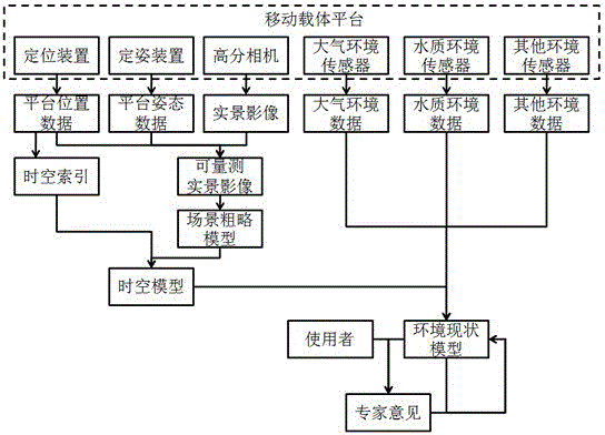
[0026] The present invention proposes to establish a spatiotemporal model of environmental status based on measurable real-world images and multiple environmental parameters, including the following parts:

[0027] 1. Environmental parameters: Obtained through environmental sensors, such as TSP, PM2.5, sulfur dioxide, nitrogen dioxide, carbon monoxide, ozone and other atmospheric environmental parameters, pH, dissolved oxygen, conductivity, turbidity and other water quality environmental parameters, noise and other Environmental parameters.

[0028] 2. Special environmental parameters-measurable real-life images: a photogrammetric product, with known internal and external elements of the three-dimensional image pair of different angles shot for the same real scene, the scene can be obtained by the method of front intersection The spatial coordina...


PUM


Abstract

The invention discloses an environmental status time-space model generation method and system based on digital measurable images. The method includes: conducting collection through a mobile carrier platform and simultaneously obtaining the environmental parameters and the digital measurable images of a real scenario in each collection position; building a time-space model of the real scenario through the digital measurable images; building a time-space sequence index through exterior orientation elements of the digital measurable images and the collection time, measuring the terrain key points of the scenario according to the digital measurable images and constituting a scenario rough model through the terrain key points; and organizing the environmental parameters according to the built time-space model, adding the marked result to the time-space model by a recording user through the marked pollution feature points and corresponding evaluation information by the digital measurable images, and obtaining outputting and displaying the environmental status time-space model of the real scenario. According to the environmental status time-space model generation method and system, the digital measurable images are regarded as a special environmental parameter used for building the environmental status time-space model, and the measurability of the digital measurable images is fully utilized.

Description

Technical field [0001] The invention relates to the field of environmental monitoring and pollution analysis, in particular to a spatio-temporal model of environmental status based on measurable real scene images and multiple environmental parameters and an acquisition method thereof. Background technique [0002] As people pay more and more attention to environmental issues and the development of environmental sensor technology, technical parameters such as the sampling frequency and detection accuracy of environmental sensors are rapidly improving. At the same time, the volume of environmental sensors is gradually miniaturized, modularized and integrated into mobile carrier platforms. Above. In addition to the traditional environmental parameters that are generally monitored, spatial information such as real scene images and position and posture has gradually attracted people's attention, and it is also collected together with environmental parameters as auxiliary data. For ex...

Claims


Application Information

Patent Timeline
Patent Type & Authority Applications(China)
IPC IPC(8): G01D21/02
Inventor 龚威林恒
Owner 测绘遥感信息工程国家重点实验室深圳研发中心
Why Eureka
Try Eureka