Viscous debris flow rectangular drainage groove depth measuring and calculating method and application
A debris flow and drainage channel technology, which is applied in water conservancy projects, sea area projects, water conservancy engineering equipment, etc., can solve the problems of limited practicality and large errors, and achieve the effect of wide applicability, avoiding subjective judgment and limited practicality
- Summary
- Abstract
- Description
- Claims
- Application Information
AI Technical Summary
Problems solved by technology
Method used
Image
Examples
Embodiment 1
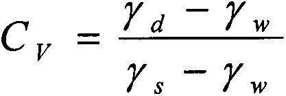
[0042] A debris flow ditch with a drainage area of 3.52km 2 , the length of the main ditch is 3.52km, the average gradient of the main ditch bed is 288‰, the altitude of the ditch mouth is 675m, the highest altitude is 1689m, and the relative height difference of the watershed is 1014m. The mudslides have caused serious harm to the bridges, cultivated land, and roads at the mouth of the ditch. In order to alleviate and eliminate debris flow disasters, a debris flow drainage channel is planned to be arranged between the mouth of the mountain exit and the main river in the basin. Using the method for measuring and calculating the depth of the viscous debris flow rectangular drainage channel of the present invention to design the depth of the drainage channel, the specific steps are as follows:
[0043] The first step is to determine the bulk density of debris fluid under the design standard through actual sampling and measurement of bulk density γ d 22.07kN / m 3 , bulk densi...
Embodiment 2
[0048] In the early morning of July 16, 2006, a large-scale debris flow broke out in Wawagou on the left bank of the Hongba River in Jiulong County, Ganzi Tibetan Autonomous Prefecture, Sichuan Province. The gate areas, workshops and water intakes of the three downstream power stations were washed away. Wawagou is located at 102°01′34″-102°05′20″ east longitude and 29°14′08″-29°17′50″ north latitude. It is located on the southeastern edge of the Western Sichuan Plateau. It is a viscous debris flow ditch and the main ditch of the watershed. 5.5km long. The basin is 2025-5014m above sea level, with a relative height difference of 2989m, and belongs to the middle-alpine-alpine landform. In order to effectively control the debris flow ditch, it is planned to arrange a debris flow drainage channel between the mouth of the mountain mouth and the main river in the basin. Using the method for measuring and calculating the depth of the viscous debris flow rectangular drainage channel...
PUM
 Abstract
Description
Claims
Application Information
 - R&D
- Intellectual Property
- Life Sciences
- Materials
- Tech Scout
- Unparalleled Data Quality
- Higher Quality Content
- 60% Fewer Hallucinations
Browse by: Latest US Patents, China's latest patents, Technical Efficacy Thesaurus, Application Domain, Technology Topic, Popular Technical Reports.
© 2025 PatSnap. All rights reserved.Legal|Privacy policy|Modern Slavery Act Transparency Statement|Sitemap|About US| Contact US: help@patsnap.com


