
Earth rock cofferdam breach flood risk mapping method

A technology of flood risk map and earth-rock cofferdam, which is applied in image data processing, instruments, calculations, etc., can solve the problem of no earth-rock cofferdam breakage and other problems.

Inactive Publication Date: 2015-07-22
WUHAN UNIV
View PDF0 Cites 8 Cited by
  • Summary
  • Abstract
  • Description
  • Claims
  • Application Information

AI Technical Summary

Problems solved by technology

Flood risk maps are mainly classified into four categories: rivers and lakes flood risk maps, flood storage and detention area flood risk maps, reservoir flood risk maps, and urban flood risk maps. However, the research is blank. At present, there is no method for compiling flood risk map of earth-rock cofferdam failure, which can directly show the literature and engineering examples of cofferdam failure loss.

Method used


Image

  • Earth rock cofferdam breach flood risk mapping method
  • Earth rock cofferdam breach flood risk mapping method
  • Earth rock cofferdam breach flood risk mapping method

Examples


Embodiment Construction

[0039] In order to facilitate those of ordinary skill in the art to understand and implement the present invention, the present invention will be described in further detail below in conjunction with the accompanying drawings and embodiments. It should be understood that the implementation examples described here are only used to illustrate and explain the present invention, and are not intended to limit this invention.

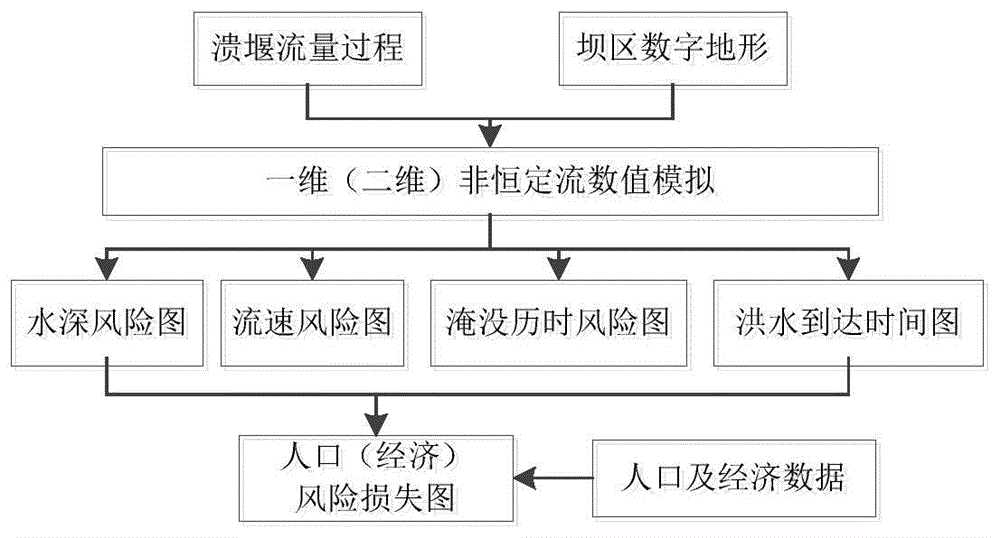
[0040] please see figure 1 , the risk map in this embodiment includes a water depth risk map, a flow velocity risk map, a submersion duration risk map, a flood arrival time map, a population risk loss map and an economic risk loss map.

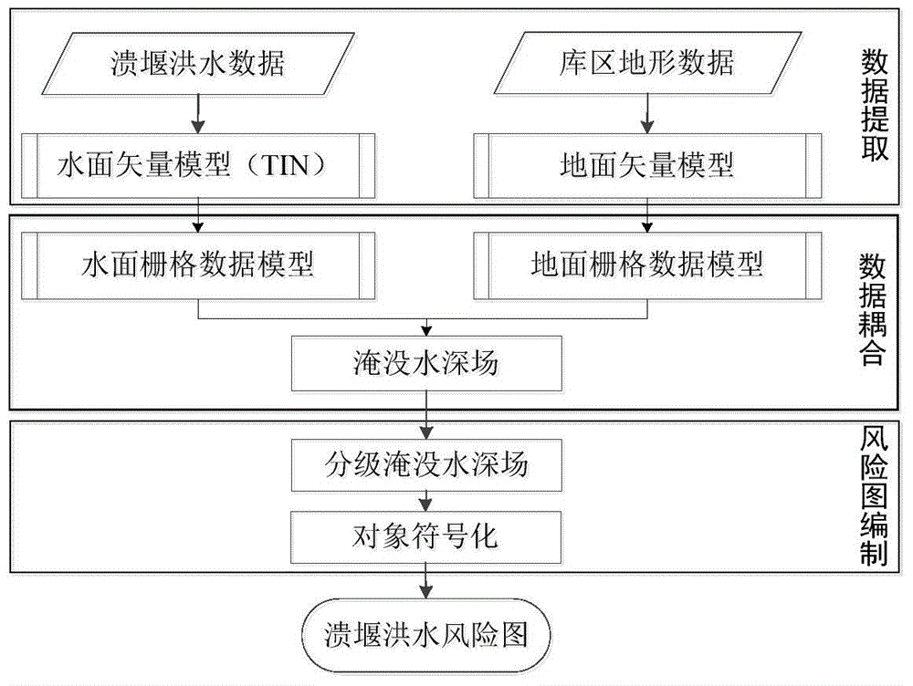
[0041] please see figure 2 , a method for compiling an earth-rock cofferdam breach flood risk map provided in this embodiment includes the following steps:

[0042] Step 1: Data extraction, the data includes weir breach flood data and reservoir topographic data, which is the basis for compiling the risk map; among them, th...


PUM


Abstract

The invention discloses an earth rock cofferdam breach flood risk mapping method. The method includes the following steps: firstly, extracting data including breach flood data and reservoir terrain data which are bases of risk mapping; secondly, coupling the data, to be more specific, performing matching analysis on the extracted data; thirdly, performing risk mapping, to be more specific, performing visual representation on a data matching analysis result. By the method, breach flood evolution data can be extracted flexibly, a raster data model is utilized to replace a vector data model for space analysis, and applicability of complex terrain and universality of spatial analysis position registration method are realized; surface interpolation processing is performed on an inundated waterdepth raster model, limitations of raster data model resolution are overcome, and waterdepth distribution of a reservoir flooded region is considered comprehensively; meanwhile, an isobaths is delimited to serve as a basis for determining inundated waterdepth rates, and waterdepth rating region symbolization is more accurate and objective.

Description

technical field [0001] The invention belongs to the scientific and technical field of water conservancy and hydropower engineering and flood control and disaster reduction, and relates to a method for compiling a flood risk map of an earth-rock cofferdam collapse. Background technique [0002] It is common to build earth-rock cofferdams in water conservancy and hydropower projects. Risk assessment, determination of risk loss and safe operation of cofferdams are important components in the design and construction of water conservancy and hydropower projects. The method of compiling flood risk maps for earth-rock cofferdam failures provides technical support for project safety management. [0003] There are many influencing factors in the diversion system, such as the hydrological uncertainty of the construction flow, the hydraulic uncertainty affecting the construction diversion capacity, the uncertainty of the dam construction schedule, and the uncertainty of the dam structu...

Claims


Application Information

Patent Timeline
Patent Type & Authority Applications(China)
IPC IPC(8): G06T17/00G06F17/50
CPCY02A10/40
Inventor 胡志根程毅刘全吴文洪杨江光杨虎任金明吕国轩邱亚锋
Owner WUHAN UNIV
Learn More