Three-dimensional map rendering and display method and system

A technology of three-dimensional map and display method, which is applied in the direction of image data processing, 3D image processing, instruments, etc., can solve the problems of inability to display large-scale point cloud data, large amount of point cloud data, and low model resolution, and achieve reduction The effect of processing data volume, improving rendering efficiency, and reducing network traffic

Active Publication Date: 2015-08-26
TENCENT CLOUD COMPUTING BEIJING CO LTD
View PDF6 Cites 38 Cited by
  • Summary
  • Abstract
  • Description
  • Claims
  • Application Information

AI Technical Summary

Problems solved by technology

However, in the prior art, the problem with the aerial 3D model is that the resolution of the model is relatively low, and it can only reproduce the distant view of the city, and it is impossible to perform 3D roaming on the street view.
However, the use of semi-automatic reconstruction technology through the street point cloud device requires a lot of manpower, the degree of automation is too low, and there are a large number of parts tha

Method used


Image

  • Three-dimensional map rendering and display method and system
  • Three-dimensional map rendering and display method and system
  • Three-dimensional map rendering and display method and system

Examples


Example Embodiment

[0071] The technical solutions in the embodiments of the present invention will be clearly and completely described below in conjunction with the accompanying drawings in the embodiments of the present invention. Obviously, the described embodiments are only a part of the embodiments of the present invention, rather than all the embodiments. Based on the embodiments of the present invention, all other embodiments obtained by those of ordinary skill in the art without creative work shall fall within the protection scope of the present invention.

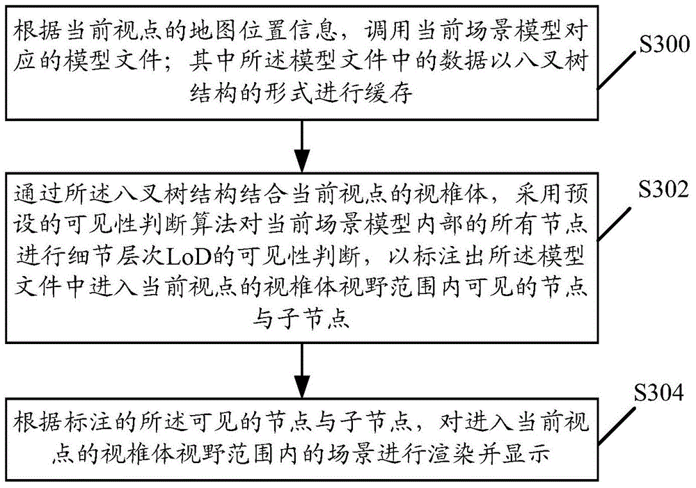
[0072] Combine below image 3 Go to FIG. 7 to describe in detail the specific implementation of the 3D map rendering and display method of the present invention, and explain how to perform the 3D map rendering and display:

[0073] image 3 It shows a schematic flow chart of a method for rendering and displaying a three-dimensional map provided by an embodiment of the present invention, including:

[0074] Step S300: According to the map loc...


PUM


Abstract

The embodiment of the invention discloses a three-dimensional map rendering and display method. The method includes the following steps that: a model file corresponding to a current scene model is called according to map position information of a current view point; data in the model file are cached in the form of an octree structure; based on the combination of the octree structure and the frustum of the current view point, visibility judgment of level of detail (LoD) is performed on all nodes inside the current scene model through adopting a preset visibility judging algorithm, so that visible nodes and child nodes of the model file which enter the view field range of the frustum of the current view point can be marked; and a scene which enters the view field range of the frustum of the current view point can be rendered and displayed according to the marked visible nodes and child nodes. The invention also discloses a three-dimensional map rendering and display system. With the three-dimensional map rendering and display method and system of the invention adopted, rendering efficiency can be improved, and network traffic can be reduced, and large-scale point cloud data can be displayed for users through Web three-dimensional technologies.

Description

Technical field [0001] The invention relates to the field of computer network communication, in particular to a three-dimensional map rendering and displaying method and a three-dimensional map rendering and displaying system. Background technique [0002] The existing 3D map technology mainly uses a triangular mesh model for display. From the data source, it can be divided into two methods: aerial 3D reconstruction and point cloud semi-interactive 3D reconstruction. Both Nokia's Here map and Google Earth use the 3D model obtained by the aerial image 3D reconstruction technology, and then use the level of detail (LoD, Level of Detial) technology to display the city's buildings and other information to users, such as figure 1 Shown is a schematic diagram showing a three-dimensional map in the prior art. [0003] The point cloud data collected by the street view light detection and measurement (Lidar, Light Detection And Ranging) equipment is also applied to the three-dimensional ma...

Claims


Application Information

Patent Timeline
IPC IPC(8): G06T15/00
Inventor 冯路马腾
Owner TENCENT CLOUD COMPUTING BEIJING CO LTD
Why Eureka
Try Eureka