
Ridge-regression-extreme-learning-machine-based local path planning method for outdoor robot

A technology of local path planning and ELM, applied in the field of robot navigation, which can solve the problems of increased computational complexity and difficult application of intersection planning.

Active Publication Date: 2015-09-16
CENT SOUTH UNIV
View PDF5 Cites 27 Cited by
  • Summary
  • Abstract
  • Description
  • Claims
  • Application Information

AI Technical Summary

Problems solved by technology

[0003] At present, scholars at home and abroad have carried out a lot of research work on robot path planning methods, mainly including path planning methods based on heuristic search, intelligent bionics, behavior planning, and reward learning, and have achieved good results in global path planning. It is difficult to plan for the intersection planning in the open and without ground signs, and the computational complexity increases sharply with the transient environment
However, the local path planning method in the outdoor environment needs to have strong generalization, and is suitable for non-specific scenarios with abnormal road conditions; at the same time, under outdoor navigation conditions, sudden obstacles are unpredictable, how to improve outdoor robot collision avoidance Or the real-time performance of obstacle avoidance, while ensuring that the optimal road conditions are approached, is a practical issue worthy of further study

Method used


Image

  • Ridge-regression-extreme-learning-machine-based local path planning method for outdoor robot
  • Ridge-regression-extreme-learning-machine-based local path planning method for outdoor robot
  • Ridge-regression-extreme-learning-machine-based local path planning method for outdoor robot

Examples


Embodiment 1

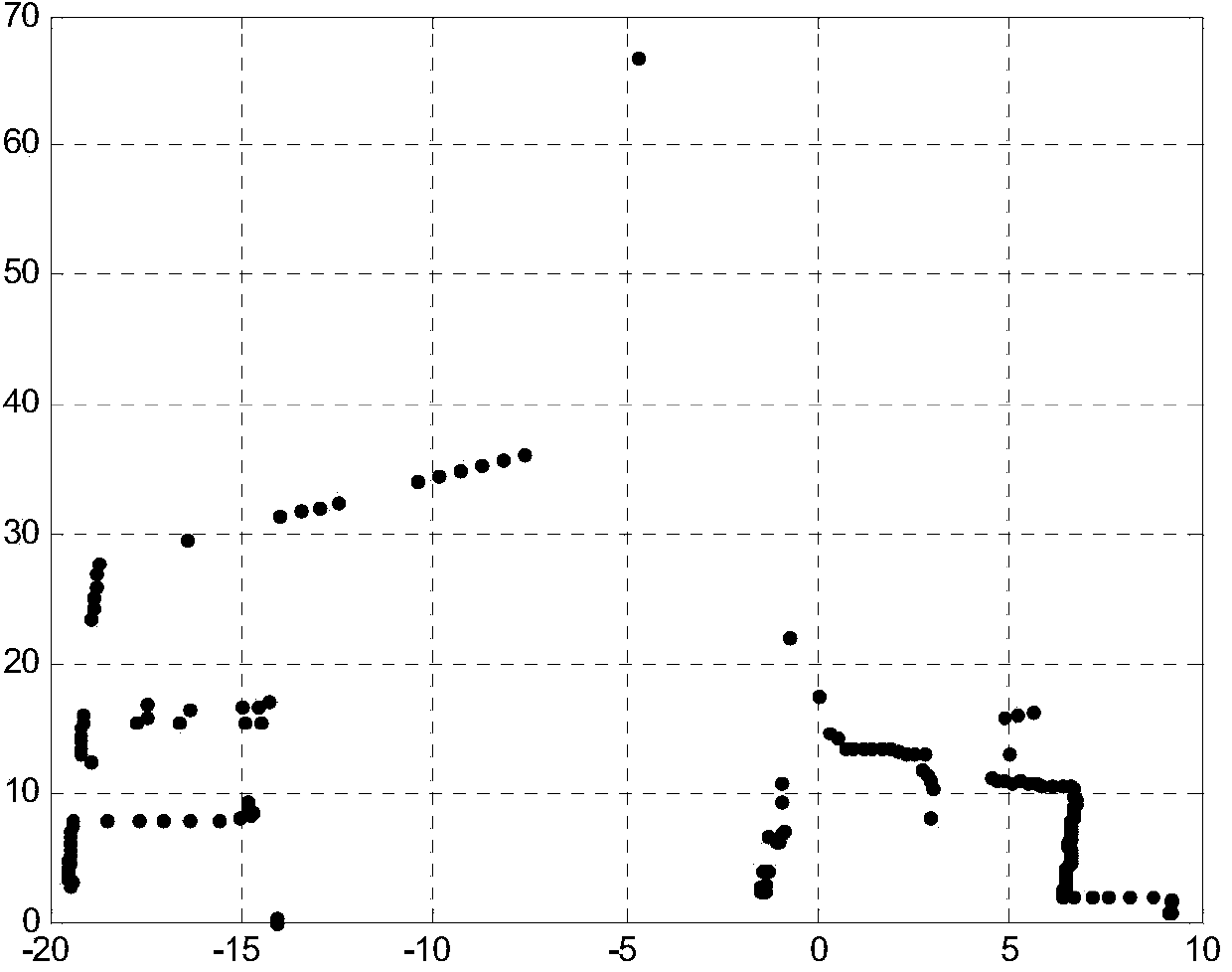
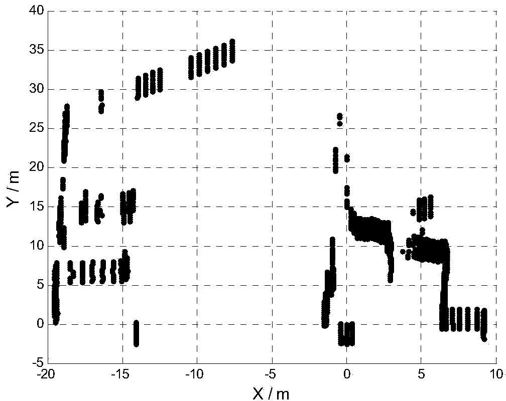
[0142] In this embodiment, the experiment is completed by selecting the scene in the railway campus of Central South University. The campus environment is an unstructured road with a width of about 10m. Buildings with steps, buildings with squares, etc., and various vegetation, such as taller trees, shorter ornamental plant lights; there are other driving or stopped vehicles, single pedestrians or multiple passing vehicles on the road ahead of the outdoor robot. Pedestrians and so on.

[0143] The outdoor robot described in this embodiment is equipped with sensors such as laser radar, millimeter-wave radar, GPS, inertial autopilot, camera, etc., and uses a computer with Intel E7500 dual-core processor, 2.93GHz main frequency, and 2GB internal memory; the software platform of the experiment is : Use the Windows 7 Ultimate operating system, the compilation environment is Matlab R2010b, and the C / C++ programming language is used. In the actual environmental information collectio...

specific Embodiment approach

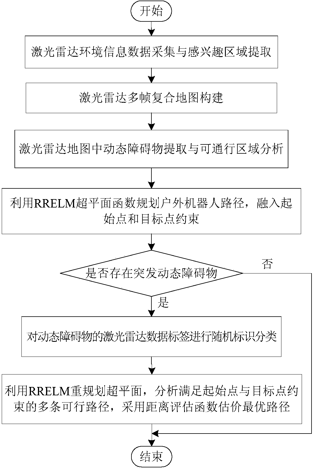
[0169] 4. Use the RRELM hyperplane function to segment the lidar environment information feature points, and consider the starting point and target point constraints of path planning, so as to obtain the local path planned by the robot. The specific implementation method is:

[0170] (a) Incorporate the starting point and target point constraints and add it to the hyperplane function. It is necessary to form several auxiliary data points around the starting point and the target point, and list the auxiliary points on the left as class 1, and the auxiliary points on the right as class 1 class 2, and then all are added to the original data, and the learning model is obtained by training with RRELM.

[0171] In this embodiment, according to the starting point (-5, 0) and target point (0, 40) in the passable area, 6 auxiliary points are generated on the left and right sides of the two points: starting point s=(- 5, 0) around s1 = (-4.5, 0), s2 = (-4.5, 0.5), s3 = (-4.5, -0.5), s4...


PUM


Abstract

The invention discloses a ridge-regression-extreme-learning-machine-based local path planning method for an outdoor robot. The method comprises the following steps: step one, collecting environment information and extracting a region of interest by using a laser radar; step two, constructing a composite map of multi-frame laser radar data by using a robot track calculation method; step three, carrying out data point clustering and logic identification of the laser radar, extracting a dynamic obstacle and road boundary, and identifying a passable area in a laser radar map; and step four, planning a hyperplane by using ridge regression extreme learning machine (RRELM) and integrating initial point and target point constraints of path planning, thereby obtaining a local planning path of a robot. With the method, the generalization performance of path planning learning by the machine is improved in an outdoor non-specific scene, so that the local path of the outdoor robot becomes smooth and thus convenient tracking can be realized.

Description

technical field [0001] The invention belongs to the technical field of robot navigation, and in particular relates to a local path planning method for an outdoor robot based on a ridge regression ultra-limit learning machine. Background technique [0002] Outdoor robots are unmanned ground wheeled robots that can autonomously sense and actively cruise, and complete predetermined tasks. Autonomous vehicles are a typical application. Path planning in the outdoor environment is one of the key technologies in the field of robot navigation. The outdoor environment refers to the natural environment without a specific scene, and the map information is not completely known. Compared with the structured environment, the road conditions in this environment are complex and unpredictable. For this reason, in the process of robot navigation in outdoor environment, it is easy to encounter unpredictable abnormal road conditions such as ramps, curves or sudden obstacles. It is necessary t...

Claims


Application Information

Patent Timeline
IPC IPC(8): G05D1/02
Inventor 余伶俐龙子威周开军
Owner CENT SOUTH UNIV
Learn More